All Activity
- Past hour
-

Central PA Winter 25/26 Discussion and Obs
mahantango#1 replied to MAG5035's topic in Upstate New York/Pennsylvania
And just like that sun came back out temp above freezing, snow disappeared. -
Leaning heavily towards a Banner Elk weekend (Wed-Sun). Just seems like Miller As don’t exist anymore. More importantly, cold air never meets up with moisture east of the peaks. Jan 2022 remains the last meaningful event.
-

Central PA Winter 25/26 Discussion and Obs
canderson replied to MAG5035's topic in Upstate New York/Pennsylvania
Holy wind -

January 2026 regional war/obs/disco thread
dendrite replied to Baroclinic Zone's topic in New England
Not that we care about a d7 op sfc map, but that’s why I joked only 28 runs to go. -
Speaking of which do you have any resources on storms like this? I got stuff like the December events (jet steak WAA FGEN) figured out mentally when tracking but not really anything like this where it seems all vorticity driven and how that ends up producing snowfall. Would love it if you could explain those differences or recommend some reading
-
You’re so misguided about the AI Euro. To me in the medium range it’s the default strongest weight.
-
Snow showers with cold front late afternoon. My NWS forecast is for snow showers and falling temps this afternoon. Snow showers in the evening. Snow could be heavy at times. I guess they're expecting a couple of snow squalls.
-
Central PA Winter 25/26 Discussion and Obs
Blizzard of 93 replied to MAG5035's topic in Upstate New York/Pennsylvania
It Just arrived in Marysville as well. -

January 2026 regional war/obs/disco thread
dendrite replied to Baroclinic Zone's topic in New England
-
Cold is crushing and may kill it. Lol
-

January 2026 Medium/Long Range Discussion
Scarlet Pimpernel replied to snowfan's topic in Mid Atlantic
Anything about the @CAPE storm, on the Euro? -
The model should use the 4dVAR initialization scheme used by the leading models (ECMWF, GGEM, UKMET). It's difficult to justify not using the best-in-field initialization at this point in time. The inferior initialization puts the model at a disadvantage right from the start. Once the GGEM moved to the 4dVAR initialization, along with other changes that were made, it rocketed to the #2 model in terms of key verification metrics.
-
Mood flakes here
-

Central PA Winter 25/26 Discussion and Obs
mahantango#1 replied to MAG5035's topic in Upstate New York/Pennsylvania
Nice snow squall here. Temp dropped below freezing grass turned white with 48mph wind gusts. -
Yes. Fun things happen with you have an upper level low closing off to your south.
-
This is totally a thoughts and prayers event. 80% going to be broken hearted. Don’t think I’ll be relaxed until I’m shoveling. If we could be objective though, it’s potentially a really cool event to watch just from a dynamics perspective.
-
Idk, but at 246hrs it looks to me that the Euro is setting up for an overrunning event.
-
The risk of that cold air mass sits right outside of d10. The 12z GEM got to where the Euro did at 240...we just couldn't see the rest of the run. That would be something else. Still, I think we have some light snow chances prior to that...but if the GEM and Euro are correct, that would quiet the pattern after 240.
-

E PA/NJ/DE Winter 2025-26 Obs/Discussion
Birds~69 replied to LVblizzard's topic in Philadelphia Region
I always like a little something something but my priorities today are etched in stone. 1.Birds 2.Birds 3.Peak at models Worst case scenario? Birds get trounced and blow torch models with no good news in sight.... -
If the ULL closes off someone will get a moderate/decent event, really hard to pinpoint that, but models still not all on the same page with that even happening. Give it another 1-2 cycles. .
-
Would advocate for storm mode inside of HR 48 and a heavily moderated thread.
-
Just saw a few stray flakes wander by after getting lost on their journey to our friends to the west. Not sure if I’m supposed to call that a trace or not…
-
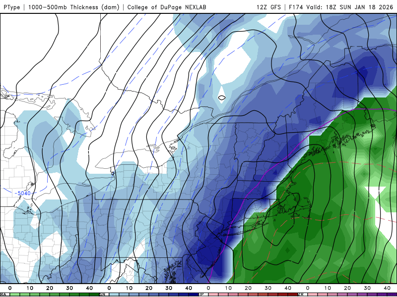
Looks like Euro and GFS give everyone a 2"-4" event with localized 5" spots.
-
Barring some big changes in the guidance, it continues to appear that the Thursday-Friday period will see some precipitation, but probably < 0.50". A series of waves should move along a slow-moving front, but the consolidated low will likely develop too far offshore for a more significant impact. Larger impacts remain more likely across southeastern and eastern New England. Currently, fewer than 20% of EPS ensemble members show 0.50" or more QPF for the New York City area. The 1/11 0z EPS ensemble mean QPF was pretty close to the 16z NBM output. Overall, there remains little evidence that a pattern conducive to large snowstorms coupled with the ingredients necessary will be in place by the January 15-16 timeframe. Nevertheless, rain showers could transition to snow showers or even some periods snow around the New York City area and its immediate suburbs. A light accumulation of snow is plausible. More immediately, a line of rain and/or snow showers accompanying a frontal passage appears likely to cross the region late this afternoon or early this evening coupled with gusty winds. No accumulation is likely in and around NYC, but temperatures should fall from the middle 40s into the upper 30s or lower 40s during the frontal passage.
-
Shure looks like it should be with that look. Question is, does something cave here for better.. or worse


