All Activity
- Past hour
-
1.15” imby from approx 10pm Tues to 6am Wed. 2.93” in July so far.
-
 Will be home brew
 -
We finally got under one of those nearly stationary cells. I think 0.8-1” or so between 10pm and this morning.
-

Hoisting the Sultan Signal: Heavy Rain Event July 5-7
kdxken replied to WxWatcher007's topic in New England
The 2.75 inches yesterday appears to be the largest rainfall since December 2023. Even that was over a 2 day period. Used AI so it might not be 100% correct. Soaker for sure. -
 top farmacia online: acquisto farmaci a domicilio Italia - farmacia online Italia
 -

Central PA Summer 2026 Discussion/Obs Thread
pawatch replied to Voyager's topic in Upstate New York/Pennsylvania
68 degrees for the low. The river up here took a 4 foot jump. Not exactly sure where the rain came from. We have had less than a 1/2” -

Hoisting the Sultan Signal: Heavy Rain Event July 5-7
CoastalWx replied to WxWatcher007's topic in New England
Well I was correct there. Look at srn CT to FMH. That’s where the fun was. - Today
-
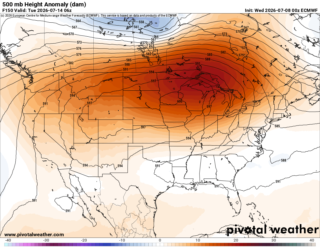
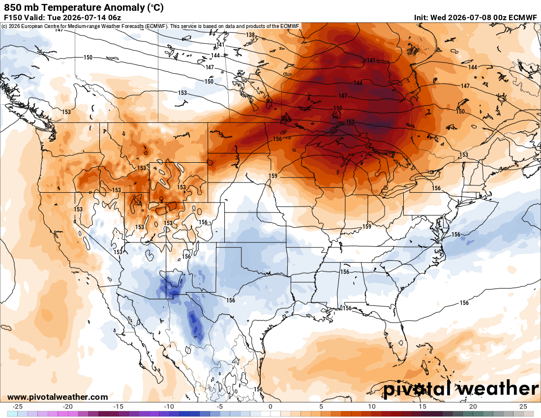
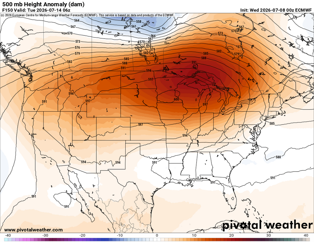
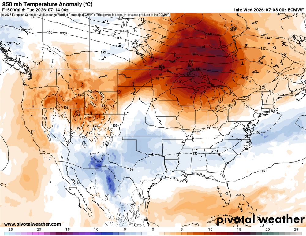
 I wanted to follow up on a post I did last night. Some details here that may not be so apparent to all, and this evolving pattern provides a good example how it's not "one-size-fits-all" for a given pattern and sensible wx. The details count and help quantify a fcst better. In this case, it will not be the same as the pattern we had last week w/ the snow in the Northern Rockies and big heat in the East, despite a strong 500 ridge fcst. I attached a GIF loop of the GFS 500H/V for the next 10 days. You can see the ridge axis/center that forms so far N, you actually get tropical-type easterlies across the srn half of the CONUS and westward moving disturbances. Not tropical waves per se, just weak 500 lows. The first shows up over KS/MO/OK at 96 hr and then moves W under the ridge to the Central Rockies where it merges w/ a vort center that is stuck within the ridge, and then it all ends up moving N and then E around the top of the ridge. And then look at about 156 hr on the SC/GA coast, a small 500 low develops moves W and eventually ends up over srn NM. In this case, despite the 600 dm ridge, this is not classic big heat pattern for the CONUS. It's tropical and unstable w/ easterlies across the srn 1/2 of the CONUS and in the Rockies, despite ridging aloft, weak disturbances are embedded w/ a lot of mid-level RH present. So this means considerable amounts of diurnal RW/TRW, which keeps temps from getting really hot, and is why the 850 temps avg slightly below normal across the srn 1/2 of the CONUS (150 hr ECM 850 anomalies attached) Also, and I failed to mention this yesterday, yes, it is large and strong ridge, but also a *broad* W to E ridge and wavelengths are not sharp, unlike what happened last week. Not all ridges of high pressure are alike, but some act like that. Seriously, one well-known TV met actually has said, "two heat domes will merge and become one large one next week." As if that means anything as to more extreme temps? That's not how it works for high pressure. This person is trying to force the notion that when two low pressure merge (like a ET low and TC), it works the same for high pressure, and thus an end product more intense. Vapid and linear thinking, preying on public ignorance. Ppl just making things up now for hype! The "two heat domes" that will "merge" mentioned above. If you look at the 500 over the CONUS now, they are typical subtropical 500 highs you would find in mid-summer, one over the Desert SW and another one near the Bahamas. So every ridge of high pressure that has climo hot wx is a heat dome now pushed as unusual? And these two subtropical highs, look at the 500 evolution, there is no sign of any "merging" here. I know I have said stuff along these lines before, but I wanted to share another example of how statements on wx just keep devolving more into slop, and at the same time, point out for the ppl on the forum here some of the finer points of a ridge pattern in this case that from a bird's eye view, it many looks the same, but upon closer look, there are important differences that make for different sensible wx.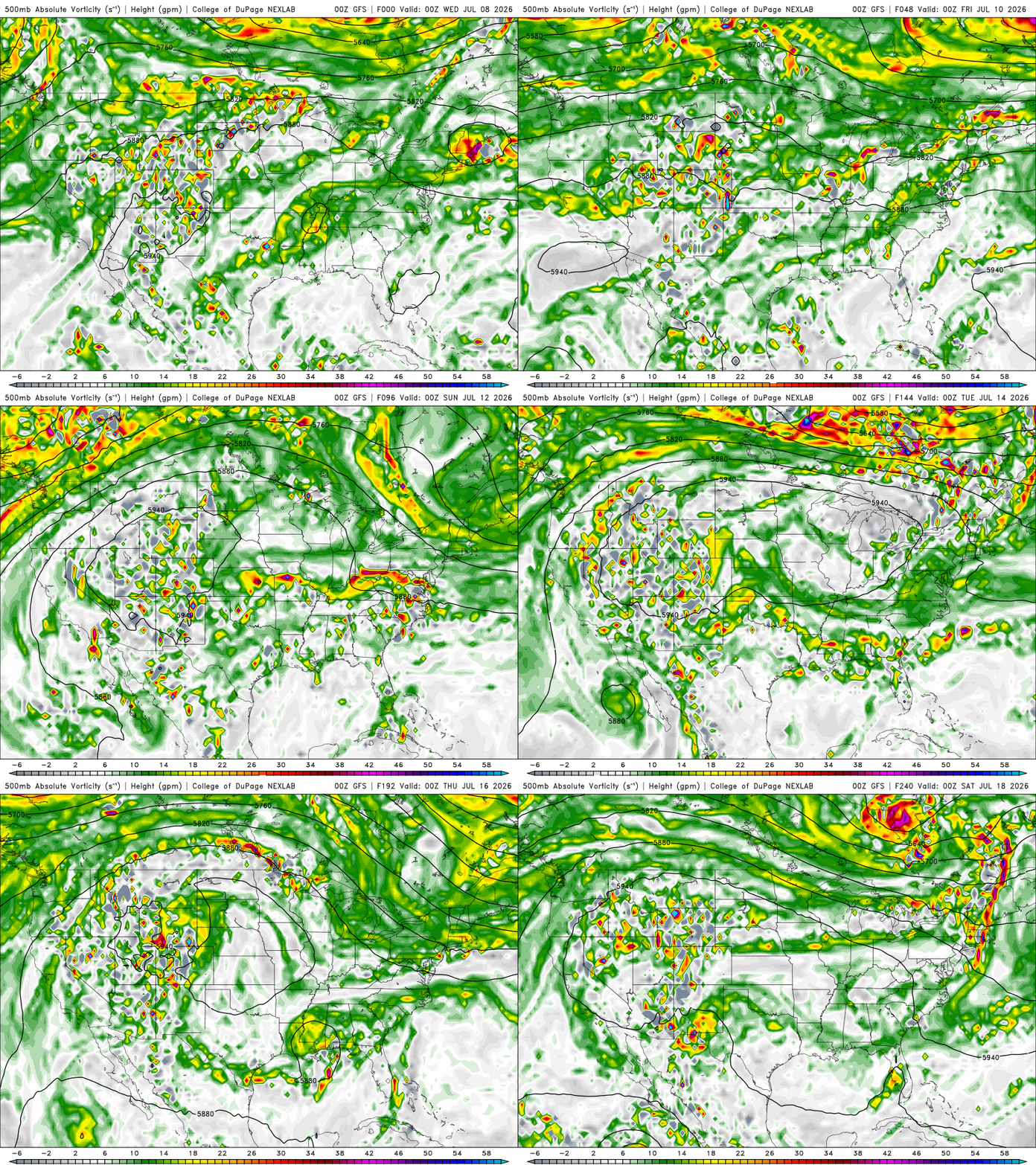
-

2026-2027 Super El Nino
BlizzardWx replied to Stormchaserchuck1's topic in Weather Forecasting and Discussion
I think stuff like this is where past analogs could fall short. This basically has never happened, so while I wouldn't say past analogs have no utility we have to be careful to not oversubscribe what we know. We may well see equatorial convection further east than has ever been seen, and so forcing will be uniquely far to the east as well. My comment isn't being directed at you btw, just in general, a caution for all. -
Received 0.24 down here today - first since Saturday- for a " event " total of 0.68.... Awesome, love Montana/Wyoming - drove through the two states once in late April 2021 on a around the country road trip ... Got to see one place that always fascinated me as a kid growing up as a American history buff trying to picture the scene in my mind - Little Bighorn , Custer's last stand battlefield... Drove south on 191 out of Bozeman through West Yellowstone along the Gallatin River toward Idaho- Most amazing views - incredible almost unreal scenic road...
-
EMLs are tricky. They are most prevalent and strongest when the atmosphere is very warm ("warm" being relative to the time of year). This mean things are often capped. So despite tons of CAPE and shear, no storms will develop. But if you storms to fire, then you have a primed environment for svr storms. Weak EMLs are often present, w/ mid-level lapse rates 6.5-7.0 C/km, in many tstm days here. However, you want to see at least 7.0 C/km solid for noticeable results or differences. And just a 0.5 C/km difference is huge b/c the range is small. The dry adiabatic lapse rate is 9.8 C/km and the moist adiabatic lapse rate varies depending on temp and moisture, but in the warm season, anything under 6.0 C/km is not good (it does not mean you can't get big storms though). Generally, look for greater than 7.0 C/km at mid-levels in a fairy thick layer on an observed or fcst model sounding. On the models for mid-level lapse rates, they use 700-500 mb. However, that can be misleading. You may have at 150 mb thick EML between those two levels, or say from 750-550 mb, and this qualifies. EMLs do a couple of things that lead to better storms. 1) EMLs promote elevated CAPE, and this CAPE exists independent of diurnal effects, so loss of daytime heating is not as much a factor. And during the day before the convective temp is reached, you already have CAPE aloft just waiting to be tapped, and links w/ building sfc-based CAPE. In the end, you get considerably stronger updrafts in CBs. 2) Where an EML exists is often the best hail growth zone in a CB, so hail at the sfc and/or larger hail is more likely (steep lapse rates and higher mid-level CAPE mean more vigorous updrafts at mid-levels). 3) And along the same lines as above, the EML can be in or close to the mixed phase layer of the CB where charge separation occurs the most, so that means more LTG, esp. in-cloud LTG. Solid EMLs on the East Coast are not common, at least those that occur in sync w/ proper low-level moisture and dynamics/forcing to result in significant svr wx events. Two of the biggest ideal EML events are June 23, 1944 Mid-Atlantic tornado outbreak and the June 8-9, 1953 Great Lakes-New England tornado outbreaks. Another one was July 10, 1989, which is the record for most tornadoes in a single day in New England. That day I experienced first-hand, and that’s when I took note of the EML factor. IAD sounding 00z on the 11th had a distinct EML present. However S of NYC, not storms occurred b/c it was capped. So for the Mid-Atlantic and Northeast's biggest tornado events, typically a solid EML is present, but everything else has to line up almost perfectly for an actual high-end event. In general, having an EML present is a good thing if you want more intense tstms and more overnight storms. I really like what I see coming up for the CONUS 500 pattern. Big hot ridge to our W and we are in persistent WNW or NW flow aloft. This is how you advect a solid EML from the Plains to the East Coast, and WNW or NW flow historically had led some of the biggest svr wx outbreaks in the summer months for the Mid-Atlantic and Northeast.
-
Only one thing to do: fire Elias and clean out the FO. But I'm not sure we need a full rebuild, or that all our young players are simply busts. Not buying that part...I think it's Elias & Sig's system that has been choking the core. Key example? Look how well Adley is doing this year. What did he say? "Simple thoughts at the plate". Which makes ya wonder...where did the complications come from? We were all ready to call him a bust! But his bat is all the way back, and now he can throw people out thanks to a change in coaching!
-
Not a drop today at home. Gorgeous mid 60s day here in Montana though
-
I'll bet the under on that. Alonso is not gonna wanna just up and switch when he just got here just because things are rough this first year. Players do not always think the way fans do. (Why you are so hung up on this idea of him in particular I have no clue--it is incredibly rare for that kind of deal to be given up on by player or team in just half a season...c'mon you ever heard of that? Lol It would have to be an unusual, toxic situation for that to happen that fast. And besides, Alonso seems like the type to go all in when he commits to a team and a city. So between that and ownership, this being the biggest investment made so far, definitely stepping in and saying "heck no this is dumb" if anybody in the org even floated that idea...he is not going anywhere dude, lol And I think the assumption everything will be torn down under a new GM is premature. There is more to work with here than some think. And what if...it's the system of over emphasis and micromanaging of analytics (and culture of the FO) is the culprit, and not the talent? You change that and this can turn around in a year, imo New GM could manage existing talent better, and then build around them better.
-
 I like the deck chair that slides back and forth like something out of Poltergeist.
 -
Hoisting the Sultan Signal: Heavy Rain Event July 5-7
vortex95 replied to WxWatcher007's topic in New England
Sounds like damage control in link title --"not nearly the rainfall we need." Ok, who ever said it would be enough? The point is we got a solid widespread rain event. You have to start somewhere to come out of drought conditions. Geez, wx does not work in nice, neat, even increments and balances out 1-1 when talking short periods of time. A case of you can look at the glass half-full or empty (yes, the pun is there but not intentional!). -
Hoisting the Sultan Signal: Heavy Rain Event July 5-7
vortex95 replied to WxWatcher007's topic in New England
Sorry, I couldn't resist! -
Hoisting the Sultan Signal: Heavy Rain Event July 5-7
vortex95 replied to WxWatcher007's topic in New England
What happened to your warm front *absolutely* needed for the big R+ in a summer month? Nor'easter is still a nor'easter in July. Only difference is that they are weaker and smaller, but much higher PWATs tend to compensate to give solid QPF. The OER was neat to see today streaming in from the due E! -

2026 Mid-Atlantic Severe Storm General Discussion
SnowenOutThere replied to Kmlwx's topic in Mid Atlantic
A question I’ve wondered about for a while is if our area always benefits from emls. The tor threat way back in March had a weak one and it kneecapped our cape. It seems that sometimes that temperature increase (or slower rate of decrease) does more harm than it helps.- 979 replies
-
- 1
-

-
- severe
- thunderstorms
- (and 7 more)
-
 The AMOC stuff is interesting to me. I've seen some theories regarding the cold blob possibly causing persistent troughs over that area Tip's reference to our corner of the planet being cooler relative to other regions?
 -
Hoisting the Sultan Signal: Heavy Rain Event July 5-7
vortex95 replied to WxWatcher007's topic in New England
Even if it was 4-8" widespread, it still would not have been that bad overall b/c it was going to be spread out and most importantly, very dry antecedent conditions overall across SNE! So much of the MSM and hype masters have no clue, or do know, but ignore b/c deflates hype. They think "one-size-fits-all" and the one size is always means the worst. That's now how the wx works and we can do much better now due to improved modeling and understanding of the wx. There is no effort to quantify or scale wx events anyone -- again, it's always "the worst." So you see my overall critical position on how wx is treated in general is not w/o merit. This rain was very beneficial and we needed it, but that is good news and doesn't sell. -
Hoisting the Sultan Signal: Heavy Rain Event July 5-7
vortex95 replied to WxWatcher007's topic in New England
Yes, you could clearly see two level of pcpn on radar, low and high, moving in different directions and overlapping, which likely lead to the dense small drops (super "sheet" drizzle?). Almost like warm process rain but w/ more baroclinicity. -
Hoisting the Sultan Signal: Heavy Rain Event July 5-7
vortex95 replied to WxWatcher007's topic in New England
Nice li'l tight/coherent wrap up. Models showed this well. Don't always need a deep sfc coastal low for "fun 'n games!" -

Hoisting the Sultan Signal: Heavy Rain Event July 5-7
Snowedin replied to WxWatcher007's topic in New England
Couple days of shrinkage then back to our usual low hanging family jewels. We shall overcome these trying times. -
Hoisting the Sultan Signal: Heavy Rain Event July 5-7
vortex95 replied to WxWatcher007's topic in New England
Can you imagine the consternation alone if this was a fcst snowstorm? 24 hr ago, DXR would have had 2 ft and PVD a foot, and a dusting at BOS. CoastalWx would be like, "HOW CAN THIS BE????!!!!" and basically ready to call it quits, and then the big backlash comes in and saves the day! Reminds a bit of the Bliz of 96 in ern MA. Got about 5" in Woburn w/ an initial burst in the evening, then MEH for the next 8 hr (2SM -SN and I got about 2"). Then the "backlash" came in and I got another 8". So a great storm total (for 1996), but it was piecemeal. Not a smooth event! Also, one of the storms in the Jan-Feb 2015 blitz. SNE got a burst of S+ in the evening, and then it completely stopped, and BKN conditions w/ stars visible along the S Coast. This mesoscale thing w/ a arc of snow moved into srn NH, then drifted back S after midnight, and then incredible development w/ super TS++ predawn into later that morning. Rumor has it CoastalWx passed out a few times due to his ecstasy! Again, not a smooth event, but it all worked out in the end!