All Activity
- Past hour
-

E PA/NJ/DE Winter 2025-26 Obs/Discussion
Birds~69 replied to LVblizzard's topic in Philadelphia Region
Ryan Hall, Y'all and the GFS...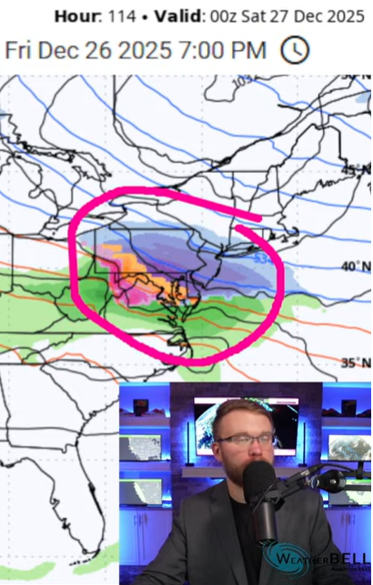
-

White Christmas Miracle? December 23-24th
moneypitmike replied to Baroclinic Zone's topic in New England
Updated GYX map. Fingers crossed. -
.thumb.png.4150b06c63a21f61052e47a612bf1818.png)
December 2025 regional war/obs/disco thread
HIPPYVALLEY replied to Torch Tiger's topic in New England
I really want snow, but I also really like Ray’s masochistic posts, so it’s hard to know which way to root. -
 Updated NWS Map:
-

December 2025 regional war/obs/disco thread
nutmegfriar replied to Torch Tiger's topic in New England
He's a nibbler, which is exactly what I don't want as a closer. I'm happy he's out of the Bronx. -

Occasional Thoughts on Climate Change
WolfStock1 replied to donsutherland1's topic in Climate Change
Worldwide food production has increased *four-fold* since 1960. https://ourworldindata.org/agricultural-production If MMGW was a significant problem for food production I'm pretty sure that wouldn't be the case. I wouldn't propose that there will be zero impact on food production - however it is clear to anyone who knows how things work that any such impact will be vastly smaller in scale that mankind's ability to adapt and will more than offset any such negative impact (if there was to be one), such as happened after the big "Population Bomb" food-shortage scaremongering of the late 60's. Such scaremongering has been proven wrong time and again, and as such deserves to to be mocked. (World population grew by 2.7x during this period; thus food production increase outpaced - and continues to outpace - population growth, especially as population growth continues slowing.)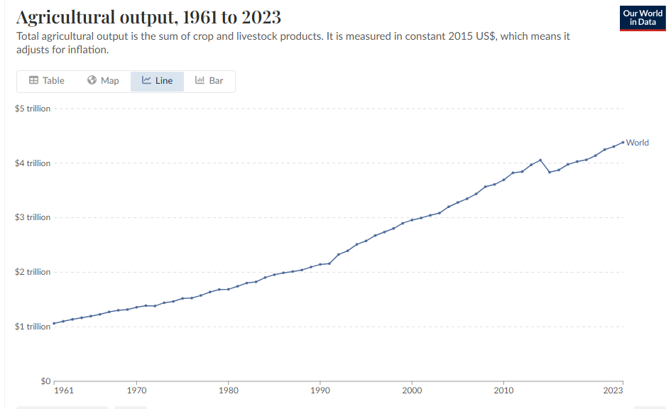
-
December 2025 regional war/obs/disco thread
moneypitmike replied to Torch Tiger's topic in New England
fixed. No one else even close. -

-
Yep next week will be cold. We need that trough axis about 500 miles to the west.
-
Central Park may hit 4+" for December with 12/23 and 12/26. That's a great signal for the rest of the winter over there.
-
I did a total thru 150hrs so some may be from tonight
-
-
So much for the big warmup. Great to see!
-
Yes, The first ones of the season too is the other period that they will do this especially if it affects the commuting hours.
-

December 2025 regional war/obs/disco thread
Chrisrotary12 replied to Torch Tiger's topic in New England
Cue Coastal complaining about the blob off California. -

White Christmas Miracle? December 23-24th
The 4 Seasons replied to Baroclinic Zone's topic in New England
yea thats what i figured. i've seen a few weird ones like this in the past, and i remember one in November one time that was sub-advisory 1-3" but they put one out because it was the first one of the season, and it was right at rush hour. -

White Christmas Miracle? December 23-24th
weatherwiz replied to Baroclinic Zone's topic in New England
I think it also has to do with the timing plus the increased holiday travel...just a way to increase awareness -
 NWS hiking amounts slightly, I was at 1" or less, now @ 1" - 2"...getting there.
 -

December 2025 Short/Medium Range Forecast Thread
Carvers Gap replied to John1122's topic in Tennessee Valley
Digging through ensemble members. It looks like there is potential for another strong cold front on Jan6-7 - per GEFS. This looks like a very active pattern coming up in regards to cold. Let's hope some precip can work its way in. I would think clippers and NW flow would be on the table for even norther portions of Gulf States IF that pattern verifies. -
We had a bunch of these in 93-94, I feel we've had basically none since minus PDII
-
Sunset times are already increasing went from 4:24 here around dec 10th to 4:28 today
-
Be interested to see ind members cause op not even close to brining snow to Maryland so there’s got to be some big hits in the mix.
-
NWS does this because of holiday travel to make folks aware.
-
December 2025 Short/Medium Range Forecast Thread
Carvers Gap replied to John1122's topic in Tennessee Valley
I know this is a bunch of posts and my apologies. The 12z para GDPS goes back-to-back w/ cold fronts beginning w/ the 28-29th. We could certainly be cold and dry. That is with precedent. However, the storm track should be suppressed with this. With the return flow behind these fronts, one would think at some point either the cold air doesn't get out of the way(over running WAA) or the warm air doesn't get out of the way. To me, the para GDPS is a logical path forward, but by no means not the only one.


