All Activity
- Past hour
-
2.2” in 35 min. Enough to break RadarScope. Pond full again.
-
hoping it keeps heading west a bit more, before making the turn north. Should wring out much of the "extratropicalness" by the time it gets back to the east. (my cool new word for the day)
-

July 2025 Obs/Disco ... possible historic month for heat
dendrite replied to Typhoon Tip's topic in New England
Ditto. Kinda surprised after the rain last night. -
its just crazy. What a difference a year makes.
-

July 2025 Obs/Disco ... possible historic month for heat
dryslot replied to Typhoon Tip's topic in New England
5th day we start with fog up here. -
-

July 2025 Discussion-OBS - seasonable summer variability
jm1220 replied to wdrag's topic in New York City Metro
Brief break this weekend hopefully but it’s a Miami-like regime with it being normal now to have 75+ dews and now mixed with 90+ temps. -
July 2025 Discussion-OBS - seasonable summer variability
jm1220 replied to wdrag's topic in New York City Metro
The 2025-26 ENSO thread covers this quite a bit. I agree and it’s been documented by Bluewave especially how this marine heatwave east of Japan ruins our winter storm setups. And looks like record heat there again. Hoping for an active typhoon season with lots of recurves into that area, maybe that’ll help a little but my hope for winter is very low with that warm water still there. It hypercharges the Pacific Jet which is the opposite of what gets it done here. -
Impressive.
-
0.74"
-

July 2025 Obs/Disco ... possible historic month for heat
HoarfrostHubb replied to Typhoon Tip's topic in New England
First clear morning in a while here. Much better -
0.35" from yesterday evening
-

E PA/NJ/DE Summer 2025 Obs/Discussion
LVLion77 replied to Hurricane Agnes's topic in Philadelphia Region
The only area of the LV that got anything substantial was where that band set up along south mountain into the southern areas of the 3 cities. Most of the Valley looks to have received 1/4” or less - I only got 0.22” in lower macungie. Per radar estimates looks like there was 2“ less than a half mile south of me. It always amazes me how localized storms are in the summertime! . -

July 2025 Discussion-OBS - seasonable summer variability
TheClimateChanger replied to wdrag's topic in New York City Metro
Looks like it made it down to 68F at Elkins this morning, 2F below the record high minimum set in 1916, so they will end their record high minima streak at 2 days. -
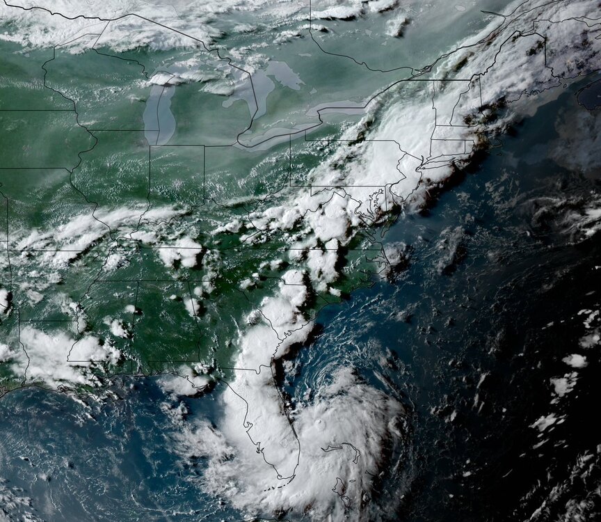
The NCAR AI severe page indicates a hefty chance of severe on Thursday - but SPC has held off on any risk areas due to the uncertainty from MCVs and prior day convection (and the position of the front). Bears watching.
-

July 2025 Discussion-OBS - seasonable summer variability
bluewave replied to wdrag's topic in New York City Metro
It will be interesting to see this time since we usually don’t get widespread 100° heat after these major flash flood events. This has been very monsoon-like during recent summers. First we get the widespread 100° heat followed by a 5”+ or 10”+ deluges. -
July 2025 Discussion-OBS - seasonable summer variability
TheClimateChanger replied to wdrag's topic in New York City Metro
Record high minima tied at Bridgeport (73F) and Islip (74F) yesterday. Not even record-breaking rainfall can flush out this unbelievably resilient heat. Elkins, West Virginia also saw a record high minimum tied (69F), while Concord, New Hampshire, Burlington, Vermont, and Beckley, West Virginia, each matched their 2nd warmest low temperature for July 14. Pittsburgh, PA, Charleston, WV, and Huntington, WV all matched their third warmest low for July 14. There would have been additional records, but unfortunately, several places were unable to retain their heat through 1 am EDT. -
At least 3 reports of 6”+ from Union County where the SPC HREF had its local max. So a good performance from the model. This almost had some PRE-like characteristics with the weak tropical low near Florida. Daily Precipitation Report Station Number: NJ-UN-42 Station Name: Westfield 0.8 WSW Data Explorer Observation Date 7/15/2025 6:24 AM Submitted 7/15/2025 6:26 AM Gauge Catch 6.24 in. Notes Historic rain for 4 straight hours, +1” / hour Daily Precipitation Report Station Number: NJ-UN-39 Station Name: Clark Twp 0.7 SSW Data Explorer Observation Date 7/15/2025 7:00 AM Submitted 7/15/2025 7:13 AM Gauge Catch 6.12 in. Notes I submitted several significant weather reports during the storm. A multitude of water rescues were conducted by the Clark Fire Department. Daily Precipitation Report Station Number: NJ-UN-36 Station Name: Clark Twp 1.3 ENE Data Explorer Observation Date 7/15/2025 6:59 AM Submitted 7/15/2025 7:04 AM Gauge Catch 6.67 in. Notes Mostly Sunny…humid…72F

- Today
-

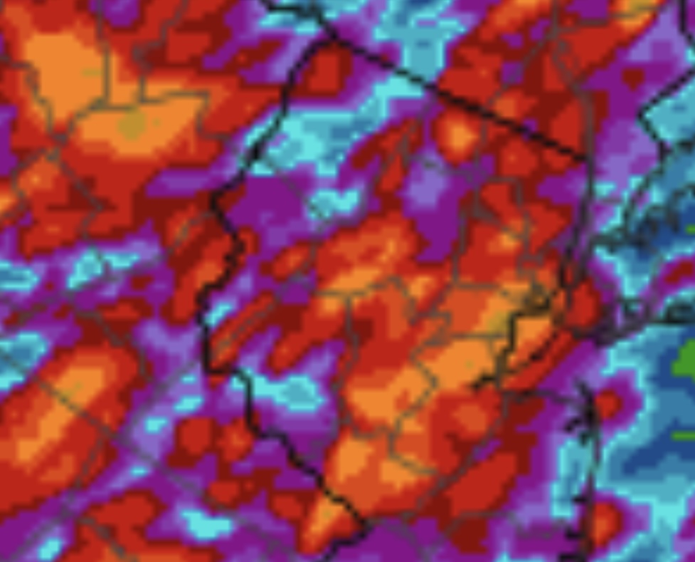
2025 Short Range Severe Weather Discussion
A-L-E-K replied to Chicago Storm's topic in Lakes/Ohio Valley
0z run was hot with that mcv, 6z a miss north, hoping for the best -
 I agree. Hopefully, there will be an update this morning.
 -
Nice drink, 1.2. Happy garden
-
84 for the high yesterday and .75 rain.
-
I ended up with 1.04" yesterday.
-
 Thanks for this Don--- hoping they update this better reality by Noon today. Clearly more than 5" fell. Response is pretty severe in parts of NYC subforum.
 -
0.82 here i9n this part of Wantage NJ. I'll be looking for a listing of NWS posted rainfall amounts from OKX and PHI on this thread later today. Can't do CoCoRaHs post till this afternoon. am looking at probably one more FF/SVR thread this week centered on Sunday into early Monday. Small chc thread for Wed afternoon-Thu but am pretty sure we'll need a thread for Sunday, in part due to antecedent pockets of saturated turf.