All Activity
- Past hour
-
97F day 2 in the books.
-
Could be that new spider that's laying eggs in folk's nasal cavities. Apparently the gestation period is quite short so you should be on the uptick quite soon.
-
Been like that most of the summer. Scorched North.
-
Heat index lower than the temperature lolz. Nice breeze here.
-
Neutral Enso
-
 Temperatures rose into the upper 80s and even lower 90s across the region. Far more impressive heat covered upstate New York, northern New England, southern Quebec, and New Brunswick. Near record to record highs were commonplace. Highs included: Bangor: 96° Buffalo: 91° Burlington: 96° Caribou: 94° (old record: 92°, 2020) Concord: 97° Manchester: 96° Plattsburgh: 91° (tied record set in 1970) Saranac Lake: 90° Miramichi, NB hit 99°. That is its second highest temperature on record. Montreal also topped out at 94°. Tomorrow through Thursday will be hot days across the region. Temperatures could top out in the lower and middle 90s in the hot spots. Aside from some showers or thundershowers Wednesday night into Thursday morning, mainly dry conditions will likely persist through at least the next weekend. The guidance continues to step down toward a cooler period following next weekend. The ENSO Region 1+2 anomaly was +0.8°C and the Region 3.4 anomaly was -0.3°C for the week centered around August 6. For the past six weeks, the ENSO Region 1+2 anomaly has averaged +0.50°C and the ENSO Region 3.4 anomaly has averaged -0.15°C. Neutral ENSO conditions will likely continue into early autumn. The SOI was -10.80 today. The preliminary Arctic Oscillation (AO) was -0.449 today. Based on sensitivity analysis applied to the latest guidance, there is an implied 51% probability that New York City will have a warmer than normal August (1991-2020 normal). August will likely finish with a mean temperature near 76.2° (0.1° above normal). Supplemental Information: The projected mean would be 1.0° above the 1981-2010 normal monthly value.
 -
It’s still brown as hell here in the ever present lake shadow. I don’t need a severe storm. ANY storm will do. It does seem that severe setups are the best for getting storms to survive Lake Michigan and provide rain. Garden variety popups and weakly forced MCSs just love to avoid this area. As for winter, even those have been boring and dry lately. Lake effect is a nuisance when it only comes 2-3”at a time.
-
True, but it is still doable, just messy.
-
Let's save all the precip for the winter months. Not sure why so many people want severe storm in their backyards.
-
Someone please pray it actually rains good IMBY some time in the next 36 hours. Most frustrating summer ever.
-
I believe the trend is to overall deamplify the players over the CONUS—the PNA ridge and the gyre over Eastern Canada. The teleconnections across the board are trending to neutral over the next 10 days. It’s spectacularly boring on that front. We’re pretty much left with just the background climate. With that, this will be a nice test case to see how much easterly flow we can develop without a deep trough over eastern US; i.e. how much of our background climate has actually changed as it relates to the higher heights regularly observed over the western Atlantic.
-
 Amazing to me to be in 100 degree heat but see snow in the distance.
 -
yeah, but then it'll be harder to pick up your dogs poop
-
Working outside today and not sure if it's because I am just getting over whatever I was sick with but these temps are bothering me WAYYYYY more than when I was sitting out here when it was 98/73+. Bring back the dews
-
 LB would be in heaven here, 100/55 outside, not a cloud to be seen on satellite imagery over the entire region (just snow capped mountains). It has not been a particularly hot summer here so far but we're roasting now.
 -
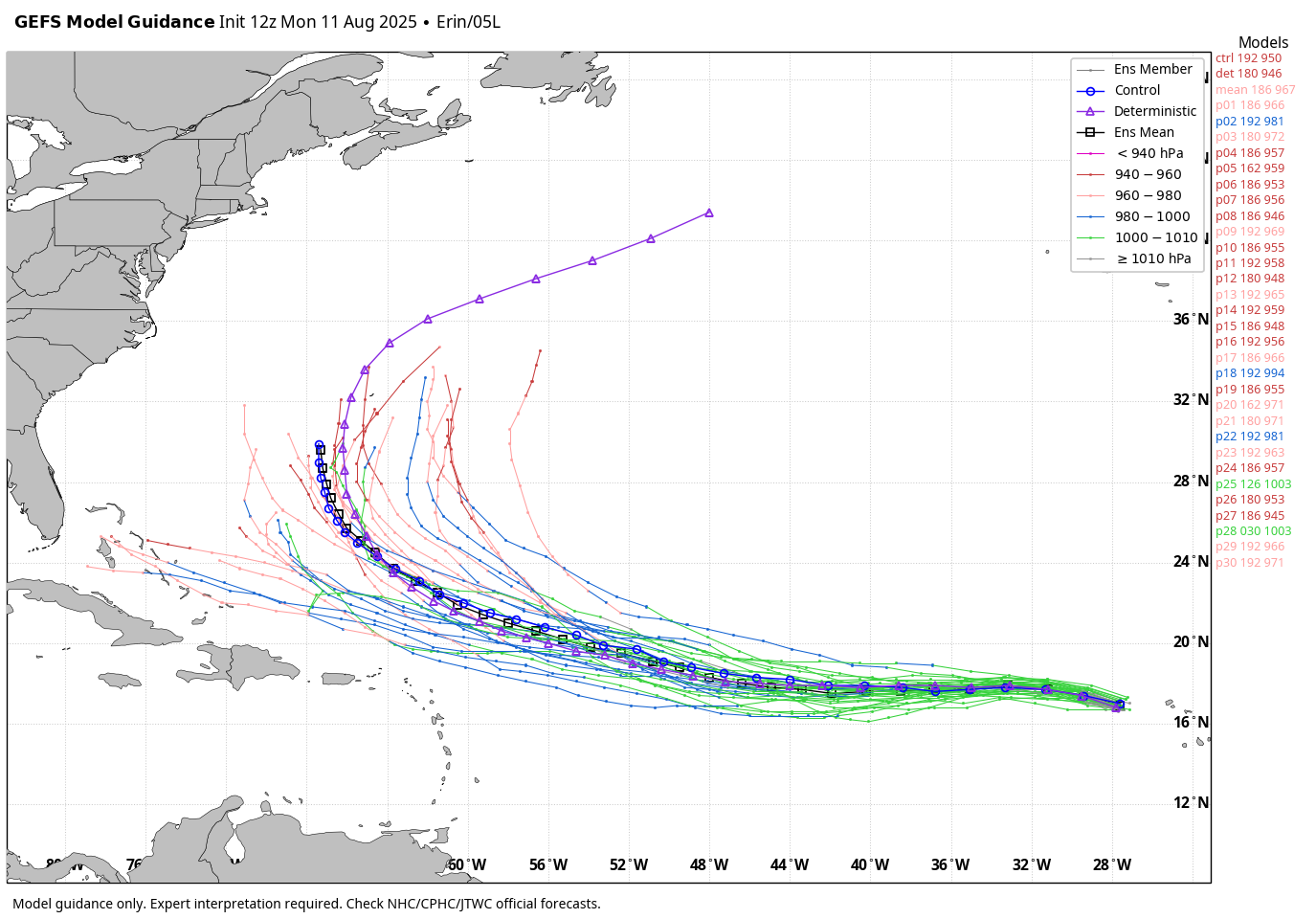
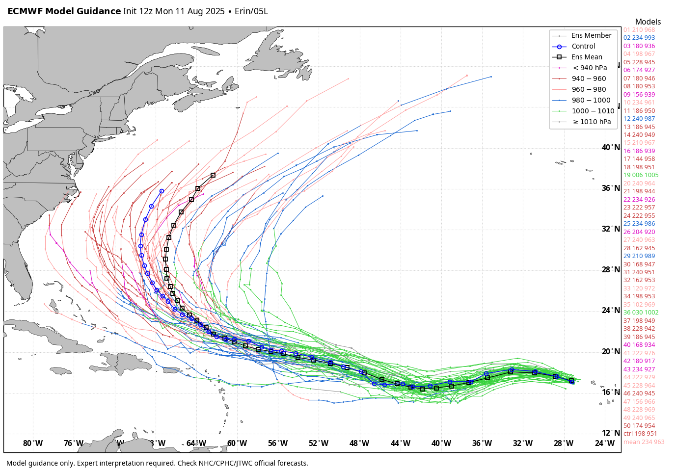
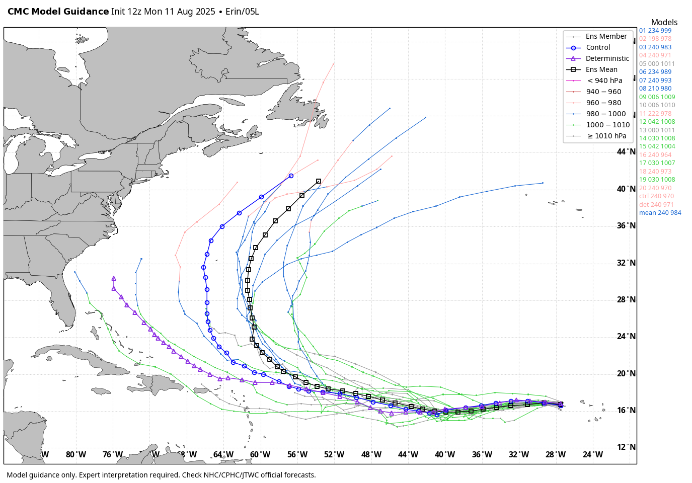
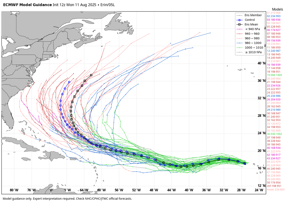
WB 12Z Erin ensemble runs.


-
Got back to North Conway and it’s 94. It was a crisp 79 degrees in Crawford Notch for about five minutes as we were driving on 302. Should have done the drive up Mt Washington it’s 68 at the summit.
-
 90 Heatwave #6 hopes stay alive
 -
 Leveled off at 89° here today as winds went onshore early this afternoon.
 - Today
-
I counted 6 of 30 (20%) 12Z GEFS members hitting the Conus. I’m not worried about it and am pretty optimistic the U.S. will not be hit, especially considering the climo related to the current 17.4N latitude so far E in the MDR. But though still small, 20% is the highest since at least 6Z of yesterday fwiw. Likely will go back down later runs today.
-
my torchy thermo spiked at 101. yes, i am sure that is 3-4 degrees high. but dayum it is still hot i am all set with the 90+ days. can I get something in the 75-80 degree range with lower dews, please
-
Some real dry air in NY… Saw SYR popped a 93/48 at one point.
-
BTV is at 95/56 for 27% RH. Pretty dry mid-90s for August.
-
Pretty much a perfect track for maximum wave impacts. The storm will be far enough offshore to not directly effect local weather (busy beaches) but close enough that swell decay is negated. Next week will be an interesting one at the beach.