All Activity
- Past hour
-
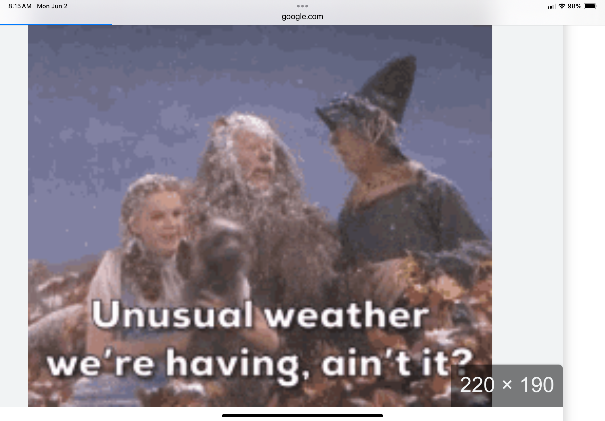
Hopefully that front is further north for you guys. But like tip said, has that ALB to PSM look.
-
Records: Highs: EWR: 93 (2000) NYC: 96 (1895) LGA: 94 (1989) JFK: 91 (1961) Lows: EWR: 48 (1946) NYC: 48 (1946) LGA: 48 (1946) JFK: 51 (2015) Historical: 1889 - A great flood on the Potomac River in Washington D.C. took out a span of Long Bridge, and flooded streets near the river. The flood stage reached was not again equalled until 1936. (David Ludlum) 1889: The same storm that caused the historic dam failure in Johnstown, PA, also affected Washington, D.C. The streets and reservations in the center of the city and all the wharves and streets along the riverfront were under water. Pennsylvania Avenue was flooded from 2nd to 10th Streets. The Potomac River crested at the Aqueduct Bridge at 19.5 feet on June 2. Additionally, damage occurred on Rock Creek, with the Woodley Lane Bridge washed away. Considerable damage occurred to machinery plants and material at the Navy Yard. 1917 - The temperature at Tribune, KS dipped to 30 degrees to establish a state record for the month of June. (The Weather Channel) 1949 - A tornado northeast of Alfalfa OK circled an area one mile in radius. (The Weather Channel) 1985 - Lightning struck a house, broke a bedroom window, and jumped to a metal frame bed. A man was killed but his wife was unharmed by the lightning. (The Weather Channel) 1987 - Thunderstorms spawned seven tornadoes in West Texas and six tornadoes in Illinois. Thunderstorms in Illinois produced wind gusts to 70 mph at McComb and Mattoon. Thunderstorms in southern Texas produced 5.5 inches of rain south of Seguin, and up to eight inches of rain in Washington County. (Storm Data) (The National Weather Summary) 1988 - Severe thunderstorms in Texas and Oklahoma produced hail more than three inches in diameter near Stilwater OK, and softball size hail in Jones County of north central Texas. Baseball size hail and 70 mph winds caused an estimated 100 million dollars damage around Abilene TX. (National Weather Summary) (Storm Data) 1989 - Thunderstorms produced severe weather across much of the south central U.S. through most of the day and night. Thunderstorms spawned a dozen tornadoes, and there were 123 reports of large hail and damaging winds. Thunderstorm winds gusted to 78 mph at Russell KS, and baseball size hail was reported at Denver CO, Cuthbert TX, and in Reeves County TX. Afternoon thunderstorms in southern New England produced wind gusts to 120 mph at Fitchburg, MA, causing five million dollars damage. (The National Weather Summary) (Storm Data) 1998: Frostburg, Maryland on June 2, 1998, at 9:45 PM - This was part of a killer outbreak of tornadoes that moved southeast from Pennsylvania. The storm entered Garrett County, Maryland striking the town of Finzel. It then moved up and over Big Savage Mountain in Allegany County and ripped through the northern portion of Frostburg. It reached its peak strength as it crossed the ridge. Winds were estimated between 210 and 250 mph (F4 on the Fujita Tornado Damage Scale). This was the first tornado to "officially" be rated an "F4" in the State of Maryland. The National Weather Service adopted the Fujita Damage Scale in 1973. The total damage path of the Frostburg tornado was over 25 miles long (8 miles in Allegany County) and up to a half-mile wide. Along most of its path, it was producing winds over 125 mph (F2 or stronger). The damage path was continuous as it moved up and down over 2000-foot mountain ridges. The fact that no one was killed in Maryland was attributed to 5 to 10 minutes warning that was well communicated to people in Frostburg over television, radio, scanners, telephones, and sirens. People took quick action to move to their basements. A mother and child rode out the storm as it destroyed their house hiding under a table in the basement. They were shaken but unharmed. A jacket from a Frostburg home was found 25 miles away. A diploma was found near Winchester, Virginia, 60 miles away and a bill was found near Sterling Virginia (about 100 miles away). 2008: Several supercell thunderstorms rolled southeast from northwest South Dakota into central South Dakota, bringing large hail, damaging winds, and flash flooding during the late afternoon and evening hours. The large hail, up to baseball size, and high winds killed a large number of birds, pheasants, and rabbits. The large hail also knocked out many windows and damaged the siding of buildings and homes in both Stanley and Hughes counties. Very heavy rain of over 3 inches caused flash flooding in many parts of Pierre into the early morning hours. A Federal Disaster Declaration was issued for Hughes and Stanley Counties, mainly for the flooding. (Ref. Wilson Wx. History)
-
Last dry Saturday was 4/19. brutal.
-

2025-2026 ENSO
40/70 Benchmark replied to 40/70 Benchmark's topic in Weather Forecasting and Discussion
I think it's prudent to be skeptical, but I am willing to entertain it.....I just think its folly to speak in absolutes and act as if its a forgone conclusion. -
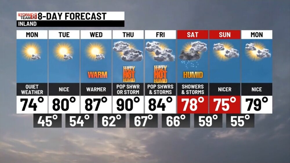
60 / 46 off a low of 43. Out of the cool/wet pattern and by tomorrow quickly to summer, Low 70s/mid 70s today - low 80s / mid 80s Tuesday and upper 80s to low 90s Wed - Fri / cooler coast.. 850 MB temps >17c Thu and again on Sunday could make a sneaky overperforming highs day pending on clouds/storms in between. Frontal boundary linger by Friday nigh - Sun AM so could see some pop up storms in the period and debris clouds Saturday (another weekend cloudy day potential). Sunday looks like the better day. Overall, warmer 6/9 and beyond.
-
Folks probably don't give a ratz ass how and why it rains on weekends at this point. The frustration doesn't care... But, I'm seeing this weekend's rain potential as more typically of summer - not being inundated with cold and NE flow type bs fwiw - There may be a warm/stationary front sort of stalled ALB to PSM type axis, like the current blend of the Euro/GFS, and associated rain/thunder ... More typical of 42 deg N latitude in early June. That set is up is normal synoptic frontal traffic this time of year. We get fronts... it's normal during both outstanding weather years, and piece of shit years, and all qualities in between. Cannot remove passing fronts, cool or warm, at this time of year. It would in fact be abnormal to have a big ridge anomaly with the westerlies and fronts all displayed way w-n ... If/when that ever sets up, that's more of a July and August thing. I get it that 12 weeks in a row of rain on weekends is some kind of maddening fractal ... I think the GGEM is full of shit... I'd take a blend of the Euro and GFS. If S of said axis above ... humid and warm with thunder in region. If your N of that, like Scott was saying ... rain intervals with thunder on Saturday. But mild-like. I would not take present depiction as gospel, anyway. The boundary could reposition N or S by 100 mb from this range.
-
Yes, 44 here as well
-
2025-2026 ENSO
40/70 Benchmark replied to 40/70 Benchmark's topic in Weather Forecasting and Discussion
It's also much easier to use any "forecast and analysis technique" with great success when you only go out three weeks into the future...start issuing an actual seasonal effort during the fall. I don't mean to be contentious or undermine your efforts, but if you are so confident in your analysis techniques and vision of where the globe is headed, then take it to the next level and do seasonals. -
2025-2026 ENSO
40/70 Benchmark replied to 40/70 Benchmark's topic in Weather Forecasting and Discussion
I don't think you are conceptualizing analogs correctly if you are waiting for one to "verify"....it's not about finding a replica season, it's about determining which analog seasons have value and what element of each analog season offers said value. I thought the 2013-2014 (favorable east Pacific with roughing over NE USA) analog held a great deal of value last season....as did the 1999-2000 (PNA interludes during cool ENSO and too little too late SSW) analog. 1972-1972 (Pacific cold phase competing with potent warm ENSO) was a very telling analog for the prior season. The reason that last season was warmer than 2013-2014 is due to a combination of a vastly different West Pacific and background warming. I thinking understanding how to use analogs is of increasingly of paramount importance amid a fairly rapidly changing climate. Its crucial when using analogs to understand that we are operating in a warmer base state, agreed. -
naso lucky today, getting plumed
-
Color me surprised. I've just accepted it's going to rain every saturday
-
i know this is late, but i was busy Saturday and Sunday. That storm Friday night was worse then any remanents from any hurricane that we ever had. I have never been nervous about the big trees in my yard as i was Friday, early Saturday. Its sounded like a Phucking freight train. The FD started going on calls around 1030, never stopped answering alarms until about 4am, The Enola area had so many trees and wires down more then i can ever remember in all my years as a fireman. So many transformer were blowing it sounded like a war zone and we were being bombed.
-
Month of May total 7.19" at my station. Highest temp 84f, lowest 46.
-
Bet we see those weekend temps bump up a bit
-
Great week coming up. Love to see those first triple H's.
-
…… and some innocent bystanders. As always ……
-
Got down to 44 here this morning. Happy Summer!
-

June 2025 discussion-obs: Summerlike
LongBeachSurfFreak replied to wdrag's topic in New York City Metro
Yeah 40 mph gusts are common on the beach front with the Ambrose jet. The strongest events I have witnessed in 26 years of ocean life gaurding is probably close to 60mph. I have a hand held anemometer so I’ll take some readings this week. -
What you need to do is adjust the thermostat to a number lower than 75 haha
-
2 weekends in a row ruined for good beach weather now. Can’t get it much over 70 on the shore before either clouds/rain or the 40mph Ambrose Jet. There are days where that wind approaches 50mph.
-
Another gorgeous chilly morning. Great sleeping weather with windows open and fans on. 49 in paramus, nj when i got to work this morning.
-
 17/7/3
 -
Where did you think you moved to? Seriously though, I don't know if you actually understood the climate in New England. There have always been hot days, this isn't Labrador.
- Today
-
I haven't planted my cucumbers yet. Too cold. My tomato plants look the same as they did when I planted them 3 weeks ago. Just a little more unhealthy due to cold nights. Potatoes and cannabis don't seem to mind cold windy springs.
-
Smoke ‘em’ if you got em’?