All Activity
- Past hour
-
@jonjon
-

First Legit Storm Potential of the Season Upon Us
CoastalWx replied to 40/70 Benchmark's topic in New England
I feel ok where I am for now. I’m hoping for 4” of heavy wet snow which would be great vs fluff. -
Absolutely gorgeous out there now with sunlight drifting through the snow laden trees, a mix of clouds and blue skies.
-
They posted it on there site lol
-
Were you summoned by @WxUSAFsaying warm nose? (BTW what went into choosing that name? Sarcastic irony?)
-

First Legit Storm Potential of the Season Upon Us
vortex95 replied to 40/70 Benchmark's topic in New England
Seem like w/ time, N&W of 495 is becoming the target max for Sunday. Compared to 24 hr ago when we were worried about if the pcpn shield would get any further N&W than TAN! Models are hurtin', global and mesoscale, recently. Can't recall so many issues in the short range! -
That's not far off the deck at all. Higher elevations in Howard, Carroll and Baltimore counties should be able to overcome it...hopefully.
-
One is trying to cut cost...less computing power = save $. Other is trying to actually improve the output. If you run the 500 pattern for last 3 days (starting 10 days out to where it is now), you can see the difference between the two. GFS (and even GEFs) bounces more so to speak. As @Holston_River_Ramblersaid, it's uncanny how little the thing bounces around vs everything else.
-
Jelly
-

First Legit Storm Potential of the Season Upon Us
dryslot replied to 40/70 Benchmark's topic in New England
Love the disclaimer for the RRFS...lol The RRFS A is a prototype NOAA run and not for decision making. It will post as available, and outages may occur. More RRFS details are available here. -
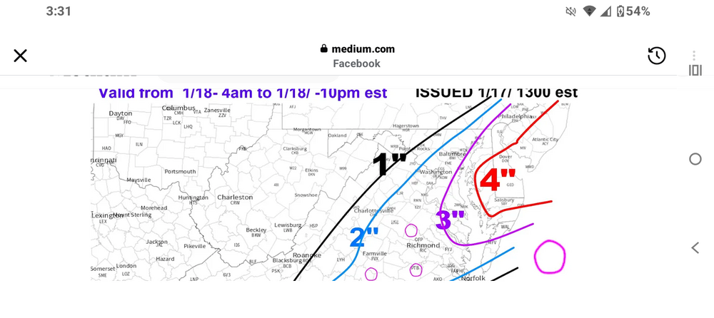
That doesn't look like a WxRisk map. There are no intersecting lines
-
Another Coating of Snow Saturday - "It's all we Got"
CoastalWx replied to Sey-Mour Snow's topic in New England
Let’s all have a region wide 4-8” pack. Lol -
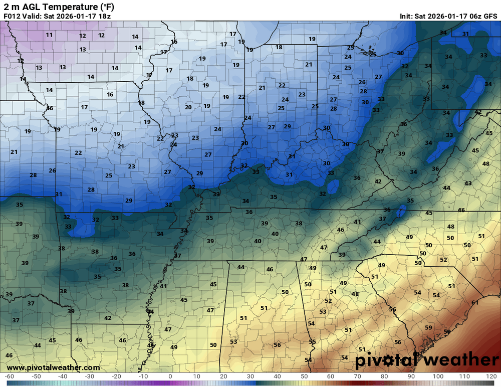
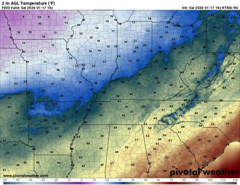
GFS at 18z (6z run) vs actual. Handling temps well so far, just a little too aggressive with the cold front
-

Central PA Winter 25/26 Discussion and Obs
canderson replied to MAG5035's topic in Upstate New York/Pennsylvania
One of the prettier days in recent memory. 42 now. Got some outdoor work down. -
It isn’t really the surface temps that are the problem on the NAM. 33-35 is ok at night with decent rates. But there’s a really annoying warm nose at 950mb.
-
1.7 here.
-
Honestly haven't even paid attention to this one
-

Another Coating of Snow Saturday - "It's all we Got"
LSC97wxnut replied to Sey-Mour Snow's topic in New England
Had a good burst of great dendrites of 1/2S while I was driving home from the store. Lightened up a bit now, but all grassy surfaces are coated. -
-

E PA/NJ/DE Winter 2025-26 Obs/Discussion
Chief83 replied to LVblizzard's topic in Philadelphia Region
Worcester, PA ended up with about 2.5". Normally not much of an event, but in this case the roads were horrible. I am not 100% sure, but it would appear not much brine was put down. It wasn't an issue of 15 degrees and brine not working. (I think brine has a point where it is too cold and doesn't work similar to salt). It was 30 to 32 degrees. It appeared after running four fire calls with in 2 hours it was township, county and state roads that were just a mess. (I'm in central Montgomery County PA.) I know the storm over performed, but I think we all knew there was a chance of snow. It also shows it doesn't take much of a coating to create traffic nightmares. I think I read most of the computer models missed it and only the RGEM performed better than others. Kind of makes sense to not put all your eggs in one model. Tomorrow we have a winter weather advisory - so we have a heads-up. Not sure, but I think brine has to go on a dry road. That does not appear likely today. In addition the locals are still plowing and not is a position to brine for tomorrow. Be fun to watch the models tonight for tomorrow. -
1/1: .3” 1/17: 3” season total: 9.3”
-
First Legit Storm Potential of the Season Upon Us
CoastalWx replied to 40/70 Benchmark's topic in New England
You guys looked like 3-5 at least anyways -
First Legit Storm Potential of the Season Upon Us
NotSureWeather replied to 40/70 Benchmark's topic in New England
Trend is your friend. Winters have been so bad that this storm would already make this winter better than the past few years. Southeast MA has been rough. -
First Legit Storm Potential of the Season Upon Us
CoastalWx replied to 40/70 Benchmark's topic in New England
Yeah, that was a nice over performer today. Been a while since we had something like that. -
Wxrisk's DT's forecast FWIW..