All Activity
- Past hour
-

New Years Day 2026 - 1st snows of the new year possible
SouthCoastMA replied to Baroclinic Zone's topic in New England
Rgem was advisory here. Let's ramp it up at 18z -
Reminder that it was supposed to torch this week.
-

January 2026 regional war/obs/disco thread
Brewbeer replied to Baroclinic Zone's topic in New England
as a rank amateur who understands little about weather forecasting beyond D2, it's the differentiating opinions, and the "arguments" around them, that I find most informative. -
While I’m certainly on board with January being another colder than normal month in the east, due to the front-loaded Niña we are in, which would fit the progression, that’s where I think it stops. At least that’s my thought right now. I’m not sure what BAMWX thinks about February and March? I know there’s some hype on twitter today about the new CFS being very cold in the east for the next 3 months; Jan, Feb and Mar….I just don’t see that happening. We haven’t seen a La Niña accomplish that (all 5 months in a row; Nov, Dec, Jan, Feb, Mar) being below normal cold in over 30 years (1995-96). That was a very atypical Niña, coming off an El Niño with a strong +PDO all winter long. As I said before, the only way I could possibly see that happening would be with a big, anomalous stratospheric shakeup like 2018 had. I guess we’ll see over the next few weeks
-
I mean, we haven't had a southern moisture storm in years now. It's sort of dropped off our radar since it's the middle of winter but the drought marches onward. I'm not sure why I'd expect us to magically start getting noreasters all of a sudden without a seismic pattern shift. Yeah there's always the fluke chance (per the GFS), but until the base state changes I think they're just fantasy storms.
-
Found this in the TN forum, looks like the SER is getting suppressed to the Deep South.
-

January 2026 Medium/Long Range Discussion
BTRWx's Thanks Giving replied to snowfan's topic in Mid Atlantic
Doesn't the cool pool help enforce a negative PNA? -
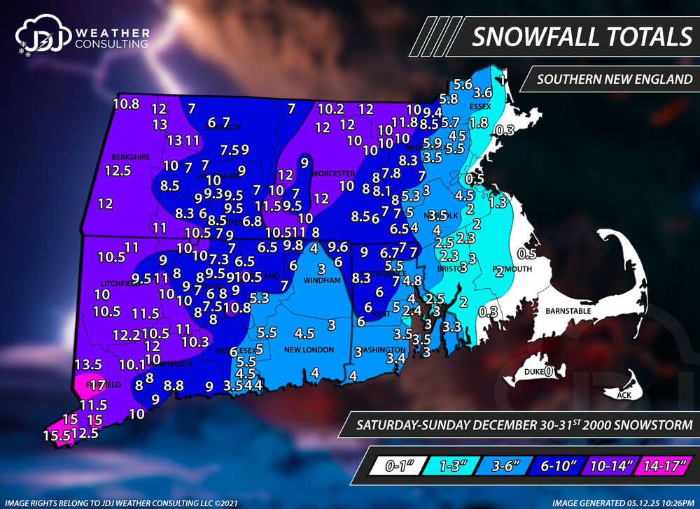
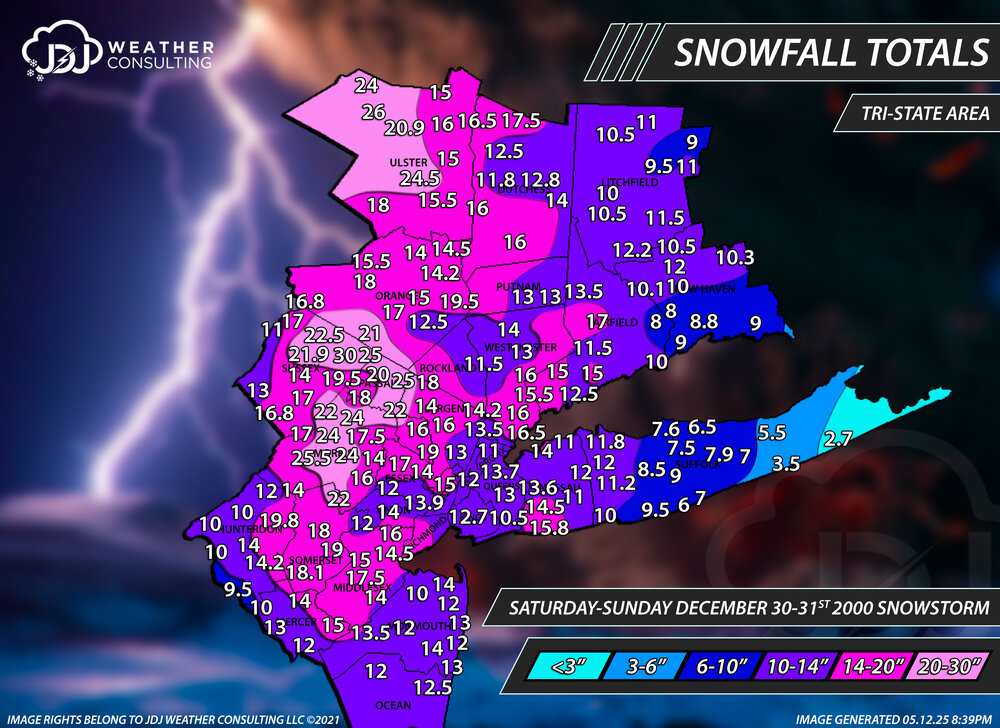
Todays the 25th anniversary of the December 30th, 2000 Snowstorm. I got a full radar animation up here and sfc loop. https://www.jdjweatherconsulting.com/dec-30-31-2000
-
My non expert opinion on the models is that it is related to climate change. They are struggling to be accurate because things are constantly changing and creating more variables than in the past.
-
A week or so ago we were talking about being back in the game by New Years or shortly after. Then it was the 8/9th. Now it's the back half of January lol. Pretty soon it's going to be hoping that a couple weeks in February delivers. Typical winter in the Mid Atlantic
-

January 2026 regional war/obs/disco thread
Typhoon Tip replied to Baroclinic Zone's topic in New England
I'm not in response there.. I was asking you, a question. His opinions can be where ever he wants. the point is, if you do no like him or his opinions, you have the power to do something about it - don't read them. In fact, if it bothers you that much, ignore him altogether. That's it. -
January 2026 regional war/obs/disco thread
Brewbeer replied to Baroclinic Zone's topic in New England
Al Gore invented lying too? And I thought his internet invention was impressive .... -
Well today has been crap. Maybe we can get Eric Webb to start honking about the SER so things can flip back to a big dog look.
-
January 2026 regional war/obs/disco thread
SouthCoastMA replied to Baroclinic Zone's topic in New England
which post? There are plenty of posts here that lack much meteorological reasoning behind them. From what I remember, he had meteorological reasoning but it triggered some of the ACATT folks because it went against narrative -
Paging @WEATHER53
-
You know if it was the late 1800s, and I had a ranch on the Plains...I would be thrilled with the warm weather. Why? Because without having to look at a weather model, I know that type of weather wasn't going to last!
-
 Save the itchy algae! changed their profile photo
 -

January 2026 regional war/obs/disco thread
Snowcrazed71 replied to Baroclinic Zone's topic in New England
Well, you didn't really need to respond to my post just to say this. My point is he's he's entitled to his opinion, but his opinions should be in the banter thread. That's all. Carry on -
Yep, exactly what you and I had discussed. Man, if this does transpire can you imagine the shock to the front range and Southern Plains ?! They've been dominated by that heat Ridge for a Couple Months for the most part. Denver is at Record level for least Snow at this Juncture.
-
The BIG question in my mind was this, "What happens after the Dec29-30th cold front?" I think a probable, and even likely answer, is now this. Dec 29-Jan10 is a transition timeframe as the eastern ridge retrogrades into the West. We get a TBD window where the EPO ridge just brings it. It would be hard to find a deterministic or ensemble run which doesn't end up here. The 12z EPS has that EPO ridge in place around 216, and then begins pushing a trough towards the east at that time. By 324 we get this -> The original window was Jan 8-10, and they may yet still verify. I would say the window is now Jan 12th, give or take a few days. Sometimes a big pattern like this is preceded by a big storm. Modeling across various products at 12z has a progression which makes sense given the analogs for this winter, recent Nina climatology, the QBO state, and...it is January - climatology fits. Good trends. Now, it is time to reel this look in. Get the pattern right, and then we can track. edit: Notice how well that tele connects? Cold in Europe. Cold in the East. HL blocking. Trough near Hawaii. Four quadrants of cold air. IF that builds, that could be tough to break down.
-
Thats pretty typical for modeling sites like pivotal weather.
-
January 2026 Short/Medium Range Thread
Save the itchy algae! replied to John1122's topic in Tennessee Valley
. -
I am heading there tomorrow morning for new years. [emoji1] .
-

New Years Day 2026 - 1st snows of the new year possible
weathafella replied to Baroclinic Zone's topic in New England
I really don’t like events like this. At least the most recent event prompted homeowners to clear and salt while these dinkleshit 1-2 inchers don’t get removed, everything stays icy until it rains or warms up otherwise, and makes for unpleasant walking conditions. Give me big storms followed by warmups and rain and I’m a lot happier these days. -

Pittsburgh/Western PA WINTER ‘25/‘26
colonel717 replied to Burghblizz's topic in Upstate New York/Pennsylvania

-

January 2026 regional war/obs/disco thread
metagraphica replied to Baroclinic Zone's topic in New England
On my watch list! In weather related news - it's windy, cold and cloudy outside, but at least the days are getting longer.


