All Activity
- Past hour
-
All-time March record set in Indy at 88 today.
-
5.5” at home, about the same at pleasant Back to winter for a few days, photo from earlier this morning .
-
Plenty of warm air coming. Ensembles show strong ridging in East.
-
-
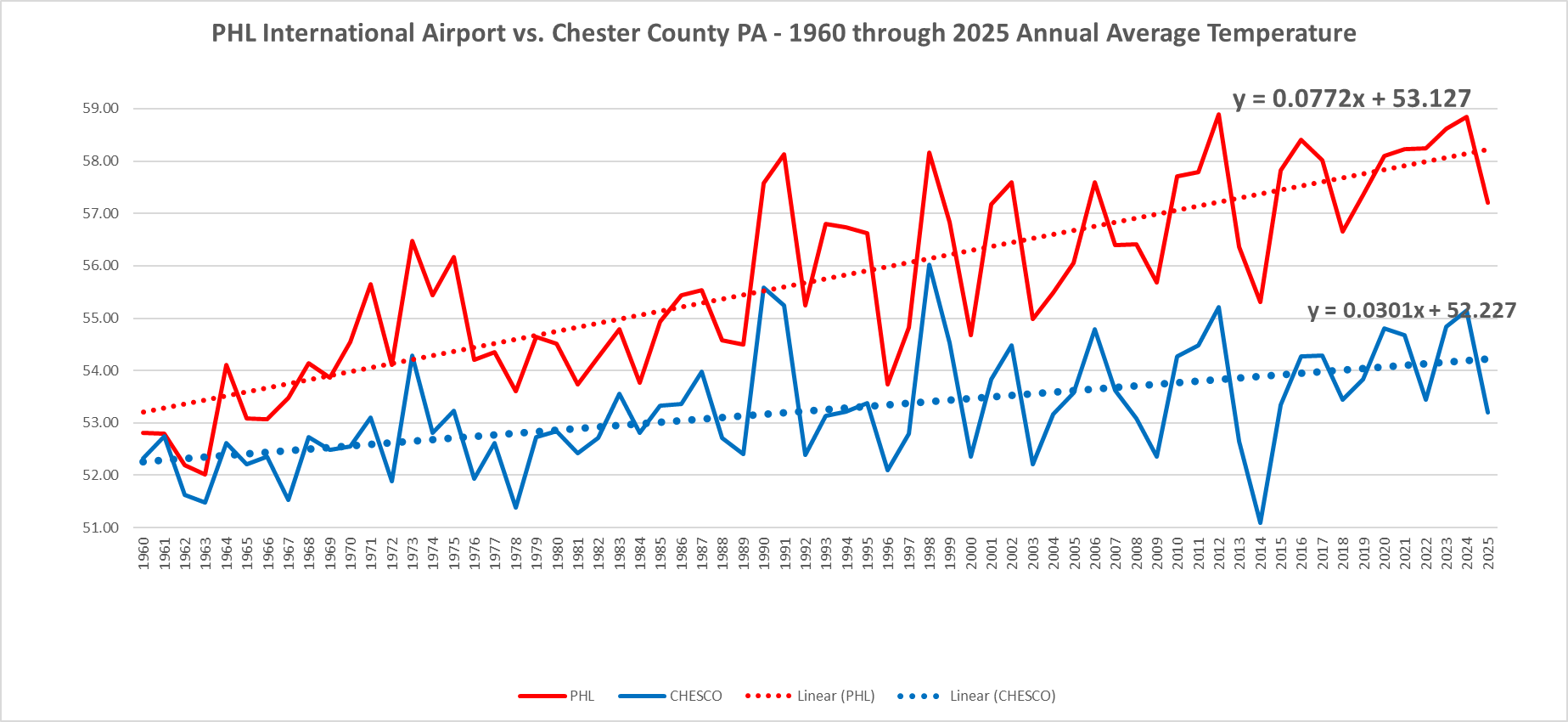
(002).thumb.png.6e3d9d46bca5fe41aab7a74871dd8af8.png) Below is how much faster the warming is just since 1960 at our local PHL Airport with their growing UHI problem. That warming slope is a wee bit different just around 25 to 35 miles west of the concrete and river warm oasis that is PHL Airport!
Below is how much faster the warming is just since 1960 at our local PHL Airport with their growing UHI problem. That warming slope is a wee bit different just around 25 to 35 miles west of the concrete and river warm oasis that is PHL Airport!
-

2026-2027 El Nino
jaxjagman replied to Stormchaserchuck1's topic in Weather Forecasting and Discussion
Some of these models especially the CFS has this for whatever reason are to amped when the Rossby Wave Train moves into the WP/MC.You dont seem to see these wind burst even pan out very well.The RMMS today seems to show this Rossby Wave further west than what they have been showing recently as some now show the MJO go back into the WP.It seems possible to me this Rossby Wave could strenghten the MJO signal into the Maritime/IO as we get into April
-
Oh, it sounded at the time like people were comparing dick sizes on which region was dealing with the bigger cold vs heat. I probably didn't get the gist of the conversation right - which I'm not about to scroll back and review. lol. Standard deviation would settle it among scholars
-

2026-2027 El Nino
michsnowfreak replied to Stormchaserchuck1's topic in Weather Forecasting and Discussion
Yeah. I mean you cant take winter forecasts with more than a grain of salt in Fall, much less spring. I was just pointing out sometimes colors look worse than they are. Milder winters mean nothing in terms of total snowfall here (as long as we avoid torch). Its about storm track or lack thereof. After two cold winters in a row with good snowcover but no impressive storms locally (largest was a surprise 6.2") my early gut instinct is that next winter sees less deep winter but a bigger storm, likely the biggest in 5 years or so. -
Chris simply does not see the current warming as an existential threat or anything to lose sleep over....as you know I agree with his view! This makes alarmists upset we all understand this!
-
Yesterday at DTW ended up hi/low 43/34 and today 55/35 with colder weather the next two days. Backdoor front ftw.
-
.thumb.jpg.6a4895b2a43f87359e4e7d04a6fa0d14.jpg)
Central PA Spring 2026 Discussion/Obs Thread
Yardstickgozinya replied to Voyager's topic in Upstate New York/Pennsylvania
The severe warned cell just east of orvistown is showing some supercell characteristics. -
Heck of a 12z euro. Big summer incoming
-
Yep it's called sleep inertia and can be crippling if you wake up from REM phase 3 or something
-
Some are likely shopping for a new computer, printer, TV, etc today. Happened to my parents last summer with an explosive nearby strike. Unplugging is a good idea when prolific lightning is expected as it removes the physical path for electromagnetic surges.
-
1-3” tomorrow morning ?
-
plus they get the power outage side of hurricanes
-
Yea. Also mid summer time we have fewer days interrupted by thunderstorms. They often stay to the west all day. It evens out.
-
I'll need to pack a track on our driveway with the car, or we don't get mail delivery. Gassed up the snowblower just in case, but unless we get 6"+ it will remain silent.
-
Its the trade off for more snow
-
You must be fun at parties
-
Thanks for the Mansfield snowpack updates PF – very informative and useful. Your last image in the series, which I copied above, is a great example of what I wrote about in my Bolton Valley report from yesterday. In your shot, you can see some spots where there are snow bridges across the gully, which are very easy to cross on skis. In contrast, if you run up against one of those sheer faces with multiple feet of snowpack like you see at the very front of your image, it’s a logistical nightmare to try to get across – both getting down into the gully and then trying to get back up out of would be incredibly difficult with a lot of wasted energy.
-
Made it to 51. Vomit worthy day. patterns like this Long Island more a New England climate than mid Atlantic.
-
Not bad for daytime accumulation in late March!
-

Central PA Spring 2026 Discussion/Obs Thread
mahantango#1 replied to Voyager's topic in Upstate New York/Pennsylvania
Severe Thunderstorm Watch SEVERE THUNDERSTORM WATCH OUTLINE UPDATE FOR WS 72 NWS STORM PREDICTION CENTER NORMAN OK 340 PM EDT SUN MAR 22 2026 SEVERE THUNDERSTORM WATCH 72 IS IN EFFECT UNTIL 1000 PM EDT FOR THE FOLLOWING LOCATIONS MDC001-023-043-230200- /O.NEW.KWNS.SV.A.0072.260322T1940Z-260323T0200Z/ MD . MARYLAND COUNTIES INCLUDED ARE ALLEGANY GARRETT WASHINGTON $$ SEVERE THUNDERSTORM WATCH OUTLINE UPDATE FOR WS 72 NWS STORM PREDICTION CENTER NORMAN OK 340 PM EDT SUN MAR 22 2026 SEVERE THUNDERSTORM WATCH 72 IS IN EFFECT UNTIL 1000 PM EDT FOR THE FOLLOWING LOCATIONS PAC003-005-007-009-013-019-021-027-033-035-041-043-051-055-057- 059-061-063-067-087-093-097-099-109-111-119-125-129-230200- /O.NEW.KWNS.SV.A.0072.260322T1940Z-260323T0200Z/ PA . PENNSYLVANIA COUNTIES INCLUDED ARE ALLEGHENY ARMSTRONG BEAVER BEDFORD BLAIR BUTLER CAMBRIA CENTRE CLEARFIELD CLINTON CUMBERLAND DAUPHIN FAYETTE FRANKLIN FULTON GREENE HUNTINGDON INDIANA JUNIATA MIFFLIN MONTOUR NORTHUMBERLAND PERRY SNYDER SOMERSET UNION WASHINGTON WESTMORELAND -
Central PA Spring 2026 Discussion/Obs Thread
Yardstickgozinya replied to Voyager's topic in Upstate New York/Pennsylvania
Thermo dynamic and kinematic profiles are finally growing throughout the area, better indices are also adventing into our area.