All Activity
- Past hour
-
Southern is an OK forum, I post occasionally, but I cannot stand the look and feel of the site. It’s brutal to me. There are good posters there and a lot of folks who post in both but I too wish we could get some back who’ve left here. It’s quite the spectacle to go over there if Raleigh is getting screwed by a storm. If you think the Raleigh folks here are bad it’s even worse there. They have a lot of Charlotte posters too which I appreciate as someone who lived there for a long time after college
-

Pittsburgh/Western PA WINTER ‘25/‘26
colonel717 replied to Burghblizz's topic in Upstate New York/Pennsylvania
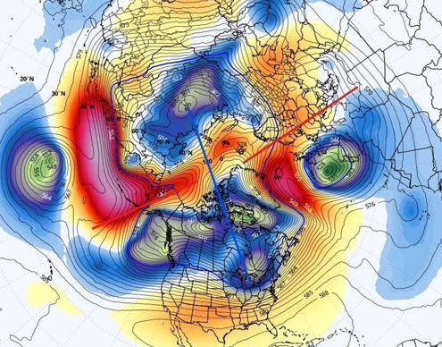
From Ohio Valley Weather Center: [Tue 12/16/25 215pm EST] Today I will focus on the upper-level pattern at 500 mb (18000 feet). While there is some let up, focus on the 500 mb heights. Notice the tendency for higher heights to start building up into Alaska and slowly spreading into Greenland. Here is the caption for Friday morning. Notice the dive of colder air into the area, whereas just a handful of days ago, this was not shown. Models missed this. (Inage 1) Notice another piece coming in for Sunday into Monday. A lobe of cold comes through. Another instance where the model missed this a few days ago. Now, it seems to be sensing colder air. Again, higher heights into Alaska and NW Canada and up into Greenland, a bit. By no means, perfect, but modest enough to dump a batch of cold air in the region, again. (Image 2) So, assuming models will indeed miss Friday and catching on now, then missing another piece Sunday/Monday, it is hard to trust models past a handful of days. So, while it will not be as cold over the next week to ten days, if models are struggling in the medium range, there is no reason to trust models past 6 or 7 days. The tendency is for the model to keep the vortex stretched across Canada and central and eastern Russia, which implies colder air to spill into the central and east. I believe the models are mishandling things, and each subsequent run, the models slowly catch something and once inside 3 or 4 days, you see the change.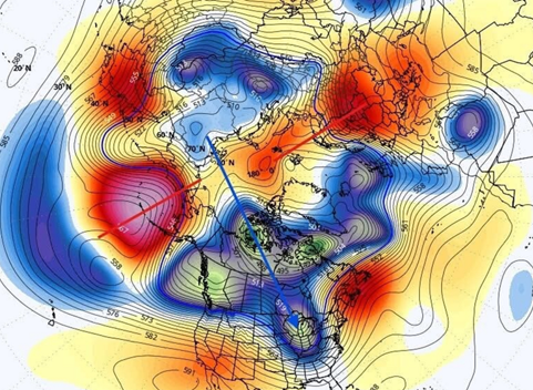
-

Winter 2025-26 Medium/Long Range Discussion
michsnowfreak replied to michsnowfreak's topic in Lakes/Ohio Valley
White Christmas looking unlikely. Bummer, but we've had snowcover the entire Christmas season to now, so thats been nice. After the holiday mild period, will be interesting to see if Jan-Feb takes on a classic nina like roller coaster pattern. With plenty of cold in Canada and plenty of warmth to the south, that may just be in the offing as we head deeper into winter. -
He’s still wrong though. GHDI was on the heels of prolonged cold. Maybe that one wasn’t so good for SE Michigan, but the problem wasn’t too much cold.
-
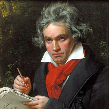
Uh-oh...guess what day it is? Guess what day. It. IS? Man this oughta be a global holiday On this day 255 years ago, the most consequential figure in the classical-romantic era was born in Bonn, Germany. The great Ludwing Van Beethoven...one of the greatest composers that ever lived. No composer singlehandedly brought about a new era of music quite the way he did. Beethoven was always a fiercely independent and determined man, and burst forth onto the music scene first in Bonn, and then in Vienna. He was a brilliant virtuoso whose talent quickly reached wide accalim. The musical world increasingly at his feet. But then...the malady that was so crushing hit him. BUT...after a near-death struggle coming to terms with his incurable deafness, Beethoven came out with a new determination: To express all the music that was within him. And he was determined to make music on his own terms. Because of the crushing affliction of gradually increasing deafness, among other trials, struggle and triumph permeate his music. And perhaps it is for this reason that his music still resonates so much today. His music was the raw expression of the human soul; all of it! And could this expression be fit into a musical box? It could not! Someone had to come along and open the door; and Beethoven not only opened it, he broke the whole wall down. No longer confined within certain walls, classical music was expanded to fully express what's in the soul. But in order for this to happen, somebody had to It is almost as if his struggle with deafness and a couple other physical afflictions. was the very thing that helped create the revolutionary music; that, combined with his sheer determination and fire, created music that forced the door open. As one documdrama ("The Genius of Beethoven") put it: With Beethoven, "music grew up". Everything Beethoven did tested the limits of instruments, musical form, and the very performers themselves. How things were done before could not contain Beethoven's music! His "new way", as he termed it coming out of his battle with accepting deafness, continued for the rest of his life...and gave birth to an entirely new era of music known as the Romantic Era. I could say so much more, but...his music touches me in a way nobody else's does. My soul identifies with Beethoven, and his music gives me thrills so much that anyone that knows me knows how I move when I hear any Beethoven work! He is the composer I revere the most--and I thank God for him! Happy Birthday, LVB!
-
He doesn't consider 6-9" a big storm lol
-
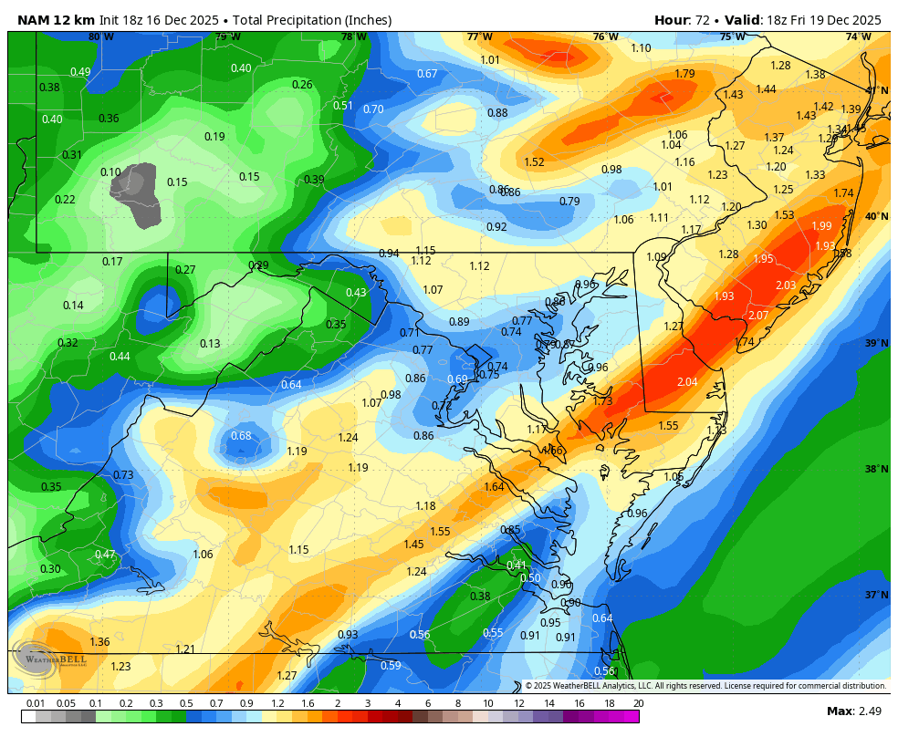
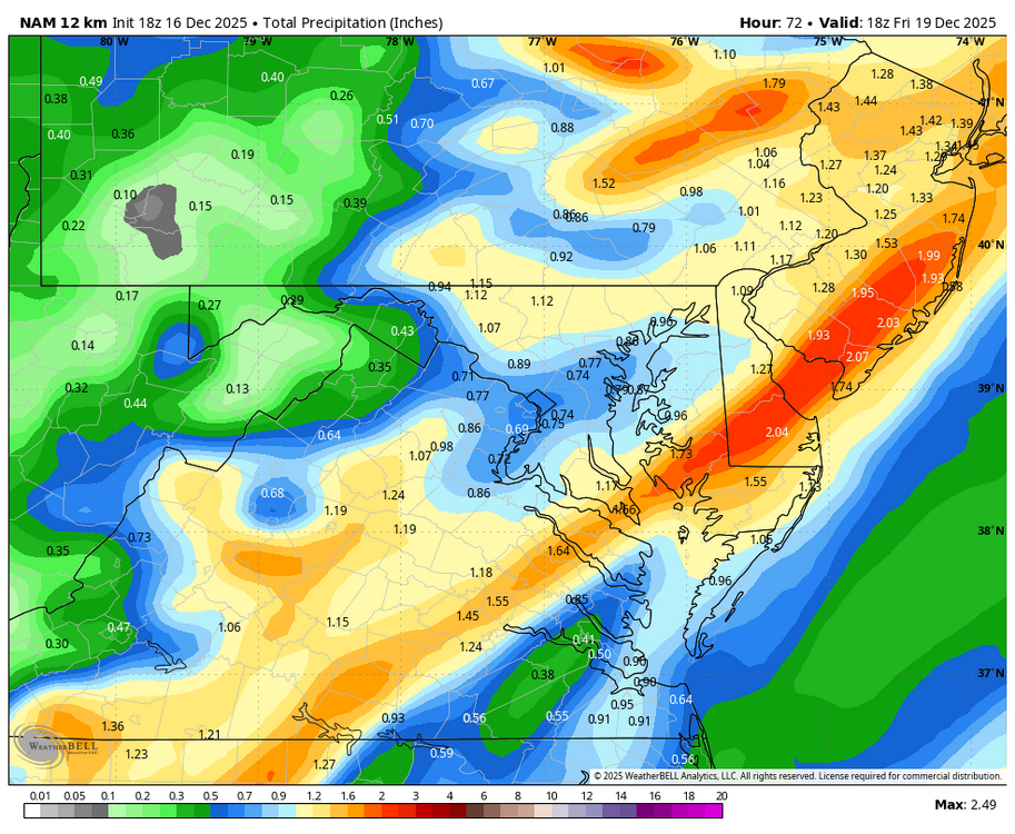
Wet Thursday evening and Friday am on tap....wash the salt away. WB 18Z 12K NAM
-
Yep. The only exception I can think of is one of those late season stalled fronts where it’s shorts weather to the south and waves of snow a couple hundred miles north. It isn’t the right time of year for that. It’s late Feb through early April for that kind of setup. Mid-winter big dogs need that arctic air nearby, usually to the NW.
-

December 2025 regional war/obs/disco thread
SnowGoose69 replied to Torch Tiger's topic in New England
As long as Canada stays cold this flips quickly if the PNA goes positive if the other indices largely remain where they are. If somehow though we get a week or 2 of a GOA vortex we're probably done til 1/20 at least. No signs of that though -
Those Euro weeklies are horrendously warm!
-

December 2025 regional war/obs/disco thread
40/70 Benchmark replied to Torch Tiger's topic in New England
Pattern update. https://easternmassweather.blogspot.com/2025/12/mid-month-warm-up-arrives-on-schedule.html -

December 2025 Short/Medium Range Forecast Thread
Golf757075 replied to John1122's topic in Tennessee Valley
I think a true pattern change will take place when the mjo starts to move. Takes a while to get out of warm patterns if they become established imo -
It will be quite the spectacle to see what wins out. The raging Pacific or growing -AO/-NAO
-
Winter 2025-2026 Offers Return to Normalcy
40/70 Benchmark replied to 40/70 Benchmark's topic in New England
Mid-Month Warm Up Arrives On Schedule Path to White Christmas Remains Despite Friday Grinch December Forecast Largely On Track Thus far the month of December has behaved largely as expected, primarily owed to the similarity of the anticipated deviation from the predominate Maritime Continent forcing of the past decade, to the analog periods of December-January 2017-2018 and 2024-2025. December 1-13 2025: December 2017-January 2018: December 2024-January 2025: The primary differences being that this month has been more extreme in terms of the magnitude of negative temperature departures, possibly owed to the extreme Bering Sea blocking (-WPO) that has been observed (-3.48 WPO peak on 12/13). The polar vortex disruption that occurred late last month has behaved remarkably similar to the early December 2000 analog event in that it fell just shy of triggering a full 850MB zonal mean wind reversal in the arctic. This has afforded the vortex the opportunity to recover to something that will approach climo levels by the holiday week, as forecast last fall per research conducted Lee et al (2019), which indicates that the arctic high regime is favored for less than 20 days following a weak PV (roughly November 28th). This despite the insistence of initial modeling and social mediaologoists alike that it would remain weak through the new year. This consistent recovery following the lack of a zonal wind reversal has allowed the high latitude blocking to relinquish it's grip by mid-month, as forecast. The increasingly hostile polar domain in conjunction with lowering heights on the west coast as reflected by a descending PNA value will allow the storm track to shift west just in time for the expected "Grinch Storm" this Friday, which will eradicate all of the snowpack throughout southern New England. This is event is similar to periods prior to the Christmas holiday in the referenced analog months of December 2007 and 2008, especially the former. Thereafter, there is going to be a battle waged throughout the holiday period as the MJO remains shallow and variable, while the Pacific Trough regime begins to assert itself. White Christmas Odds Perilous As Pacific Trough Regime Establishes One of the primary assertions made in the Eastern Mass Winter Outlook last fall was that the aforementioned recovery of the polar vortex and persistent RNA pattern would team up to induce a Pacific trough pattern during the second half of the month, as a potential pre-cursor to a January stratospheric reflection event. Current long range guidance now reflects such a pattern. While the forecast for the balance of 2025 would appear rather unchallenging, things are seldom as they appear in weather. In this particular instance, the caveat is an MJO wave that is expected to remain rather meager and variable after having largely dissipated over the course of the past week following its brief flirtation with phase 8 near the outset of the month. This disjointed signal will allow an occasional element of west Pacific expression to assert itself into the pattern as a byproduct of areas of dual forcing, especially into the final weak of the month, which will allow for some potential colder intrusions into the northeastern quarter of the country. Christmas Eve 500mb depiction per EURO Weekly product, EURO ensemble package, GFS ensemble and Canadian ENSEMBLE. Having a supply of cold near by means that the likelihood of a white Christmas across the southern New England forecast area, while unlikely after the visit from the Grinch on Friday, can not be discounted since there may be some weak northern stream energy passing through in the vicinity of the holiday. There is also some suggestion amongst guidance that Scandinavian blocking could develop by the New Year, which could represent a precursor to an episode of some Greenland Blocking prior to the development of any subsequent refection event later in January. Although the pattern is unquestionably turning milder on average, it would be advisable to stay tuned for updates as the all important holiday period approaches because the devil is often in the details. -
Beer?
-

December 2025 Short/Medium Range Forecast Thread
Carvers Gap replied to John1122's topic in Tennessee Valley
Yeah, cold and viruses have been making laps in my crew. Pretty miserable stuff and hangs on forever as @Daniel Boonenoted. Hopefully the 12z Euro Weeklies are right and we see cold return right after mid-January. The 12z CFSv2 breaks for cold at about the same time. It looks like when the NAO fires(if it fires), that puts a clock on the chinook. Maybe if that NAO can fire earlier, we can return to a colder pattern more quickly. But really, I am good with a couple of weeks of warm weather. Something makes me think the dam is gonna bust at some point sooner than later. One good cutter, and it could all come south. -

Winter 2025-26 Medium/Long Range Discussion
A-L-E-K replied to michsnowfreak's topic in Lakes/Ohio Valley
unrelenting pac jet ftw there -
.
-

Winter 2025-26 Medium/Long Range Discussion
TheClimateChanger replied to michsnowfreak's topic in Lakes/Ohio Valley
Wow, that's a lot of rain on top of the ongoing flooding in the Pacific Northwest. -

December 2025 regional war/obs/disco thread
WxWatcher007 replied to Torch Tiger's topic in New England
Sometimes the writing is on the wall (last year), but we’re in a different position this year. We have to get lucky, but we’re at least in the game for something next week. Like Steve said, we’re wired to want a white Christmas. We could be in the Midwest with absolutely no hope. -
the human body acclimates remarkably quickly.
-

Winter 2025-26 Medium/Long Range Discussion
Malacka11 replied to michsnowfreak's topic in Lakes/Ohio Valley
Abused By The Weather: A Report on Trauma Responses and Grief Processing Stage Indicators Based on Online Hobby Weather Forums -
while i grow to hate cad more each passing year, you really do need deep cold nearby for the big dogs that really crank
-
Won't they have to get the Bob houses off before the rain? Most of the ice will be gone.
-
The refrigerant under the ice will be fine no matter the ambient air temp.