All Activity
- Past hour
-
Thanks
-
Yesterday that looked more plausible. Today's indicators more tamed to seasonal+ But you're putting up charts that are upper 80s... as a support for you 90+ Do you see the logical problem there?
-
Looking at some significantly warmer periods coming up but should be active with the fropas too. However, the theme should be much different than we've seen with cool dominating. Should be warmer days winning out with a day or two of cooler temps post fropas
-

2026-2027 Strong/Super El Nino
snowman19 replied to Stormchaserchuck1's topic in Weather Forecasting and Discussion
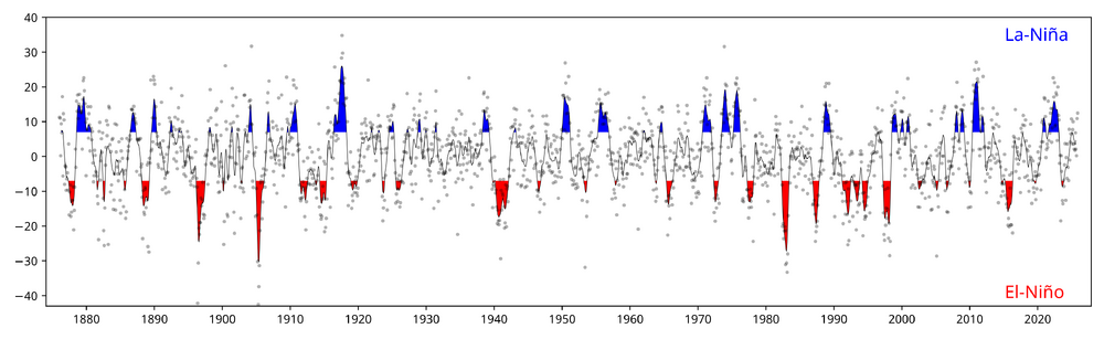
Agreed. Considering that is only the forecast through October and it will still be strengthening/warming at that point (the models have it peaking in November/December), with the added warming, it would almost certainly tie if not beat the all time RONI record since 1950, which was 1982-83, with 1997-98 being the 2nd. And it would also beat the record traditional ONI since 1950 -
SNE and a neighborhood near you
-

Central PA Spring 2026 Discussion/Obs Thread
WmsptWx replied to Voyager's topic in Upstate New York/Pennsylvania
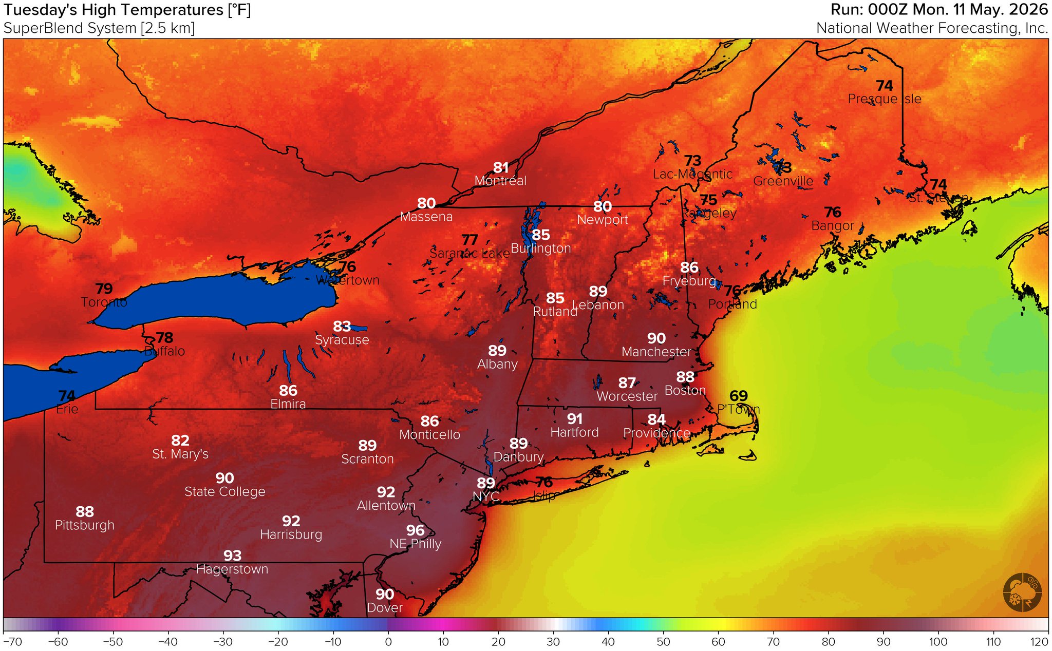
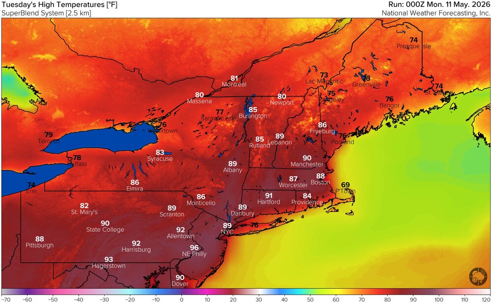
Euro shows Philadelphia flirting with the century mark this weekend. -
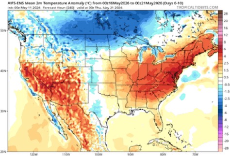
55 / 32 after a high of 80 yesterday. Cool next 5 days with clouds / showers the theme. Upper cutof low moves through Thu - Fri. Brunt of rain 0.5 - 1.00 in the wettest case is Wed - Thu and Fri. By Saturday moderation to a warmer period is beginning. Much above in the 5 /17 - 5/24 >80 / next 90s with peristent ridge/warmth beyond there.
-
Maybe in the lower Ohio Valley…
-
Still winter until ~ the 13.5th to the 15.3rd ... Just beyond, obvious wholesale changes to this side/continental hemisphere would likely change the correction vectors from defaulting cooler to defaulting warmer - more of a behavior argument. The actual outlook itself moves temperature needle from averaging these 64/33s, to 76/51s ish (with option for more or less depending on alpine vs lower els) in the dailies. As an afterthought ... we have enjoyed some 8 consecutive months of suppressing warmth over our local Meteorological/geography. Really since last autumn, this has been an amazing sabbatical from the responsibility to objective awareness ( LOL ). A time in which we've been enabled to forget certain tendencies ... one of which, if the pattern is 'warm', the warmth always overperforms - at least to some degree. Suppression of that specific behavior. A hint to that being the case? We've put up modest positive anomalies, despite cool pattern persistent complexions. Another interesting observation (for me) that betrays that "lie", our monthly means are less than the 2nd to 3rd warmest 8 months in Global climate history, spanning the last half year: we've been in a persistent offset region. It all goes away when the cooler hemispheric curvature biases finally decays... With the advent/onset of an aggressive ENSO guard change coinciding with seasonal change, this at least intuitively would be a good time to see that happen, and to at last escape this winter's instilled recency bias. So, with this pattern that appears to be higher confidence ( post the 15th)... that will yield warmer than the current mere seasonal look - trust me. How much so? ... yesterday there was a bit of a heat wave signal. That appears to less so for that moment - unless you're a GEPs fan, which I'm not. But life outside the resonant cool pattern of the recent year appears favored.
-
On 5/10/24 this happened:
-
Fringed so far in southern moco but hoping it spreads further north in this incoming stuff
-
Had 0.48" in gauge at 7 am CoCoRaHS reading, another tenth in gauge at 8 am. Currently light rain and 53.3/52.4. Wasn't raining at 2 am when I went to bed but was when I woke up at 6 am.
-
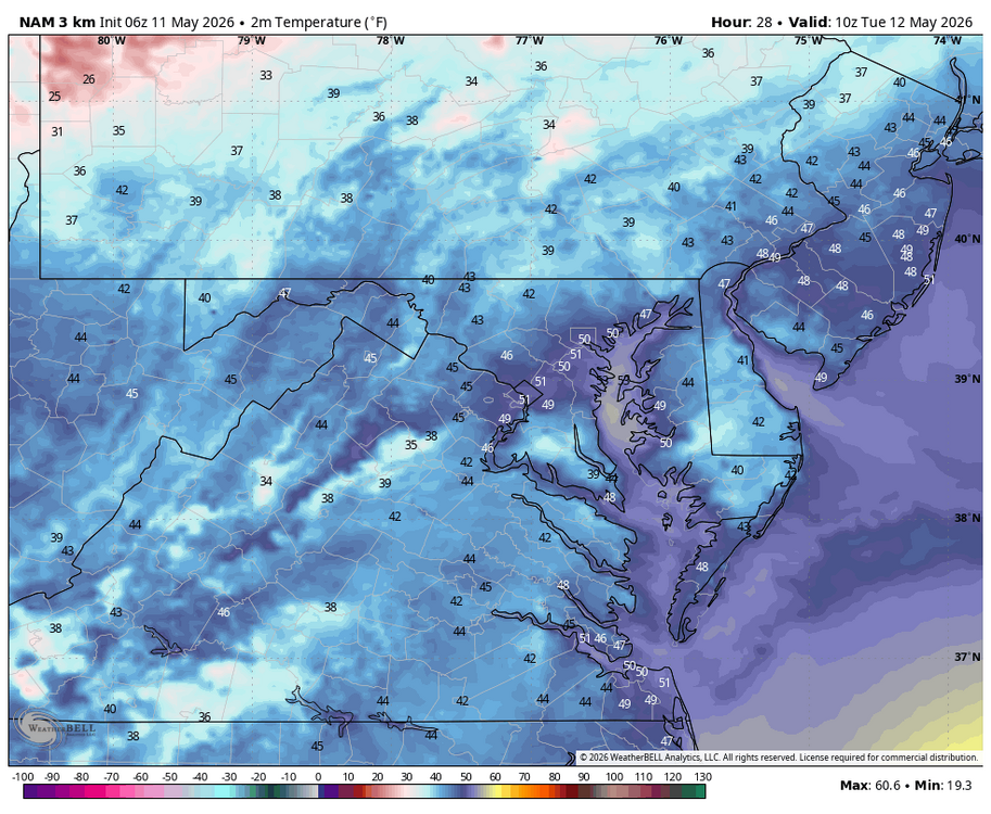
WB 6Z 3K NAM. Chilly overnight with freeze watch for highest elevations. Note latest NAM is a tick warmer.
-
I had one brief shower pass through and am watching and hoping for the good-looking stuff on radar heading in. We need this bad!
-
Let’s get these clouds out of here this morning.
-
Summer begins Saturday ! The few uninstalled’s , better install . 90+ next week
- Today
-

2026-2027 Strong/Super El Nino
bluewave replied to Stormchaserchuck1's topic in Weather Forecasting and Discussion
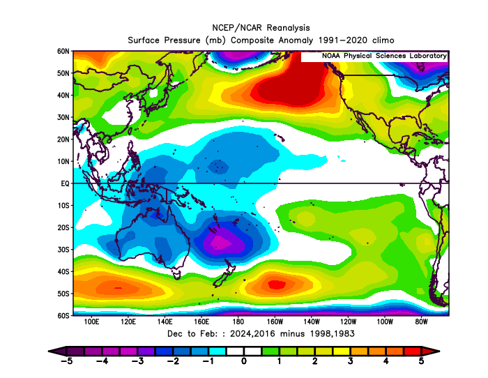
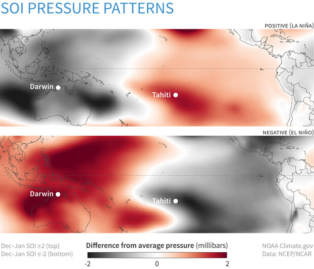
It’s probably a function of the expanding WPAC warm pool distorting the pressure pattern associated with the SOI. The SOI has been becoming more positive since 1980. During the 2023-2024 super El Niño, the SOI was only weakly negative compared to earlier events. Even 2015-2016 never matched the SOI lows of earlier events like 1997-1998 and 1982-1983. More challenging to get the record -SOI levels of the earlier days with the lower pressures in Australia and warmer waters.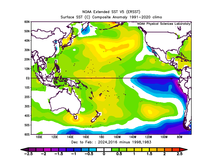
-

Winter cancelled/uncancelled banter 25/26
donsutherland1 replied to Rjay's topic in New York City Metro
The Washington Post has a feature story concerning prediction markets. Far from this form of betting providing insight into the future, the Post's article suggests manipulation through massive numbers of automated transactions of 1 million or more transactions (roughly one every 3 seconds). If so, the prediction value is limited, as perceptions are created to back a given narrative disconnected from actual probabilities (an issue that is much less present in large, deep markets where handfuls of accounts lack the capacity to manipulate prices in most cases). As transactions in any buying-selling decision influence prices, these automated trades almost certainly have a price impact and, in the process, give their users a qualitative advantage by creating a skewed perception about the future. Not mentioned, but also a consideration, is the possession and use of inside information. Examples where such information might have been involved range from large trades shortly before President made tariff-related announcements e.g., postponing their implementation, and the recent military operation to remove President Maduro from Venezuela (one special forces soldier involved in the operation had placed large bets). One image from the piece: The full story can be found here: https://wapo.st/49o6Jxc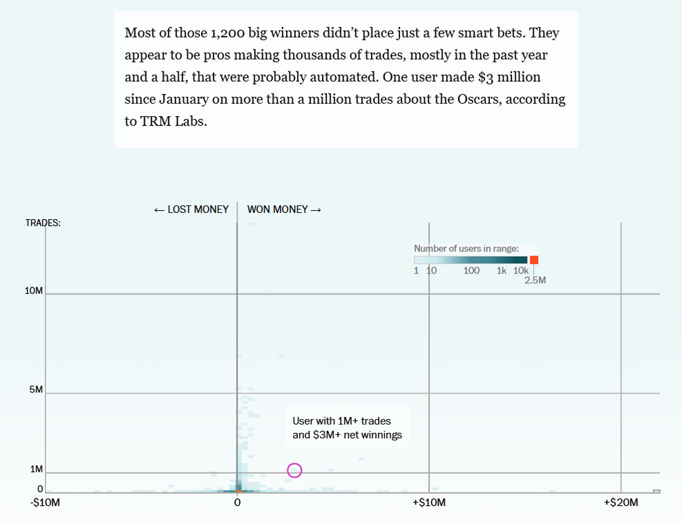
-
Wow! Radar looks surprisingly good for PG, AA, DC, and southern MD.
-
Hopefully, the developing El Niño can ease these historic drought conditions across the CONUS.
-
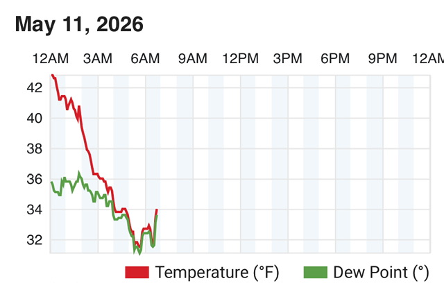
Frosty morning with 32F min.
-

E PA/NJ/DE Spring 2026 Obs/Discussion
Hurricane Agnes replied to PhiEaglesfan712's topic in Philadelphia Region
Over the weekend down here, one of the popular pick-your-own places in the area- Linvilla Orchards in Media, Delaware County, had announced that they lost 90% of their apple crop and somewhere around 60% - 90% of their peach crop after that last freeze. I know those 2 are probably their biggest fruit products in terms of tree planting, popularity, and sales... although they also have plums, nectarines, cherries, pluots and apricots (that IIRC tend to bloom earlier), plus they have the bush fruits like blueberries and raspberries and viners like strawberries. Still , that was a huge loss for them and illustrates how farmers have to deal with fickle weather. I finished up April with 2.68" of rain and over the past week since May 6, I've had 0.95", the latest with 3 rounds yesterday of 0.28", 0.21", and 0.01" just before midnight, with another 0.01" today just after midnight. I was able to get under a couple of tiny convective cells yesterday that triggered my lightning detector, but didn't produce any audible thunder. Still, it was my first convection of the year! Got up to 78 yesterday after a 48 low and am currently at an overcast 50 with dp 38. -
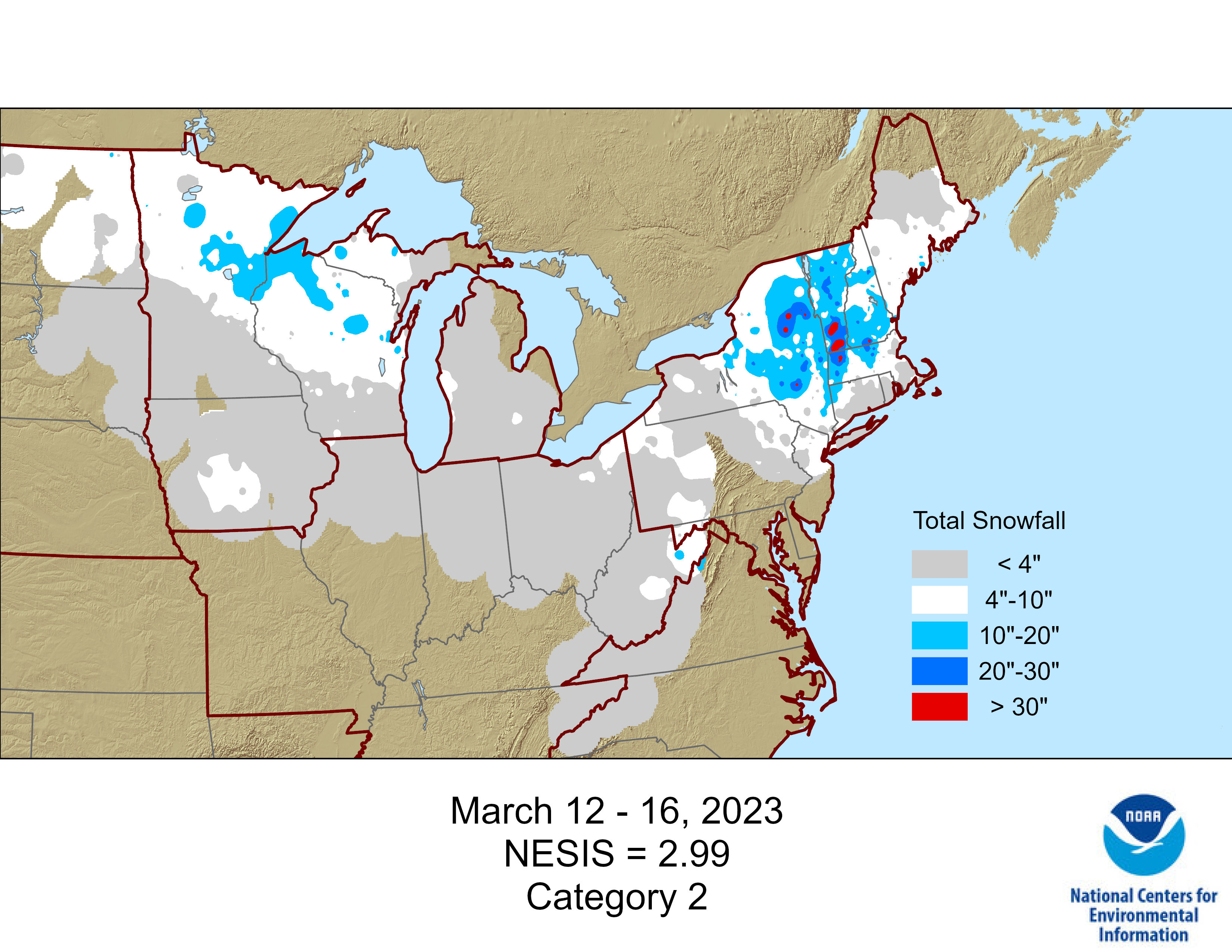
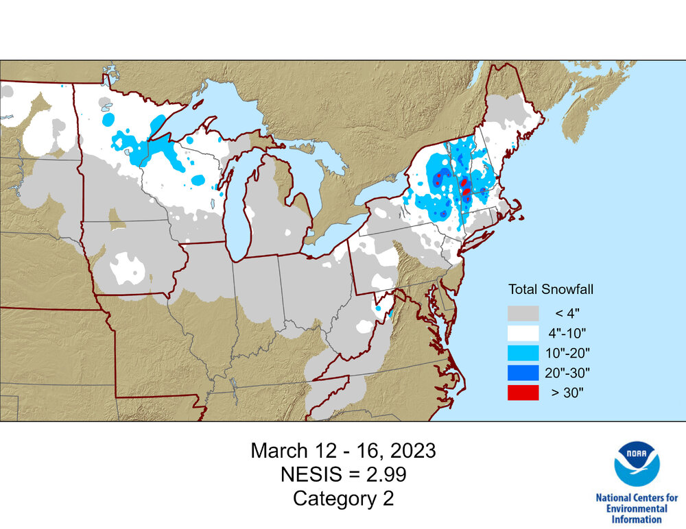
This event was recently added to the NESIS list as a cat 2 w/snowfall map. Pretty sure they added in when they did Jan 2026, last i checked the most recent was Dec 2022.
-

Winter 25-26 (All Snowfall Maps & Season Total)
512high replied to The 4 Seasons's topic in New England
Nice work! -
I wouldn't mind a whole summer with the dewpoint never topping 60.