All Activity
- Past hour
-
 Sey-Mour Sleet!
 -
 His account is messed up for some reason, not intentional
 -
WOW....near whiteout here!
-
I had risen to 53 ironically during that heavy band of rain but have fallen back to 45 currently.
-
Turned to ice pellets about 2:15. 8.25 inches. 18.8 degrees.
-
 Getting destroyed right now.
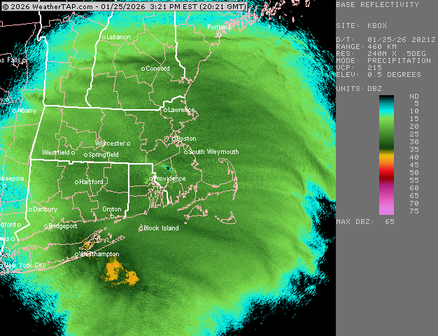
-
 This shitty snowgrowth in what appears to be good banding is a real bummer.
 -

January 25-26 Winter Storm Potential
Ej257 snow lover replied to Ralph Wiggum's topic in Philadelphia Region
Back to moderate snow in nazareth. Dont see much sleet at all mixed in. -
 All sleet now
 -
Just hit 2" of sleet for the day. 6.5" otg 7.5" total frozen and temp is falling. Lost 2 degrees in the past hour or so.
-
Heavy sleet 19 degrees how is this possible?
-
This is the heaviest sleet I can remember since I was a child in like 1992 I believe? I remember the ice being so thick on the snow top that I could walk on it and push around my big tonka trucks without it sinking down.
-
 It's nice to be on the warm side of the front and have it at 17*.
 -
.thumb.png.4150b06c63a21f61052e47a612bf1818.png) A little under 7” total today so far, + SN. 8° no wind
A little under 7” total today so far, + SN. 8° no wind -

January 25-26 Winter Storm Potential
jrodd321 replied to Ralph Wiggum's topic in Philadelphia Region
Drifting everywhere in my backyard. 11” official on driveway. Should pick up another few inches of sleet/snow throughout the night. What a storm ma. -

Southern Crippler - Get well soon Jimbo Storm Obs
WXNewton replied to BooneWX's topic in Southeastern States
Pouring sleet! -

Central PA Winter 25/26 Discussion and Obs
CarlislePaWx replied to MAG5035's topic in Upstate New York/Pennsylvania
At 4:00pm here in Carlisle...with light sleet continuing to fall...the temperature is 12.4 degrees and the dewpoint is 9.1 degrees F. During the past hour no pure snow was seen. The light sleet was compacting upon itself, thus negating a measurable increase in the storm total. This is the first hour during the storm that no additional sleet and/or snow was recorded. Let's see what the next hour brings. This will be the final hour of total daylight. -
Latest discussion: https://www.spc.noaa.gov/products/md/md0064.html
-
Outside my window in Arlington VA, ice pellets are starting to stick to the topside of branches. This may suggest they were partially melted, and refroze on contact. Something is STILL falling, and I think it all got to be a bit much for those trying to clear the path from their front door for the first time today. Visibility is better, but still not great. I just checked the NWS website that is reporting 1.25 mile visibility at DCA.
-

January 2026 Short/Medium Range Thread
Holston_River_Rambler replied to John1122's topic in Tennessee Valley
Storm vista models. 20 bucks a month for the usually models too, but they generally populate model frames the quickest. Not quick enough to be worth 20 a month on top of weatherbell usually. I might do it next month for one month to see how weathernext does though. -
This is an epic event wow 99% heavy sleet 1% glaze in annapolis .
-

Central PA Winter 25/26 Discussion and Obs
Blizzard92 replied to MAG5035's topic in Upstate New York/Pennsylvania
Yes, wonderful resource! This has been my main tool tracking the storm all day. Looks like the sleet line pushed all the way north to almost Lewistown... -

Extreme Cold, Snow & Sleet: SECS 1/24 - 1/26
jm1220 replied to TriPol's topic in New York City Metro
Needle flakes that aren’t piling up much but yes. Enough to reduce visibility. -
 I was referring to CoastalWx's temp in Marshfield and the Marshfield Airport. BOS was a reference point as it was warmer there than the 17 reported in Marshfield.
 -
Looks like the coastal is robbing the moisture from Western LI right now. Lighter echoes, while to the west NE NJ continues to absolutely crush. Someone will get 2 feet around there. Down to 19.7 WTF