All Activity
- Past hour
-

September 2025 OBS-Discussion centered NYC subforum
SnoSki14 replied to wdrag's topic in New York City Metro
Unfortunately the slowly boiling frog in the pot applies here. Until we see undeniable catastrophic daily events globally then most will ignore it. Won't be long though. With current trends we'll see multiple unlivable conditions develop in a decade or so. -

2025-2026 Fall/Winter Mountain Thread
Maggie Valley Steve replied to Buckethead's topic in Southeastern States
We're getting showers in the Valley now. Heavier rain looks likely for some.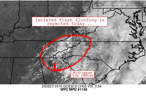
-

2025-2026 ENSO
PhiEaglesfan712 replied to 40/70 Benchmark's topic in Weather Forecasting and Discussion
I'd say the unlucky pattern started after the 15-16 el nino. The only real KUs since then were the January 31/early February 2021 and late January 2022 ones, and even those didn't bullseye my area. It was a combination of things that caused it, but you could start to see the cracks forming as early as 11-12. 13-14 and 14-15 were the last real sustained winters. 17-18 was a good cold season, but you had two random record warm months, in October and February. -

September 2025 OBS-Discussion centered NYC subforum
the_other_guy replied to wdrag's topic in New York City Metro
I dont think most people deny its happening. I think beyond headlines most people just don’t care that much. They will reasonably make changes as necessary and drown out the overused catastrophic predictions. Personally, im not going to alter my life in any drastic measure to change the trajectory by a decimal point 100 years from now. If that means September is a summer month, I have plenty of shorts and tank tops. I think the biggest friction is between the mass populous that feels somewhat like I do and the doom predictors that want us to drastically change modern life. Up to 76 now! -

Tropical Depression Nine
SomeguyfromTakomaPark replied to WxWatcher007's topic in Tropical Headquarters
100+ hours out in a complicated setup, wouldn’t be taking anything off the table completely like that just yet. -

2025 Mid-Atlantic Garden, Lawn, and Other Green Stuff Thread
frd replied to mattie g's topic in Mid Atlantic
Starting my overseed project this Weds to coincide with the lower air temps, a bit late, but hopefully still Ok . i am fighting dollar spot and leaf spot so I am not even using nitrogen yet but using a couple soil amendments. -
I'm guessing the last sentence is your correct take.
-

E PA/NJ/DE Autumn 2025 Obs/Discussion
Hurricane Agnes replied to PhiEaglesfan712's topic in Philadelphia Region
I remember hoping they would let us off work early but alas. NYC got bullseyed. What is notable is where the heaviest bands of rain within our CWA set up (more to the north and west of Philly metro) - But the winds along the coast were fierce! As an obs, it's currently overcast and 77 with dp 65. Am looking at the doppler with rain to our south. Need some of that up here! -
Note the 12Z UK initialization as of 12Z at 22.0N, 77.3W. It actually was per NHC ~21.7N, ~76W meaning it initialized ~100 miles too far WNW and still recurved pretty easily from US. That bodes well for chances for staying OTS from US.
-

September 2025 OBS-Discussion centered NYC subforum
bluewave replied to wdrag's topic in New York City Metro
Several stations had top 10 warmest September temperatures so far without that high of a departure since the new climate normals are so warm. Even the -0.4 at LGA is still the 13th warmest September temperature so far. 70° Septembers have become much more common than they used to be. Time Series Summary for ISLIP-LI MACARTHUR AP, NY - Month of Sep Click column heading to sort ascending, click again to sort descending. 1 2015 70.9 0 2 2005 70.2 0 3 2018 69.8 0 4 2021 69.6 0 - 1980 69.6 0 5 2025 69.3 4 6 2017 69.0 0 - 2011 69.0 0 7 2016 68.9 0 8 2023 68.6 0 - 1998 68.6 0 9 2010 68.3 0 10 2022 68.2 0 Time Series Summary for NEW HAVEN TWEED AP, CT - Month of Sep Click column heading to sort ascending, click again to sort descending. 1 2000 75.0 26 2 1961 70.2 0 3 2021 70.1 0 4 2018 69.4 0 5 2023 69.2 0 6 2015 69.1 0 - 2011 69.1 0 7 2025 68.9 4 - 2010 68.9 0 8 2022 68.7 0 9 1971 68.5 0 10 1977 68.3 0 Time Series Summary for SUSSEX AIRPORT, NJ - Month of Sep Click column heading to sort ascending, click again to sort descending. 1 2018 66.8 0 2 2015 66.5 0 3 2011 65.9 0 4 2021 65.7 0 5 2025 65.5 4 - 2005 65.5 0 6 2014 65.2 0 7 2017 65.1 0 8 2019 65.0 0 9 2016 64.6 8 10 2010 64.5 0 Time Series Summary for SOMERSET AIRPORT, NJ - Month of Sep Click column heading to sort ascending, click again to sort descending. 1 2015 69.8 0 2 2018 69.4 0 3 2016 68.7 0 - 2005 68.7 0 4 2025 67.9 4 - 2011 67.9 0 5 2019 67.8 0 6 2017 67.6 0 7 2023 67.4 0 8 2021 67.3 0 9 2010 67.0 0 - 2004 67.0 0 10 2007 66.8 0 Time Series Summary for LAGUARDIA AIRPORT, NY - Month of Sep Click column heading to sort ascending, click again to sort descending. 1 2005 74.9 0 2 2015 74.1 0 3 2016 73.8 0 4 1961 73.6 0 5 2007 73.0 0 6 2018 72.8 0 7 2021 72.7 0 8 2010 72.5 0 - 1959 72.5 0 9 2019 72.1 0 10 1998 71.6 0 11 2017 71.5 0 12 2002 71.3 0 13 2025 71.1 4 - 2020 71.1 0 14 2023 71.0 0 15 2022 70.9 0 -

2025 Mid-Atlantic Garden, Lawn, and Other Green Stuff Thread
CAPE replied to mattie g's topic in Mid Atlantic
About two thirds of the way finished with seeding the white clover/grass mixture. Didn't get started until last weekend which is a bit late. I like to get new growth established before the leaves come down- which is already happening. A certain amount fall early, due to summer heat stress/dryness. -
Another beautiful day. The foliage is weird or maybe it's just me being weird. The colors were coming on strong just before the rain 2 days ago. We did have some leaf fall during the storm but not very much. Now the tree leaves seem more green. I don't think that is possible but perhaps it's just what was turning colors did fall off the trees.
-
12z gfs keeps Imelda of the coast also. Also towards the end of next week it looks like we could cool down significantly. With highs in the 60s and lows in the 40s.
-
it hasn't meant much since the PDO flipped negative long-term in the early 2020s
-
Just like for all runs before, 12Z UK is again staying OTS from US with this run not as close to FL on its closest approach (175 miles offshore) vs last few runs: TROPICAL DEPRESSION 09L ANALYSED POSITION : 22.0N 77.3W ATCF IDENTIFIER : AL092025 LEAD CENTRAL MAXIMUM WIND VERIFYING TIME TIME POSITION PRESSURE (MB) SPEED (KNOTS) -------------- ---- -------- ------------- ------------- 1200UTC 27.09.2025 0 22.0N 77.3W 1007 28 0000UTC 28.09.2025 12 21.3N 77.3W 1006 26 1200UTC 28.09.2025 24 23.4N 77.1W 1005 34 0000UTC 29.09.2025 36 24.7N 77.1W 1003 30 1200UTC 29.09.2025 48 26.2N 77.1W 1003 43 0000UTC 30.09.2025 60 27.5N 77.5W 1000 39 1200UTC 30.09.2025 72 28.3N 76.6W 997 35 0000UTC 01.10.2025 84 28.6N 74.6W 994 39 1200UTC 01.10.2025 96 34.6N 69.7W 977 69 0000UTC 02.10.2025 108 CEASED TRACKING —————— *Edit: Note the initialization as of 12Z at 22.0N, 77.3W: how is that compared to where it really was at 8AM?
-

September 2025 OBS-Discussion centered NYC subforum
Sundog replied to wdrag's topic in New York City Metro
Most people that aren't low IQ have moved on from the argument that we aren't warming and have now embraced the "the cause is anything and everything BUT anthropogenic greenhouse gas emissions" defense. Sadly there is a HUGE portion of the population that also thinks that the USA is the sole party responsible for fixing climate change when we account for only 10% of global emissions. -
Definitely seems like actual landfall is off the table thankfully. Still some uncertainty, but most models in agreement with it getting close, and then moving further off the coast. Coast still could get alot of rain though.
-
I defer to the real tree expert here.
-
I’ve been looking at the main tropical thread and posts from the people behind CWG. It’s looking like it’s a pipe dream, screwed over again.
-
JB just posted and of course likes the EURO solution of Imelda getting trapped under the ridge and threatening NC northward.
-

September 2025 OBS-Discussion centered NYC subforum
LibertyBell replied to wdrag's topic in New York City Metro
Most of us finished neutral, inland it was warmer. ISP too for some reason as well as HVN. -
Man we have missed out on everything. Just 0.09” so far
-
and the summer birds have departed early
-
I think seasonal snowfall is bound to decline as the 20 year period from 2000-2020 benefitted from the increased moisture from CC, while still being cold enough to snow. We're no longer reliably cold enough to snow anymore so we should expect the long term seasonal average in the city to go from 25" ish to maybe 15". At the same time we have been stuck in a particularly unlucky pattern since 18-19 as bluewave says.
-
I had that pleasure when I went to Iceland last November. Landing mere miles away from a volcano erupting was a literal dream come true. Sent from my SM-G970U1 using Tapatalk


