All Activity
- Past hour
-
NWS has flakes in the forecast for the arrowhead of MN…pretty wild for 9/4.
-
Yes! And it also likes a possible second round on the primary front. I’ll take anything I can get.
-
44.5 this morning. The lows this week since Monday, 40.7, 42.3, 44.5 would be normal for mid October. .80" rain total for August. 28.39 total for the year. 27.99 normal.
-
COC as far as the eye can see
-

2025 Atlantic Hurricane Season
BarryStantonGBP replied to BarryStantonGBP's topic in Tropical Headquarters
Did you see the thing in the gulf on the ensembles lads -
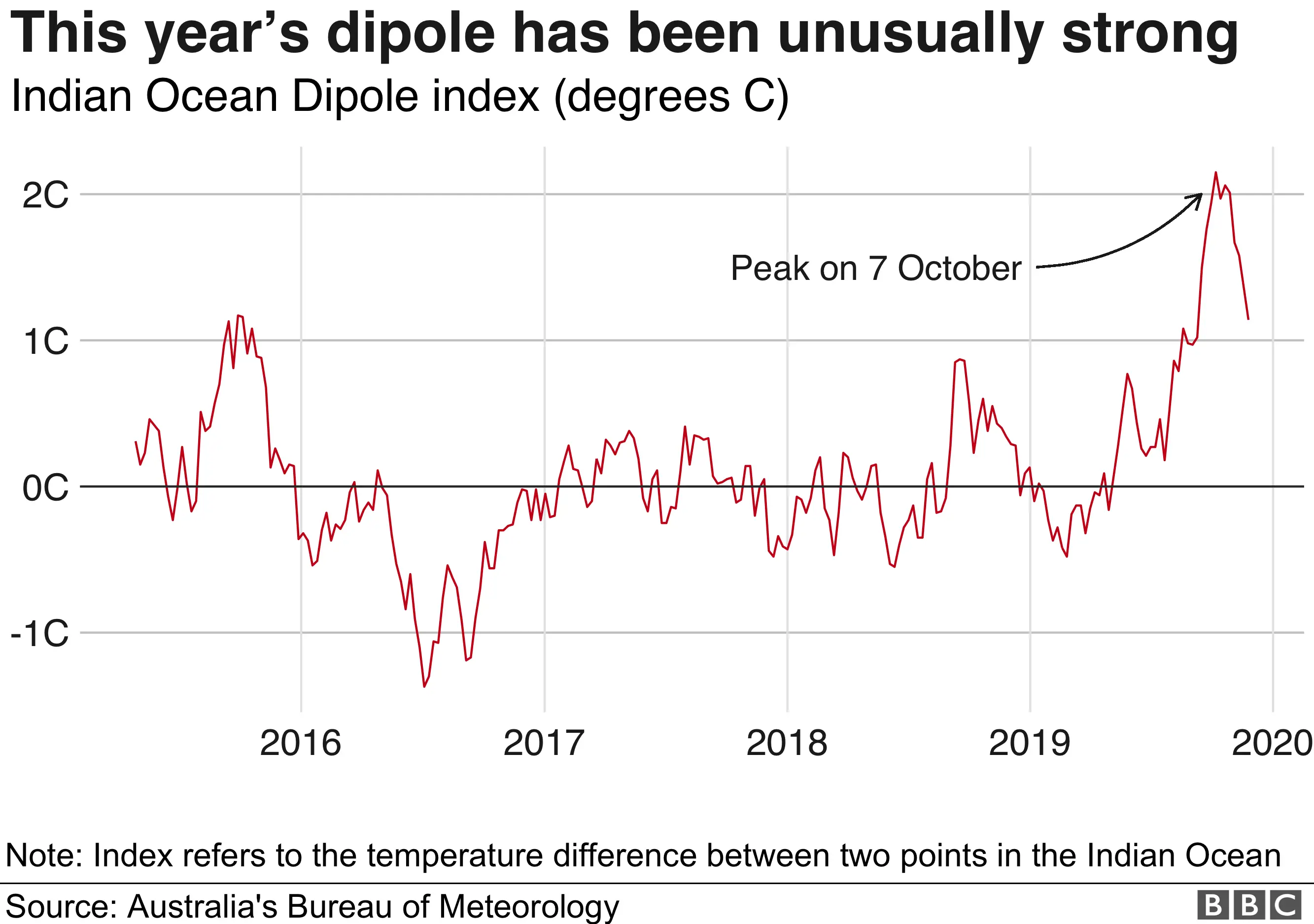
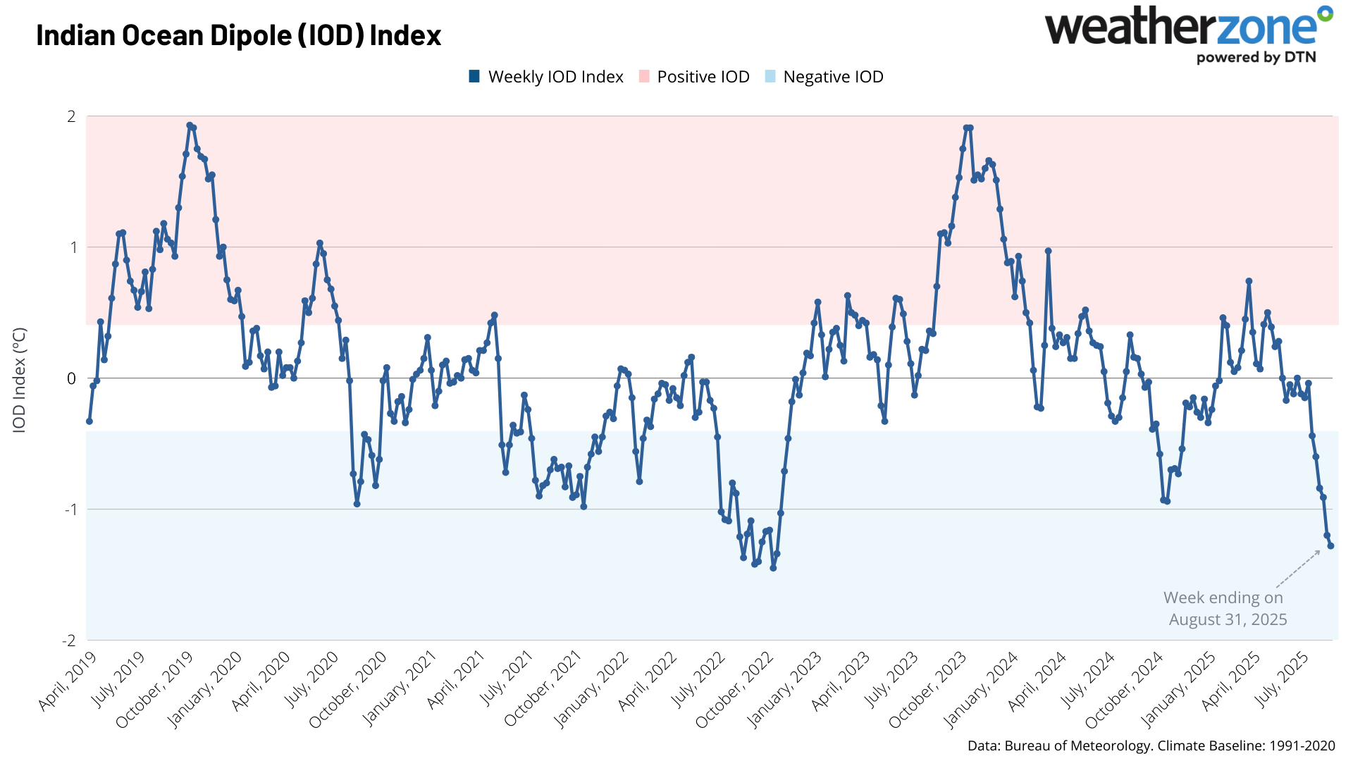
This is the strongest -IOD since the 22-23 and 16-17 La Ninas. My guess for the rest of this season is that the ACE will finish below the 161 level of last year. But we have to watch for a rebound in hurricane activity from mid to late September right into October which has been common since 2012.
-
Friday and Saturday look quite warm and humid.
-
Only if they are below/blue. Not sure he posts ones that show AN, ha.
-
I do think the steering pattern gets more “favorable” in the extended with ridging returning, but I’m not sure that’s in time for whatever pops from this current cherry in the tropical Atlantic.
-
-
Now that it’s really getting going (-IOD) it’s going to form a positive feedback loop with the developing Niña/SOI and really accelerate the EWBs, trade winds, which the models are projecting going further into September. A weak Niña state by the end of this month appears inevitable at this point. As to your last post on the Atlantic hurricane season:
-
Watch out for rattlesnakes!
-

2025 Atlantic Hurricane Season
NorthHillsWx replied to BarryStantonGBP's topic in Tropical Headquarters
EPS and GEFS both show notable upticks in activity beyond the 10th. As were in the peak of hurricane season that is not surprising. The good news is that at least through mid month, the eastern trough hangs on which continues to be a deterrent to any storm approaching from the east. I think the CAG seen on some GFS runs is overblown as it tends to do but with La Niña developing and a tendency for shear to decrease this time of year I’d expect to start looking to the carribean and southern gulf. SSTs continue to decrease off the east coast from NC northward and I fished Friday out of Morehead and can confirm how much it has cooled. Water was 76-77 until about 35 miles out and warmed to 82 in the stream. Contrast to when I fished last week of July in same location and the temp never fell below 83 from the inlet to the stream and the stream was 87. That’s a huge difference in energy available of anything threatens NC-northward from a month ago. To me, this feels like the lid is starting to come off a bit in the Atlantic and mid month looks to be quite active -
Strongest -IOD in 3 years.

-

September 2025 OBS-Discussion centered NYC subforum
SnoSki14 replied to wdrag's topic in New York City Metro
Next week look really pleasant. -
Currently 49.8/49.0 after a 47.3 low, another 40's morning! We could use a bit of rain, starting to get dry down this way. I can only imagine what it is like north of here where they only had a quarter to half inch of rain previous month!
-
Low of 55 this morning. Warmup starts today through Saturday, does not look like we make it even through the first week of September with no 90s (I’m still taken aback that we made it through August without a 90 degree reading) but the good news is yet another fall like airmass moves in to start next week. What a freaking pattern!
-
53F for low in Lanco. Extended looks very dry. .
-
Something must have changed with the 06Z runs or something. I'm going off-roading / camping in the George Washington National Forest starting on the 13th, and all of a sudden they're saying rain Friday, Saturday, Sunday, and Monday (12-15th!) I know that's still too far out to know, but for four days of rain, it has to be a larger system. I haven't had time to look at any models yet, but last night before I went to sleep, I think it had a chance of rain for Wednesday that week, but that was it. It really CAN'T be that weekend/early week because I'll still be on the trails and won't have the camp site set up yet. Saturday especially was just going to be a trail day - if it's raining Friday and Saturday that would be a bad idea with the mud and creek crossings.
-
Yep.
-
Guy uses CPC probability forecasts. Fucking joke. Enjoy 84-88 with dews Saturday in this frigid pattern.
-
Funny because I thought the modeling looked warmer in the extended overnight…more signs of persistent ridging and fewer cold intrusions.
-
Enso anomalies reluctant to make any major moves in latest readings. The -.4 is 3.4. 27AUG2025 20.5-0.3 24.3-0.6 26.3-0.4 28.5-0.2
-