All Activity
- Past hour
-
 90 /74 32nd day of 90+ here in southeast Passaic County, will it be our last this year?
 -

NEW DISTURBANCE: Central Tropical Atlantic (0/20)
GaWx replied to BarryStantonGBP's topic in Tropical Headquarters
From my perspective, I hope Erin takes her sweet time and thus reduces the chance this could hit the US. Being near the coast in a highly vulnerable location, I’ll take boring over interesting with this AOI. 12Z: CMC, Euro, Euro AIFS, and UKMET are all recurving between 65 and 70W. JMA isn’t out yet. ICON doesn’t go out far enough to know where it would go in relation to especially E NC and Cape COD but the 180 suggests it’s likely about to recurve, regardless. So, other than the still unknown JMA, the GFS is the only major operational global suggesting a big threat to the Conus with Icon being undetermined. -
. 33 nice watering garden
-
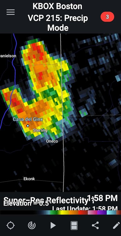
Private rain storm. Pouring
-
88.7/66 Rain would be nice
-
FROPA is through BTV… 70/57 (dew down almost 10F since 11am) It’s on our doorstep here now. 73/63
-
 Long duration heatwave 8 days 90/77/99
 -
Yesterday‘s rain shower helped ensure extra streamy today. 88/72
-
85/68 here. KFIT is 89/63
-

Hurricane Erin: 125 MPH - 946mb - WNW @ 13
Wannabehippie replied to BarryStantonGBP's topic in Tropical Headquarters
2:00 PM AST Sun Aug 17 Location: 21.3°N 68.0°W Moving: WNW at 13 mph Min pressure: 946 mb Max sustained: 125 mph -
 Down at the nautical mile for the first time in many years. Almost a perfect day just a bit cloudy
 -
yup!
-
Too many Vito’s in mine. My mom bucked the tradition 78+ years ago. The contentious fallout, sadly, lasted for decades. As always ….
-
Muggy

-
86/72 steambath
-
We had some muggy days last week but yeah now an Augdewest. But a great month so far and a steamer today.
-

Hurricane Erin: 125 MPH - 946mb - WNW @ 13
canderson replied to BarryStantonGBP's topic in Tropical Headquarters
The continuous S/W track makes me think Erin has eyes wanting to split the upright and run head first into Newfoundland. -
Ineedsnow still tracking?
-
Pretty similar. I'm barely at .75" since July 16. Truly remarkable how we struggle to rain given the heat and humidity we've experienced.
- Today
-
Due to Steim
-
Interesting storm...surprised to read this from Ars... "With a central pressure of 917 mb on Saturday, Erin ranks as the second-most intense Atlantic in the last 50 years prior to today's date, behind only Hurricane Allen in 1980."
-
Surfs up is the only thing that matters
-
Nice Eric
-
One of the reasons I like the SW Atlantic as a hot spot is the thermal environment. Erin is likely a blip, especially with it being mid August.
-
 I think we are underway with a significant dry pattern, much like last year. We'll see how long it persists but sure looks like the rest of this month is going to be dry. Expect upgrades (D1 or even D2) to the Drought Monitor in the coming weeks. Not expecting much today in terms of widespread coverage. If you get something consider yourself lucky.


.thumb.png.4150b06c63a21f61052e47a612bf1818.png)


