All Activity
- Past hour
-
I wonder if Mt. Holly reads this forum - they changed their advisory overnight to a Winter Storm Warning for North Central NJ
-

26th-27th event, coming at us like a wounded duck.
George001 replied to Go Kart Mozart's topic in New England
Yeah what a waste, sucks but at least we aren’t getting a 2 foot blizzard and wasting it. Probably only a few inches here, will look nice for a couple of days before the melt due to the cutter. 2 feet of snow then a cutter would be awful, there would be patches of dirty, filthy snow. Fortunately, there won’t be enough snow for that to happen. -

January 2026 Short/Medium Range Thread
Holston_River_Rambler replied to John1122's topic in Tennessee Valley
Anybody happen to see the HP the 0z GFS snuck out on top of Greenland? -
Rob , thanks ps I hope you enjoyed as I am shot myself we went to visit a neighbor for what was supposed to be a quick 10 minute visit and it turned out to be a 3 hour continuation of more wine and laughs ,,,enjoy the snow brother I hope Mother Nature gives us a belated Christmas gift,,,,,,,to those playing along at home the NWS upped totals overnight in my area ( New City Rockland ) from 4-8 to now 5- 9
-

December 2025 regional war/obs/disco thread
HoarfrostHubb replied to Torch Tiger's topic in New England
Welcome to the madness -

26th-27th event, coming at us like a wounded duck.
CoastalWx replied to Go Kart Mozart's topic in New England
Lift definitely shits out east of Kevin to Steve. Hopefully we keep ticking NE. -
14/3F, boiler humming, snow coming
-

26th-27th event, coming at us like a wounded duck.
Damage In Tolland replied to Go Kart Mozart's topic in New England
https://x.com/burgwx/status/2004529233054577051?s=46&t=dhcbvkjmRcyBVQtDxJ3lRg -
 lol, this obs is way too cold. I can't wait to see obs posts like this again: "Here in East Nantmeal we are already up to 73 degrees here at 1030am." "77F Trash cans went dancing" "Am actually sitting at 82 at post time." "81F With the clouds, low DP, breeze...not bad at all out there." "80F" "Had a couple raindrops then a pretty cool sunset. Maybe some showers late tonight / early morning? 74F/ breezy" "We reached 82.2 degrees here in East Nantmeal this PM"
 -
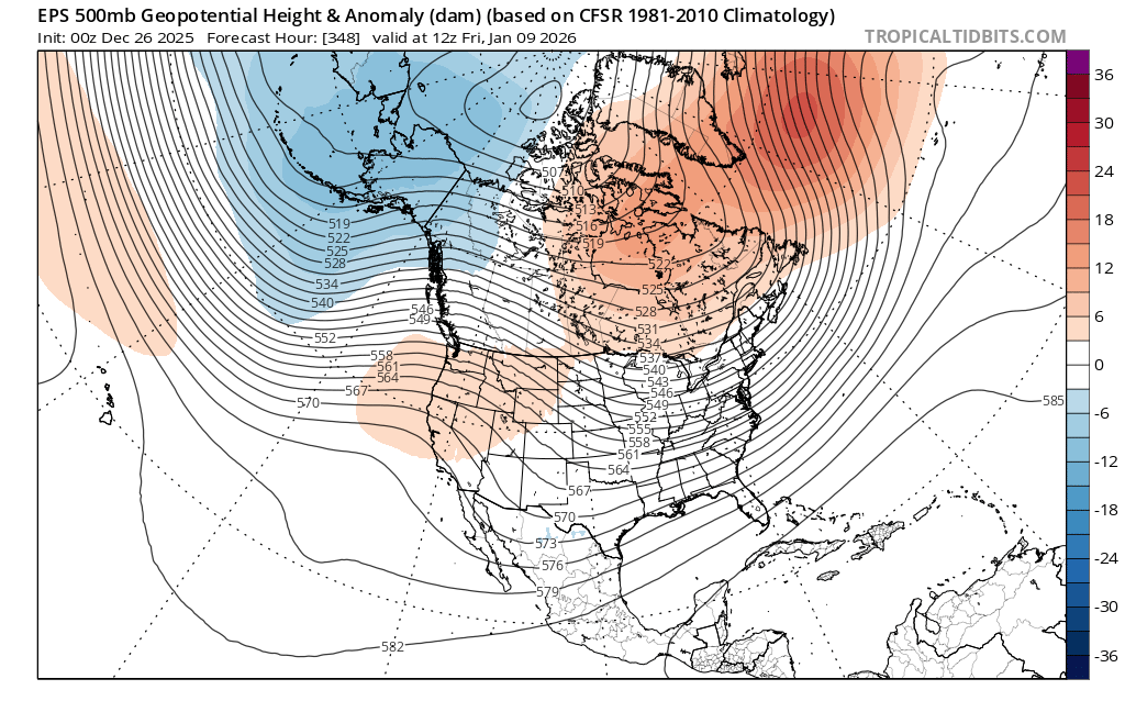
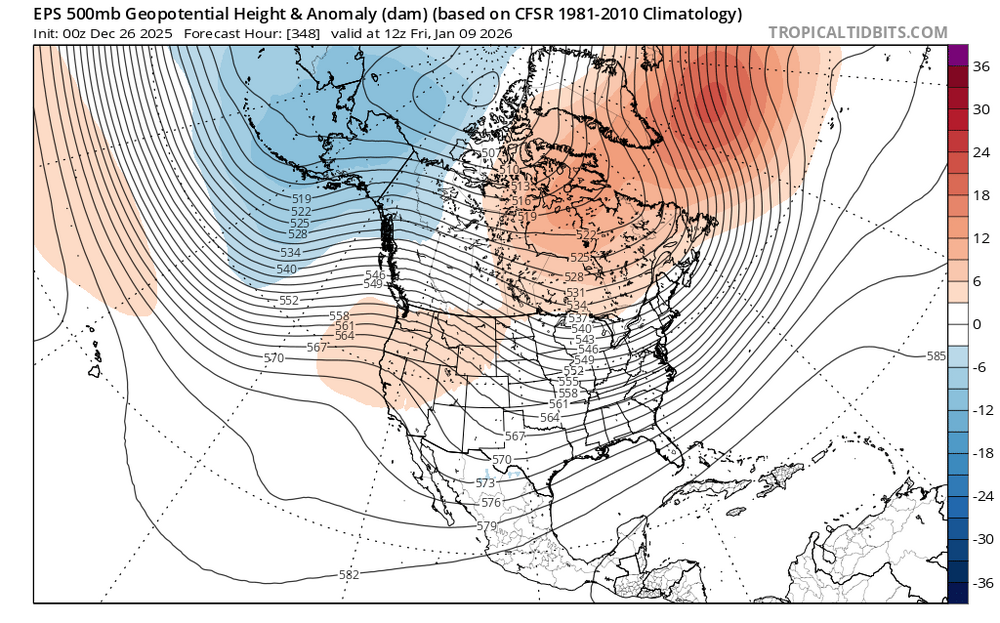
EPS for reference:
-

26th-27th event, coming at us like a wounded duck.
mattm4242 replied to Go Kart Mozart's topic in New England
-
All 3 global ensembles breakdown the Aleutian high. The 0z GEPS and 6z GEFS take it out just after 300. The 0z EPS wipes it out just after 200. All three end up with some version of blocking around Greenland, a ridge out West or the Eastern Pac, cold in Alaska, and BN temps and/or heights over the SE which is fed by an anomalously cold Yukon air mass. Sort of looks like the same pattern we had to start December? Right now, the potential cold pattern looks dry. I can't disagree with it. However, to quote a met in the ENSO thread...it is very unlikely modeling can see details this far out(referencing d+1-) regarding storms. Generally, I think our forum scores best when we have cold in place, or it is just lurking in the Plains. One would think the entire Canadian Rockies cold air mass kicks eastward at some point. It has during recent winters. There are hints of that in modeling - some sooner and some later. Lastly, LR ext modeling(weeklies) hints that the strongest cold shot will be near the end of January and into early February. I simply don't know at this range, but it is worth keeping an eye on.
-

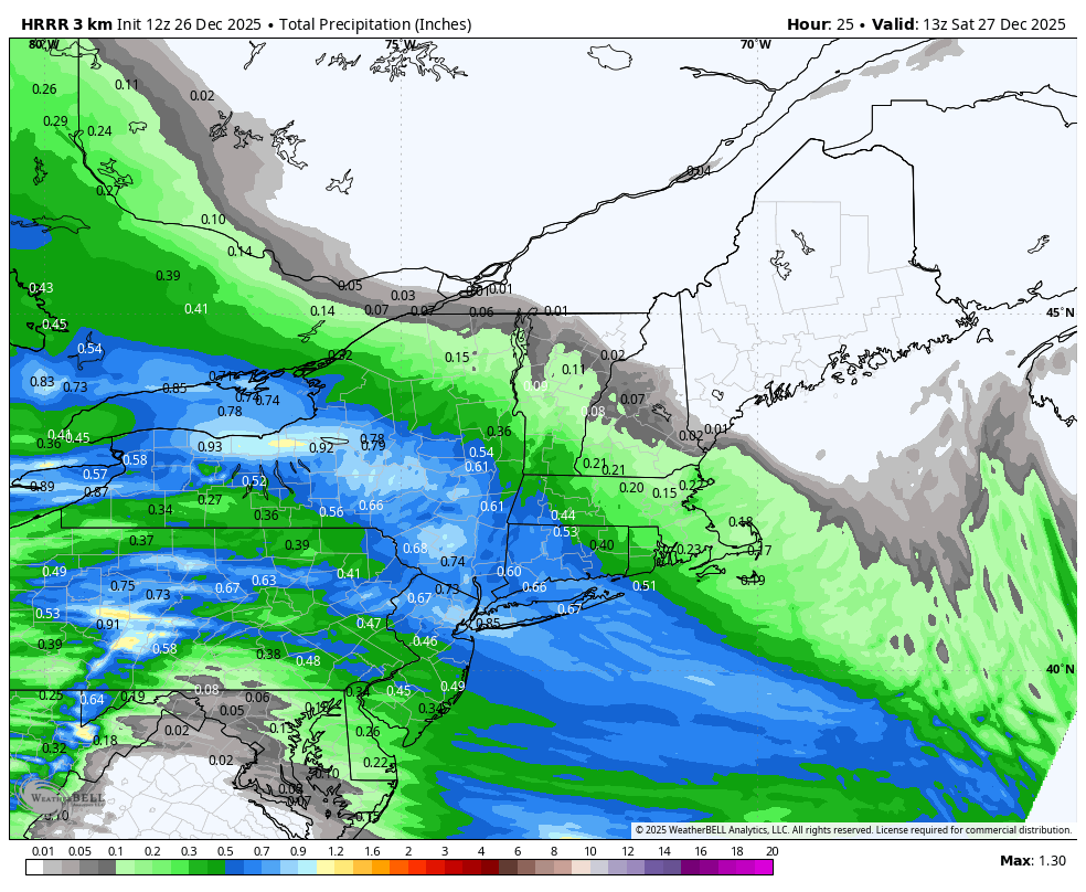
Boxing Night Snow/Sleet/Ice Dec 26-27 Storm Thread/Obs.
Ralph Wiggum replied to Mikeymac5306's topic in Philadelphia Region
Welcome aboard! -
Bullish!
-
GFS shifting south! NYC might get whiffed now…
-
I did not see the 6z EURO but hope it was even better than 0z
-

26th-27th event, coming at us like a wounded duck.
weatherwiz replied to Go Kart Mozart's topic in New England
Under the banding the snowfall rates would probably approach 2"/hr and maybe even upwards of 2.5". Feasibly, because of the crosshair signature (the -30 dissecting the snow growth zone) that should elicit great snowgrowth...the dendrites which accumulate quickly. I am a little worried though we may not get the perfect dendrites and snow growth will be a bit impacted by some dry air. The big question is what happens outside of the banding...that's where there could be more of a struggle and if we end up with multiple band signatures there will be some screw zones. In between these, perhaps even outside the banding, this is where you'll get more in the way of Arctic dust. Regardless, a widespread 4-7" is still in the cards but we need to be mindful there will be some screw zones. I don't think we'll see many totals eclipse 7-8" only because its really a 3 hour period of heavy accumulating snow and that's it. This is going to be fun to track in real time -

Central PA Winter 25/26 Discussion and Obs
canderson replied to MAG5035's topic in Upstate New York/Pennsylvania
Remember kids, don’t clear sleet until this event is over. ZR on sleet = manageable, zr on asphalt = bad timed -
Found it interesting that this was another event where a couple AI models kinda sniffed out the trend a run or two before the globals. That said, I think the Euro got its shine on this one.
-
This looks right to me, I would bump KNYC to 2.5 lol
-
I had a house full yesterday and was busy enjoying that, did look at much model stiff or help monitor the posters coming out of the woodwork, as is tradition before a snowstorm. Anyway, I would think we will at least see some flakes before 6pm.
-

Central PA Winter 25/26 Discussion and Obs
WmsptWx replied to MAG5035's topic in Upstate New York/Pennsylvania
That is Steven DiMartino from... Freehold, NJ. -

26th-27th event, coming at us like a wounded duck.
Sey-Mour Snow replied to Go Kart Mozart's topic in New England

-
26th-27th event, coming at us like a wounded duck.
Damage In Tolland replied to Go Kart Mozart's topic in New England
Should hold onto solid pack almost everyone with ice to Cold rain -
How did the 6z EURO look.