All Activity
- Past hour
-
Nudged just above 32 here as a line of thunderstorms is about to move through. Will be curious to see what kind of precip they have
-
I was a law enforcement officer in Durham for 30 years and retired in 2016. I was responsible for providing motorcycle and vehicle escorts to and from athletic events for Duke. I brought the bb team back from 3 National Championships in my career. Got to provide security for Coach K on many occasions. Just hope that Patrick G and Foster are able to return for the tournament. Go Duke
-
*URGENT* So I need some help. The older Ms. J is currently on a film project for her senior capstone aka student run project. She is a AD, assistant Director, on the current project. Anyways part of the AD’s job is safety. They are shooting in studio on AU’s campus Media Production Center. It is in the basement of the building so thinking that is the shelter for the building anyways. She has asked me to let her know the threat level. She texted me this morning. “if it is seeming enough that we either may lose power or have to shelter in place worse case scenario I have to hold a safety meeting tonight to tell everyone to get here safely tomorrow and another one tomorrow with protocols." If anyone can advise me. I have been following along with the two threads here on this set up but I am far from an expert on this. She is really big on doing her job correctly and wants to keep everyone safe so I told her I would help her with this as much as I can. Because her and I are huge weather buffs I am happy that she is on top of this as it may be something that is overlooked by others. I thank anyone in advance if I can give her a clearer understanding for her area of NW DC.
-
SPC Outlook maps for tomorrow as of the 1 AM update SPC AC 150607 Day 2 Convective Outlook NWS Storm Prediction Center Norman OK 0107 AM CDT Sun Mar 15 2026 Valid 161200Z - 171200Z ...THERE IS A MODERATE RISK OF SEVERE THUNDERSTORMS FROM NORTHERN SOUTH CAROLINA ACROSS NORTH CAROLINA AND INTO VIRGINIA AND MARYLAND... ...SUMMARY... Widespread severe storms are forecast on Monday for parts of the Mid-Atlantic States and Southeast. Tornadoes, potentially strong, and particularly damaging winds are most likely from South Carolina into Maryland during the afternoon. Significant severe storm potential overall will extend from eastern Georgia/Florida Panhandle into Pennsylvania. ...Synopsis... A large and deepening upper trough will pivot northeastward out of the OH/TN Valleys, across the Appalachians and into the Mid Atlantic on Monday, while a surface low deepens into southern Quebec. A sharp pre-frontal trough will extend southward across NY, PA, and into the Carolinas/GA by late afternoon, with a corridor of significant pressure falls timed with the diurnal heating maximum. A cold front will push rapidly east across GA and the FL Panhandle during the day with a bit slower progress across the Piedmont and into PA. Gusty south winds ahead of the cold front will maintain 60s F dewpoints across the entire region, and as far north as southern PA, just after warm front passage by late afternoon. Just above the surface, southerly 850 mb winds will increase from 50 to 75 kt, resulting in extreme shear profiles over a large area. Large-scale ascent and shear will increase coincident with the peak heating hours, resulting in a potentially widespread severe weather event during the afternoon. ...From Georgia and the Florida Panhandle... Early day storms may be ongoing from the southern Appalachians toward the FL Panhandle Monday morning, and the environment will already be favorable for supercells including tornado potential. Forecast soundings indicate substantial instability with mid to perhaps upper 60s F along with ample shear. These storms may also produce hail, as midlevel lapse rates approach 7 C/km. ...Carolinas into MD/PA and vicinity... Areas of showers may occur early in the day especially but should rapidly lift north, allowing areas of heating and gradual destabilization over the entire area. As the surface trough deepens, low-level wind will back and strengthen throughout the day. Supercells producing tornadoes appear most likely ahead of the cold front from SC into NC and southern VA. Models vary with degree of instability, but strong tornadoes do appear possible with effective SRH of at least 300-400 m2/s2. Fast storm motions over 50 kt suggest a long tracked tornado will be possible. Meanwhile, a robust line of storms will develop as the cold front pushes east, stretching from the Carolinas to southern NY. With a moist air mass and large-scale support, this line is expected to produce particularly damaging winds, along with QLCS tornadoes across the remainder of SC/NC, VA, MD, and much of southern PA. This will likely peak during the late afternoon hours. The activity may eventually interact with cool trajectories off the Atlantic during the evening. ..Jewell.. 03/15/2026
-

E PA/NJ/DE Spring 2026 Obs/Discussion
The Iceman replied to PhiEaglesfan712's topic in Philadelphia Region
See SEPA is totally screwed severe wise if the HRRR is right, this crap at 18z tomorrow basically ruins the entire threat, dc into central pa though look under the gun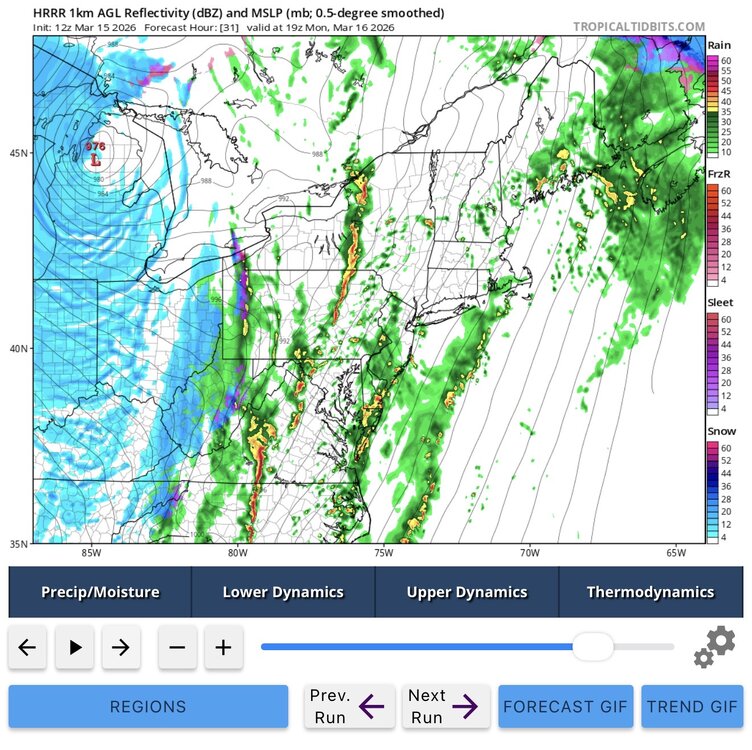
-
Not a flake here in town yet. They still think L superior will produce along the shore tho with 3+". Looks like 1-2" across N WI into EC MN so far. Here's the CoCoRahs site to get a better look at totals. They don't always get uploaded to the snow map right away. Just click the map (will open in a new tab), and make your parameter adjustments with the map options. https://www.cocorahs.org/ EDIT: Soon as I post this, --SN started.
-
Too confusing to me and I’m sure even more to general public.
-
Got to hand it to the GFS. Nailed the placement of the jackpot zone many days ago. Today is going to be a lot of fun.
-

Central PA Spring 2026 Discussion/Obs Thread
canderson replied to Voyager's topic in Upstate New York/Pennsylvania
Schools should have easy dismissals as well as companies tomorrow early afternoon. -
I remember that exact storm. It's one of several that displays why we need a separate NEXRAD radar and forecasting office here @ CLT Airport. Nobody should be that weather blind to bad weather development because of the weakness of the TCLT radar & distance from the other NEXRAD sites scans. It would be covering the area between the Foothills and Western Piedmont including Charlotte, Gastonia, Hickory, Statesville, Mooresville, Salisbury, Winston-Salem and High Point in NC. Those 4 Upstate counties (York, Lancaster, Chester, and Chesterfield) that are more economically tied and physically closer to Charlotte in SC like areas such as Rock Hill.
-
For those of you who haven't done any deep diving into the SPC videos for the new outlook styles - you could theoretically get an absurdly high PERCENTAGE now but with little or no CIG. That would be applied to times when 58-65mph winds for example might be a near lock and widespread - but the magnitude might not hit the 70-80mph+ range. The CIG categories are probably going to be the more important things to watch with this new era.
-
E PA/NJ/DE Spring 2026 Obs/Discussion
The Iceman replied to PhiEaglesfan712's topic in Philadelphia Region
Ehhh overnight runs shifted the threat more towards Lehigh valley and Lancaster for our area. Some of the meso’s now are bringing a lot of crapvection throughout the day and the QLCS breaks up and weakens as it approaches SE PA with zero instability. Mid Atlantic/DC area looks primed for a tornado outbreak though. It’s going to come down if the QLCS line can hold together or not for us. That change and slightly later timing though has made this less exciting than yesterday for se pa imo -

3/16/26 Severe Weather Event Thread (Day 2 MOD Risk)
Lucy Pull replied to Kmlwx's topic in Mid Atlantic
Agree with this premise. Do not think we would be seeing 60% wind probabilities with the old methodology. -
La Crosse AFD update talking about heavy thunder sleet this morning. Miss me with that! .
-
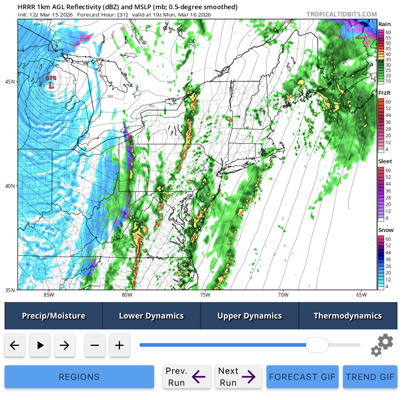
12z HRRR hot off the presses

-
Well one thing is - I wonder if those CSU-MLP maps have to be adjusted to account for the new SPC methodology.
-
Will certainly be a fun 24 hours. See how long it'll take gusts to start, hoping for some good GV storms maybe in a few hours, and I'd love to reel in some surprise death band tomorrow morning with winds but not holding onto that one ofc. Would love to see it happen though
-
So close, yet so far

-
Edit: actually maybe 7.3 officially, the 7.6 was at NWS office? Academic though. Hard to be disappointed about the relative “underperformance” with those numbers across the metro at our latitude. Especially knowing it was always gonna be a +/- 50 miles situation with the heaviest band.
-
Sister-in-law who lives in San Fransisco had her first kid a month ago and we are visiting them in early April. For their sake I’m hoping it’s 50s and rainy, but it’s the very end of the rainy season so a heat dome looks more likely. We have a place rented on the beach in Half Moon Bay, kids are gonna love the tide pools.
-
Once again, a tricky forecast to try nailing for LOT when models continue to shift areas of warning criteria snow in the NW areas. Although, selfishly, the most recent Euro would be insane for my area.

-
I’m interested to see how this plays out. I think this looks more realistic than the 60% wind. At least into Maryland maybe more impressive over central/eastern VA and NC. To me it doesn’t look all that impressive on models. I hope I’m right and we don’t get widespread wind damage. I don’t want to be without power for an unknown amount of time.
-
Will live or die by the overcast here today. A crap day or a decent day if there’s consistent breaks. It is very thin and sun beating through but still shrouded. In the east, we have a chance a mostly cloudy…we’ll see.
-
That jives with what I’m measuring 1-2mi north of the airport.
-
Ya I was kidding haha.