All Activity
- Past hour
-

Central PA Summer 2025
Mount Joy Snowman replied to Voyager's topic in Upstate New York/Pennsylvania
Low of 60. Back from the beach. Kids had an awesome time and the weather was perfect. No rain in the bucket here. -
No rain in the forecast for at least the next 10 days. What will it take to break the cycle?
-
Oh man....I dearly miss that warm Florida surf. It's been too many years since I've been there.
-
The lower ACE this season than last year wasn’t that much of a surprise. All our 161+ ACE years since 2010 have seen a steep decline the following years. This year the record mid-latitude SSTs and cooling tropics are the main features creating the more stable conditions like we have been seeing more frequently in recent years. So the direction lower this season on ACE is flowing the recent pattern. But magnitudes will be unique to each season. The amount of the decline can vary from year to year. The other similarity has been the lull during the typical peak of seasons which has been becoming more common. Plus the late September into October rebound off this quieter pattern to start September. While last season was more active, both years had a Cat 5 prior to the quieter periods. ACE step down pattern following 161+ seasons 2024….161….2025….39.3 so far 2020….180….2021…145…2022…94.4 2017….224….2018….132
-
Oh look! That's unusual! More rain and the lowlands are the bullseye. That's new lol. I hope this hot hand last into the winter.
-

2025-2026 ENSO
40/70 Benchmark replied to 40/70 Benchmark's topic in Weather Forecasting and Discussion
Mot of us have already been using this for a few seasons. -

September 2025 OBS-Discussion centered NYC subforum
bluewave replied to wdrag's topic in New York City Metro
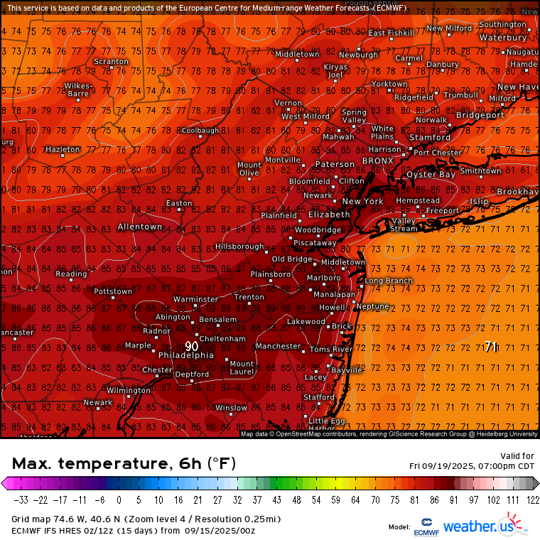
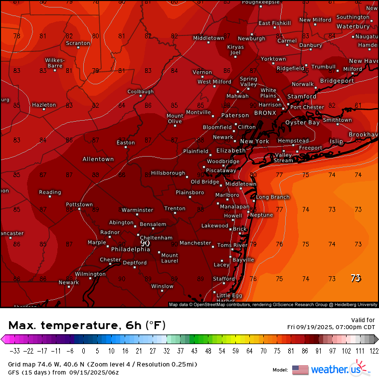
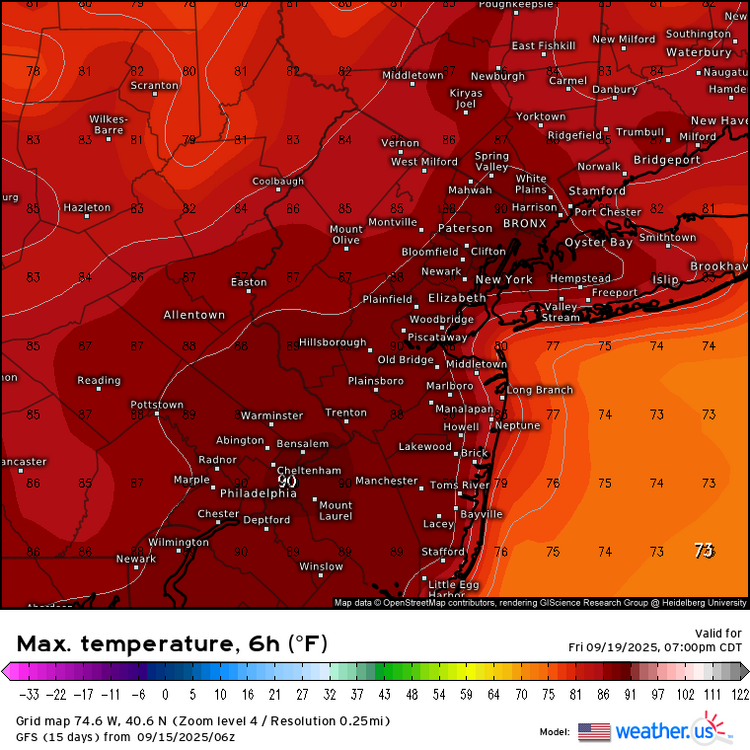
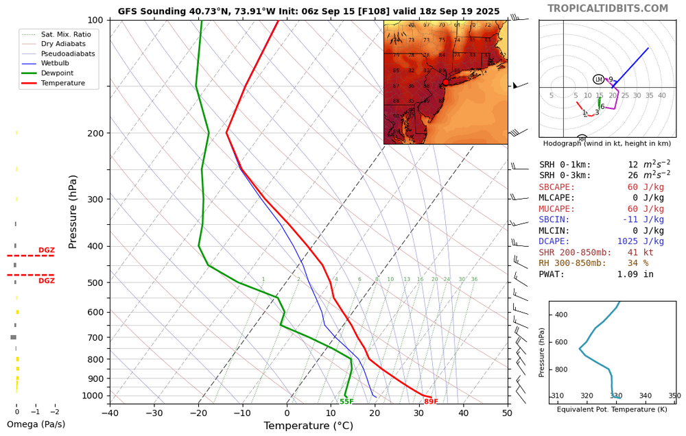
Friday looks like the warmest day of this week with Euro and GFS showing 85-90° potential on a dry W to NW downslope flow.
-
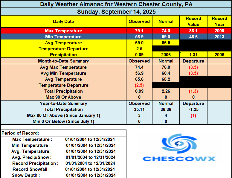
We have only seen 11 above normal temperature days in the last 44 days. Today should be one of those rare above normal temp days with highs well into the 70's to near 80 degrees. We turn cooler and possibly wetter by the middle of the week with our best chances of a little light rain coming on Tuesday night into Wednesday. We see a brief warm up by Friday before we turn quite a bit chillier once again by next weekend.
-
Brought the COC with me all the way to Florida. Record lows tonight. Surf is sweet water is so warm here.

-
(002).thumb.png.6e3d9d46bca5fe41aab7a74871dd8af8.png)
E PA/NJ/DE Autumn 2025 Obs/Discussion
ChescoWx replied to PhiEaglesfan712's topic in Philadelphia Region
We have only seen 11 above normal temperature days in the last 44 days. Today should be one of those rare above normal temp days with highs well into the 70's to near 80 degrees. We turn cooler and possibly wetter by the middle of the week with our best chances of a little light rain coming on Tuesday night into Wednesday. We see a brief warm up by Friday before we turn quite a bit chillier once again by next weekend.
-
We have had .08 inches in the last 30 days with none in sight for the next 2 weeks on the models. Everyone's lawn is toast,and oak trees dropping leaves. People on the coast should get some with that low though. High 80's with some low 90's thrown in for my area for the next few weeks.
-
Torch !!
-

Pittsburgh PA Fall 2025 Thread
TimB replied to TheClimateChanger's topic in Upstate New York/Pennsylvania
Low of 61 at PIT appears to break the streak of sub-60 lows at 21 days. Earliest in the season that we’ve recorded three full weeks of sub-60 lows. -

September 2025 OBS-Discussion centered NYC subforum
jm1220 replied to wdrag's topic in New York City Metro
Yawn. But Sept is usually a yawn month here unless a hurricane is coming up. Amazing how this season is dead as a doorknob though. - Today
-

September 2025 OBS-Discussion centered NYC subforum
SnowDemon replied to wdrag's topic in New York City Metro
And the 6z this morning says what 90s? lol. -
September 2025 OBS-Discussion centered NYC subforum
bluewave replied to wdrag's topic in New York City Metro
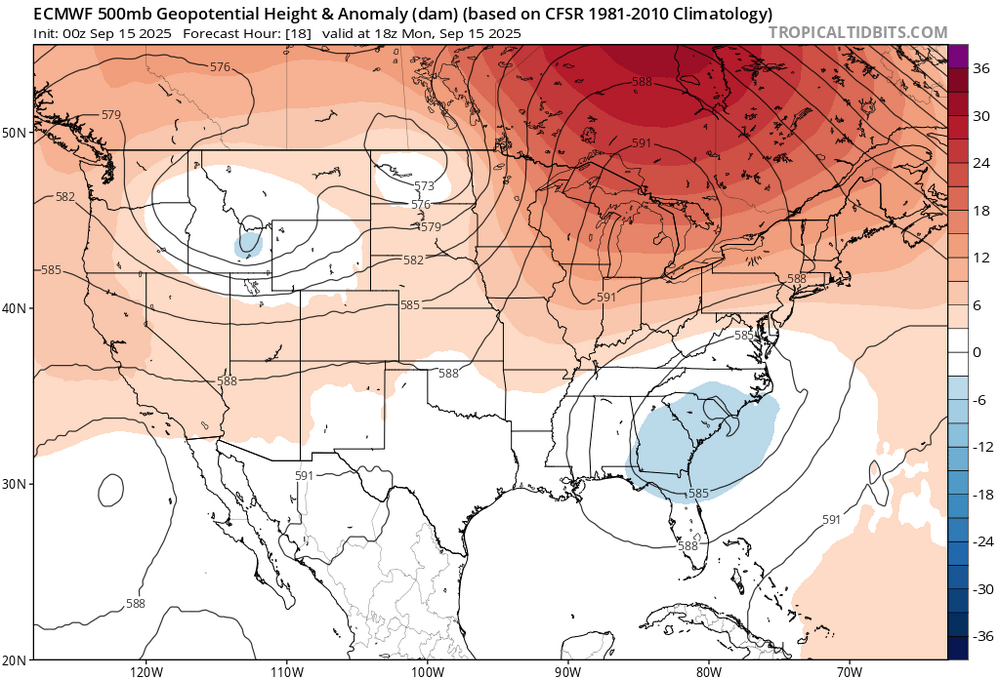
Record 500 mb ridge to our north will keep the heaviest rains to our south this week.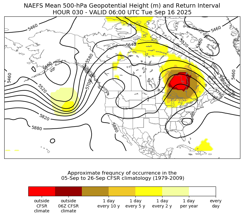
-
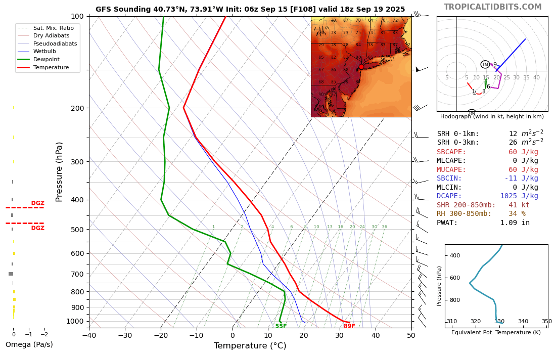
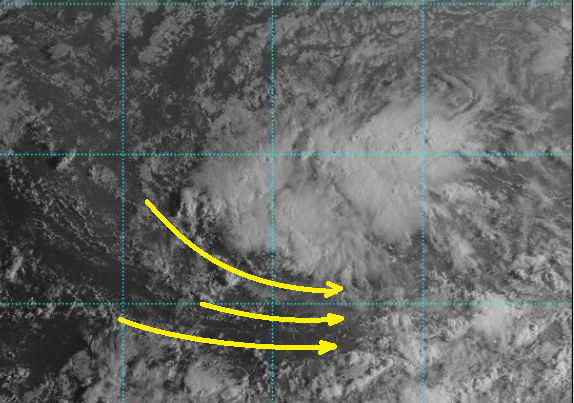
I'm not sure what the science is in this area of TC genesis ... or if there's any correlation at all, but this current high ranked invest out in the MDR has a very large initial mass field envelopment. I'm wondering if that presages a system that is also spatially larger than normal? It is evolving westerly return flow along the equatorial side, as evidence by cloud material/satellite, but these initial stages of that evolution extends to an unusually vast distance SW and S, some 500 km ...
-
Wow what a difference. 4 more days of 90s here on the other side of the state. Finally maybe some rain by Friday.
-
Soil moisture very low across the entire Northeast and Mid-Atlantic
-

September 2025 OBS-Discussion centered NYC subforum
Dark Star replied to wdrag's topic in New York City Metro
And on September first, PhiEaglesFan712 said fall had set in... -
September 2025 OBS-Discussion centered NYC subforum
Dark Star replied to wdrag's topic in New York City Metro
I'll take your word for it, though you ocean boaters probably aren't phased by 50 degrees and an onshore fetch... -

September 2025 OBS-Discussion centered NYC subforum
SACRUS replied to wdrag's topic in New York City Metro
63 / 61 p cloudy. Warm today and a bit more cloudy w/ upper 70s / low 80s. Onshore and more clouds building in Tue - Wed with the cut off ULL bringing showers / rain Wed / Thu AM. Clears out Thu PM / Friday warmest day in a while could see some upper 80s to 90 in the hottest spots. Dry weekend / a touch cooler/ Overall warmer Sep 9/22 and beyond. -

2025 Atlantic Hurricane Season
NorthHillsWx replied to BarryStantonGBP's topic in Tropical Headquarters
Having an AN season seems unattainable at this point in terms of ACE and even NS. NN might be a stretch. It would take another ACE monster like Erin to even approach normal levels. With only 1 hurricane thus far it seems unlikely we will reach our average hurricane count as well. The current cherry certainly could develop and pad those numbers a bit but even that systems development keeps getting delayed somewhat on modeling. Really at a loss of words for this September. I thought 91L was going to kick off a more active period. I can’t even imagine our opinion of the year if Erin did not become the ACE machine it was. -
Record breaking rainfall with the impressive -IOD pattern. La Niña in the modern climate The Bureau of Meteorology has just changed the way it calculates sea surface temperature anomalies for monitoring La Niña (and El Niño). Traditionally, sea surface temperatures inside the Niño 3.4 region were compared to the long-term average of the 30-year period from 1991 to 2020. The difference between the current temperature and the long-term average temperature gave us the anomaly used for monitoring La Niña. However, rising global ocean temperatures caused by climate change have made this method ineffective. Put simply, Earth’s oceans are warming so quickly that the average ocean temperature of the past 30 years is cooler than the current global ocean temperature. This makes Niño 3.4 index values artificially warm when calculated using the traditional method. Instead of comparing the current state of the ocean to a baseline from the past climate, scientists have developed a new method that also incorporates the current average temperature of the global tropical oceans. This new method, with is called the relative Niño index, removes the climate change signal from the equation and makes it more useful in our rapidly warming climate.
-
2025-2026 ENSO
40/70 Benchmark replied to 40/70 Benchmark's topic in Weather Forecasting and Discussion
Those 4 seasons are all normal to slightly above normal snowfall around here.