All Activity
- Past hour
-
If it has to rain on the Jersey Shore for the Lehigh Valley to get the big snows, I will forever accept it as perpetual payback for Boxing Day 2010.
-

Let’s talk winter!! Ohio and surrounding states!! 24'-25'
pondo1000 replied to buckeye's topic in Lakes/Ohio Valley
Snowing in Marysville according to a friend. -

“Cory’s in LA! Let’s MECS!” Jan. 24-26 Disco
Sey-Mour Snow replied to TheSnowman's topic in New England
Yikes, bad typo lol I'm going back to laying down, this cold is killing me. -
URGENT - WINTER WEATHER MESSAGE National Weather Service Baltimore MD/Washington DC 832 PM EST Sat Jan 24 2026 ...MAJOR WINTER STORM WILL IMPACT THE REGION THIS EVENING THROUGH SUNDAY EVENING... .A large area of precipitation will overrun Arctic air in place over the Mid-Atlantic. This will lead to widespread significant snow beginning this evening, with the potential for ice Sunday especially south of Highway 50 and near and east of Interstate 95. In addition to the high threat for significant snow and ice, very cold temperatures are expected tonight through the middle of next week with sub-zero wind chills likely at times. MDZ003>005-502-VAZ028-030-031-040-501-505-WVZ050>053-504-250945- /O.CON.KLWX.WS.W.0001.260125T0400Z-260126T0900Z/ Washington-Frederick MD-Carroll-Central and Eastern Allegany- Frederick VA-Warren-Clarke-Rappahannock-Northern Fauquier-Western Loudoun-Hampshire-Morgan-Berkeley-Jefferson-Eastern Mineral- 832 PM EST Sat Jan 24 2026 ...WINTER STORM WARNING REMAINS IN EFFECT UNTIL 4 AM EST MONDAY... * WHAT...Heavy mixed precipitation expected. Total snow and sleet accumulations between 10 and 14 inches, with up to 18 inches possible near the Mason-Dixon line. Ice accumulations up to a tenth of an inch, mainly across the northern Shenandoah Valley. * WHERE...Portions of north central and western Maryland, northern and northwest Virginia, and eastern and panhandle West Virginia. * WHEN...Until 4 AM EST Monday. * IMPACTS...Travel could be very difficult to impossible. * ADDITIONAL DETAILS...Snow will likely overspread the area tonight, becoming heavy at times with rates of one to two inches per hour possible at times. A mix with sleet or freezing rain is expected Sunday. Visibility of one-quarter mile or less is possible at times. A prolonged period of very cold wind chills continues this evening and lasting through the middle of next week. NWS keeping forecast as us for NW.
-

Pittsburgh/Western PA WINTER ‘25/‘26
Ahoff replied to Burghblizz's topic in Upstate New York/Pennsylvania
High end is as high as it's ever been. -

Richmond Metro/Hampton Roads Area Discussion
RVASnowLover replied to RIC Airport's topic in Mid Atlantic
Light snow in Scott’s Addition, Richmond. Light dusting on cars and road -

“Cory’s in LA! Let’s MECS!” Jan. 24-26 Disco
Damage In Tolland replied to TheSnowman's topic in New England
Beer? -

Southern Crippler - Get well soon Jimbo Storm Obs
landof2rivers replied to BooneWX's topic in Southeastern States
It’s been sleeting here for 45 ish minutes. Roads have slight coverage. Was hoping for snow but I’ll take sleet vs freezing rain. That may still occur but for now it’s a W. -

Extreme Cold, Snow & Sleet: SECS 1/24 - 1/26
nycsnow replied to TriPol's topic in New York City Metro
The NAM cooled at 18z and has 0 support atm -

“Cory’s in LA! Let’s MECS!” Jan. 24-26 Disco
40/70 Benchmark replied to TheSnowman's topic in New England
Well, they are the same model.... -

Southern Crippler - Get well soon Jimbo Storm Obs
BooneWX replied to BooneWX's topic in Southeastern States
I can confirm in the foothills that it’s not drizzle. Actual drops unfortunately. -

Pittsburgh/Western PA WINTER ‘25/‘26
ChalkHillSnowNut replied to Burghblizz's topic in Upstate New York/Pennsylvania
My start time per that graphic was 7-9….nothing yet-wonder if that’s good or bad it’s delayed a little…. -

January 25-26 Winter Storm Potential
Ralph Wiggum replied to Ralph Wiggum's topic in Philadelphia Region
Ahhh, 2017. The one 4-pack im hanging onto is 2022. Had a Hazelnut Stout from Founders I aged for 3 years....smooth! -
Oh okay. You referenced CAD, so I was more talking about traditional surface CAD. Here it kind of holds on a bit longer due to latitude, but they will changeover out here. Sorry if I misunderstood!
-

Southern Crippler - Get well soon Jimbo Storm Obs
Regan replied to BooneWX's topic in Southeastern States
Sleet in Raleigh again. -

Southern Crippler - Get well soon Jimbo Storm Obs
olafminesaw replied to BooneWX's topic in Southeastern States
How is that even possible? Must be some kind of freezing drizzle showing up at ground at ground level -
Pittsburgh/Western PA WINTER ‘25/‘26
Ahoff replied to Burghblizz's topic in Upstate New York/Pennsylvania
Can't believe the trends have been positive up to the start. We might really be getting the big one again finally! This is cool. -

Southern Crippler - Get well soon Jimbo Storm Obs
JoshM replied to BooneWX's topic in Southeastern States
26.6/5.5 -

2025-2026 Fall/Winter Mountain Thread
LakeNormanStormin replied to Buckethead's topic in Southeastern States
Any chance you can post a map of those? Much thanks -

January 25-26 Winter Storm Potential
LVblizzard replied to Ralph Wiggum's topic in Philadelphia Region
I will not fall for the HRRR again I will not fall for the HRRR again I will not fall for the HRRR again I will not fall for the HRRR again I will not fall for the HRRR again I will not fall for the HRRR again -
 Yeah we just need qpf up here. Give us that and I will roll the dice on ratios
 -
January 25-26 Winter Storm Potential
Ralph Wiggum replied to Ralph Wiggum's topic in Philadelphia Region
You forgot to add, this is the first run that gets plain rain into SE PA The damage is done, but still.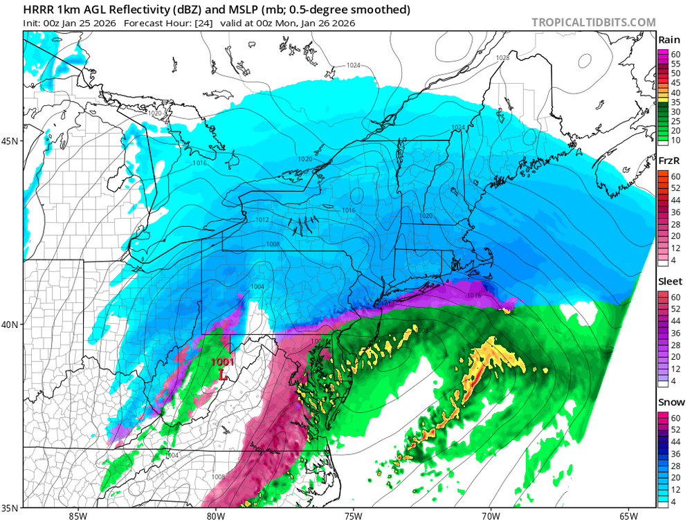
-

Southern Crippler - Get well soon Jimbo Storm Obs
AGardiner87 replied to BooneWX's topic in Southeastern States
Townhouses next to Bruster’s on 160. We should meet up at Model A for a beer and weather chat! -
Isn't the cold air up at 700-800mb, though? That's not really "near" the surface. Wouldn't it be more of a gradient just because the warm nose just takes a little bit longer to reach those NW areas not because of elevation, but because they're just farther NW?
-
“Cory’s in LA! Let’s MECS!” Jan. 24-26 Disco
Sey-Mour Snow replied to TheSnowman's topic in New England
00z HRRR looks exactly like RGEM cold and snow output


