All Activity
- Past hour
-

September 2025 OBS-Discussion centered NYC subforum
LibertyBell replied to wdrag's topic in New York City Metro
it must have sparkled like pixie dust lol -
September 2025 OBS-Discussion centered NYC subforum
LibertyBell replied to wdrag's topic in New York City Metro
103 in late September?? omg if that happened now people would go CRAZY Is that the highest temperature ever recorded in our area after the autumnal equinox, Tony? -
models showing 2 to 3 with isolated amounts up to 4
-

September 2025 OBS-Discussion centered NYC subforum
ForestHillWx replied to wdrag's topic in New York City Metro
Merciful rain shower out this way; LFG!! -
100%. Agree... As we have said a million times, there is a well established large scale climo pattern for a New England hit! Once again this not it! Show me a past storm that made landfall with our current pattern several days out? Every winter folks love to chat about how a pattern is favorable or not favorable for a Kocin storm, but when it comes to hurricanes, so many folks just follow modeled surface tracks without ever mentioning the total lack of upper support?
-
Probably non-tropical, but still powerful as it approaches the Iberian peninsula.
-

September 2025 OBS-Discussion centered NYC subforum
Sundog replied to wdrag's topic in New York City Metro
The was the first and last time I was able to "shovel" 8 inches of snow with a broom, and I mean really effortlessly. The ratios were outrageous. -
-

September 2025 OBS-Discussion centered NYC subforum
SACRUS replied to wdrag's topic in New York City Metro
it was 103 in 1895 in New Jersey. New Brunswick record for gthe day was a high of 103. Newark Sep 1895 September 20 90 62 0.00 0.0 September 21 98 69 0.00 0.0 September 22 96 70 0.00 0.0 September 23 97 70 0.00 0.0 NYC Sep 1895 September 20 93 68 0.00 0.0 September 21 95 77 0.00 0.0 September 22 95 75 0.00 0.0 September 23 97 76 0.00 0.0 September 24 78 63 0.00 0.0 September 25 77 60 0.00 0.0 September 26 90 73 0.21 0.0 -
Feels like Deep South Georgia
-
I have been keeping up on the tropics somewhat, here and elsewhere, due to my affinity for those that track a couple hundred miles offshore New England, and produce some of our cleanest, nicest, juiciest waves. I go to Point Judith, or elsewhere (30 years, year round). Point being--there is a cane to track right now (the second one)!
-
Just a little steamy out there this evening. The ol Florida Everglades have decided to pay us a visit apparently, quick downpours and manbuns included.
-

September 2025 OBS-Discussion centered NYC subforum
donsutherland1 replied to wdrag's topic in New York City Metro
I recall that event. There was sea smoke rising from the Long Island Sound even as the snow was falling. I doubled the size of an old photo from that storm and highlighted some of the sea smoke.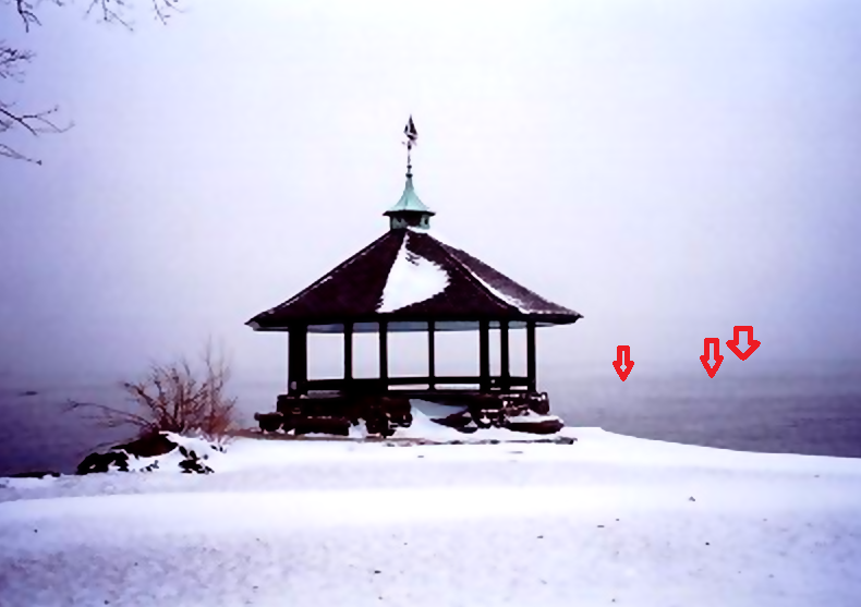
-
September 2025 OBS-Discussion centered NYC subforum
Sundog replied to wdrag's topic in New York City Metro
A more recent event would be January 15th 2004 when it started to snow at 14 degrees in Central Park the evening before and finished up the following morning with about 6 to 9 inches of ultra fluff and a temp of 8 degrees. That day's high was 18 with a low of 2. -
0.00” here thus far
-
I'd say 200-300 years. But who knows. Mother nature will probably throw a curve ball and we'll have ice age lol
-
you'll probably be dead by then
-

E PA/NJ/DE Autumn 2025 Obs/Discussion
RedSky replied to PhiEaglesfan712's topic in Philadelphia Region
Mine was worth a thousand it dumped .30" -
To my nonexpert eye, two things: one is that the path of the low is tracking further NW; secondly, its trailing front looks like it will be more progressive so that any lingering moisture or waves will stay well east/south of DMV late week/weekend.
-
I just took you off ignore like a month ago. Don’t blow it.
-

Central PA Summer 2025
Mount Joy Snowman replied to Voyager's topic in Upstate New York/Pennsylvania
Our area just won’t quit this year. -

E PA/NJ/DE Autumn 2025 Obs/Discussion
Albedoman replied to PhiEaglesfan712's topic in Philadelphia Region
Million dollar t storms right now - Today
-
Flash flood warnings going up .
-
I wonder what the conditions would have to be where one can reliability say that 2003/2010/2016 will never happen again even if you live in Boston and if you want that level of snow again you’ll have to move north AND up in elevation.
-
September 2025 OBS-Discussion centered NYC subforum
donsutherland1 replied to wdrag's topic in New York City Metro
For Central Park: February 13, 1899: 16.0" snow (High: 11°; Low: 6°) For Newark: December 26, 1872: 16.0" snow (High: 11°; Low: 5°) For Central Park, 18.0" fell on December 26, 1872 with a high of 12° and low of 6°. Data for Measurable Snowfall: Coldest High for Measurable Snowfall: New York City: 8°, February 8, 1895 and December 29, 1917 Newark: 4°, December 29, 1917 Coldest Low for Measurable Snowfall: New York city: -6°, December 29, 1917 Newark: -6°, February 11, 1899 and January 14, 1912


.thumb.jpg.6a4895b2a43f87359e4e7d04a6fa0d14.jpg)


