All Activity
- Past hour
-

Augdewst 2026: Summer's Last Stand
dendrite replied to Prismshine Productions's topic in New England
Because SC. j/k I lived in SW FL for a year. It was nice, but I missed it up here. This is home. And a lot of the fruit I like to grow doesn’t do well in the deep south. I love the seasons, but as I get older winter just feels longer and more grueling. It’s different up here than a lot of SNE too. The CAD foils a lot of the warmups and often keeps snowpack in place for months without much of a break. That may sound like a winter weather humble brag, but it isn’t. When I need a weather mental health break and it’s 33F and fog here for 48hrs while it’s 55-60° from BOS to BDL I want to break things and ban people near the Pike. -
 What a mess
 -

Augdewst 2026: Summer's Last Stand
CoastalWx replied to Prismshine Productions's topic in New England
Maybe some decent rain chances this week? Scattered stuff later today and this evening. -

Central PA Summer 2026 Discussion/Obs Thread
mahantango#1 replied to Voyager's topic in Upstate New York/Pennsylvania
Wow 3 days in a row of possible severe weather. -

Record Number of Extreme 10”+ Rainfall Months Since 2003
bluewave replied to bluewave's topic in New York City Metro
We can add August 2026 to the list also. Monthly Data for August 2026 for Upton NY NWS CWA Click column heading to sort ascending, click again to sort descending. NJ CLARK TWP 1.3 ENE CoCoRaHS 12.43 NJ HARRISON COOP 11.74 NJ CRANFORD TWP 1.1 ESE CoCoRaHS 10.93 NY FRANKLIN SQUARE 1.1 N CoCoRaHS 10.90 NJ KEARNY 1.7 NNW CoCoRaHS 10.84 NJ CLARK TWP 0.7 SSW CoCoRaHS 10.83 NJ NEWARK LIBERTY INTL AP WBAN 10.16 -
.thumb.jpg.6a4895b2a43f87359e4e7d04a6fa0d14.jpg)
Central PA Summer 2026 Discussion/Obs Thread
Yardstickgozinya replied to Voyager's topic in Upstate New York/Pennsylvania
And Thursday.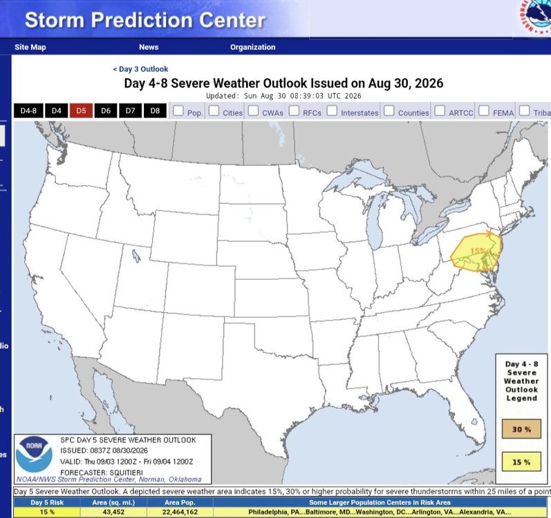
-
Central PA Summer 2026 Discussion/Obs Thread
Yardstickgozinya replied to Voyager's topic in Upstate New York/Pennsylvania
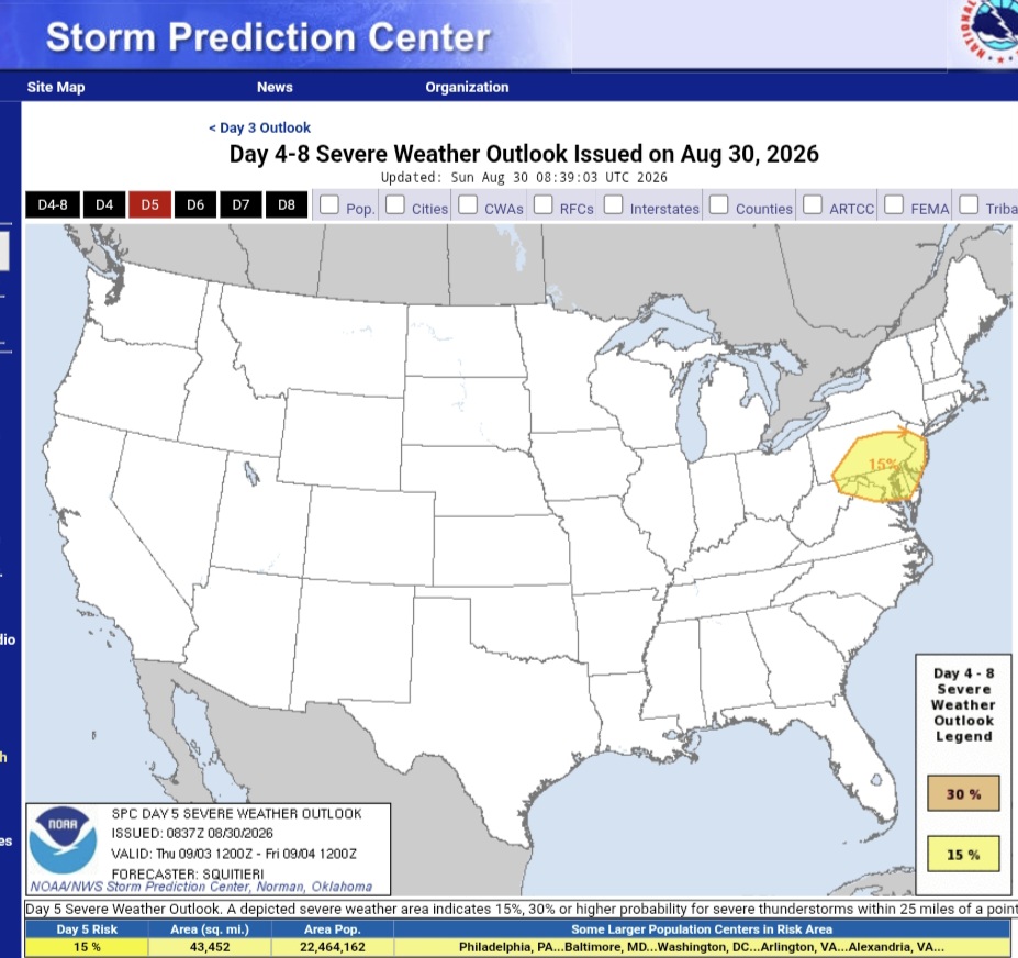
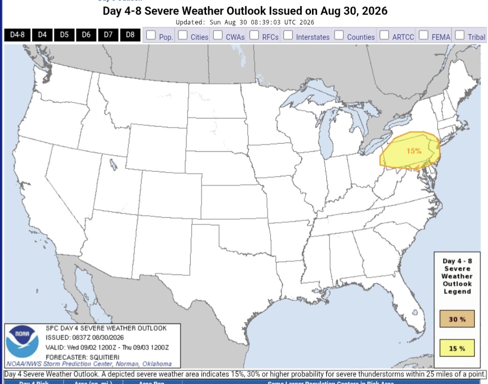
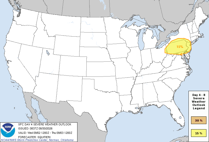
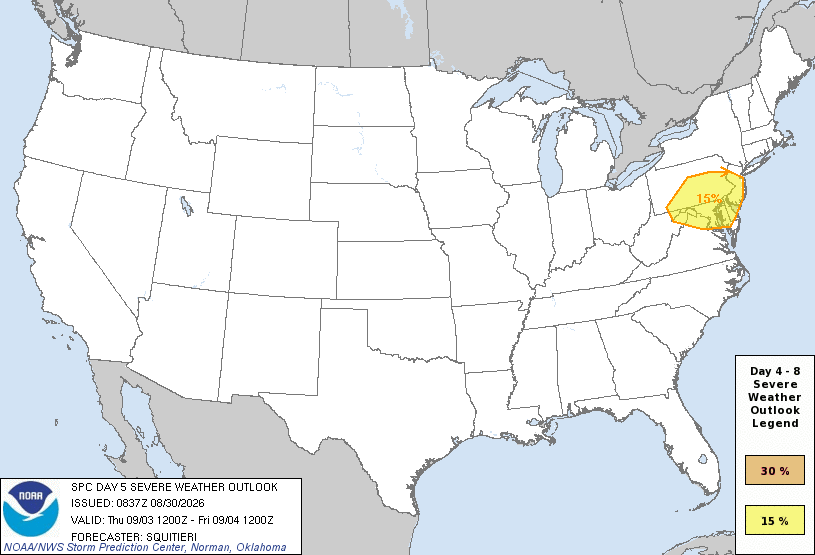
Wednesday Convective Outlook NWS Storm Prediction Center Norman OK 0337 AM CDT Sun Aug 30 2026 Valid 021200Z - 071200Z ...DISCUSSION... An upper ridge will remain centered over the TN Valley/central Appalachians through the end of the week before retrograding westward toward the Plains by next weekend. Multiple mid-level impulses and shortwave troughs will traverse the upper ridge this week before upper troughing dominates the Interior West toward the end of the extended forecast period. The best chances for severe thunderstorms will be with the aforementioned impulses traversing the ridge over the Great Lakes to the East Coast, particularly during the middle of the week. ...Days 4-6 (Wednesday-Friday) - Northeast to Mid-Atlantic... Severe probabilities have been maintained for portions of the lower Hudson Valley into the Mid-Atlantic Day 4/Wednesday, as guidance consensus continues to show a well-timed shortwave trough overspreading this region. Medium-range guidance continues to show a convective precipitation signal accompanying this impulse along with appreciable buoyancy and vertical wind shear. It should be noted that convective overturning from Day 3 (Tuesday) storms may stabilize part of this area, with the specific location of storms becoming dependent on residual baroclinic boundaries. As such, the exact placement of Wednesday's severe probabilities may need to be adjusted accordingly. Likewise, for Day 5/Thursday, another mid-level impulse will traverse the northeast extent of the upper ridge and overspread the Mid-Atlantic. Given adequate buoyancy and shear likely remaining in place, 15 percent severe probabilities have been introduced. As with the previous day, these probabilities may need some adjustment in future outlooks based on where airmass modification along baroclinic zones occurs. Medium-range guidance continues to show a pronounced mid-level impulse, accompanied by adequate deep-layer shear and buoyancy, impinging on the Mid-Atlantic on Day 6/Friday, which would support at least an isolated severe threat. ML/AI guidance also suggests that the Friday severe threat would encompass the ending stages of a potential multi-day severe episode. Given the multiple preceding days of storms and constant shift in favorable corridors modulated by baroclinic zones, confidence is very low for realistically pinpointing a focused severe area. However, it appears the Delmarva may be the most likely area for seeing organized storm activity. ..Squitieri.. 08/30/2026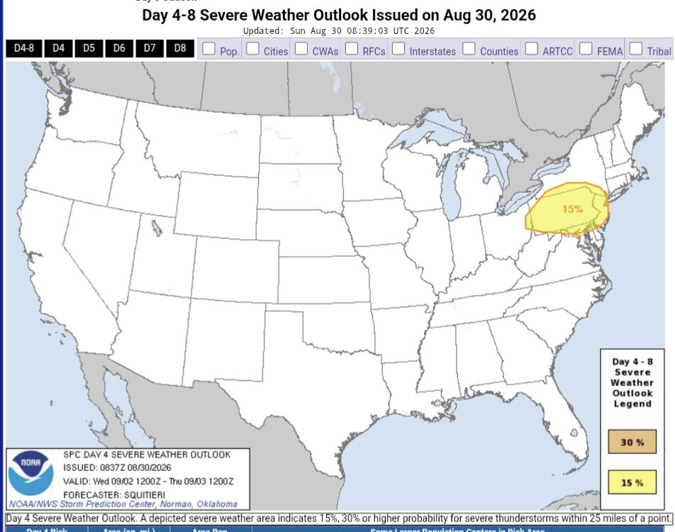
-
Central PA Summer 2026 Discussion/Obs Thread
Yardstickgozinya replied to Voyager's topic in Upstate New York/Pennsylvania
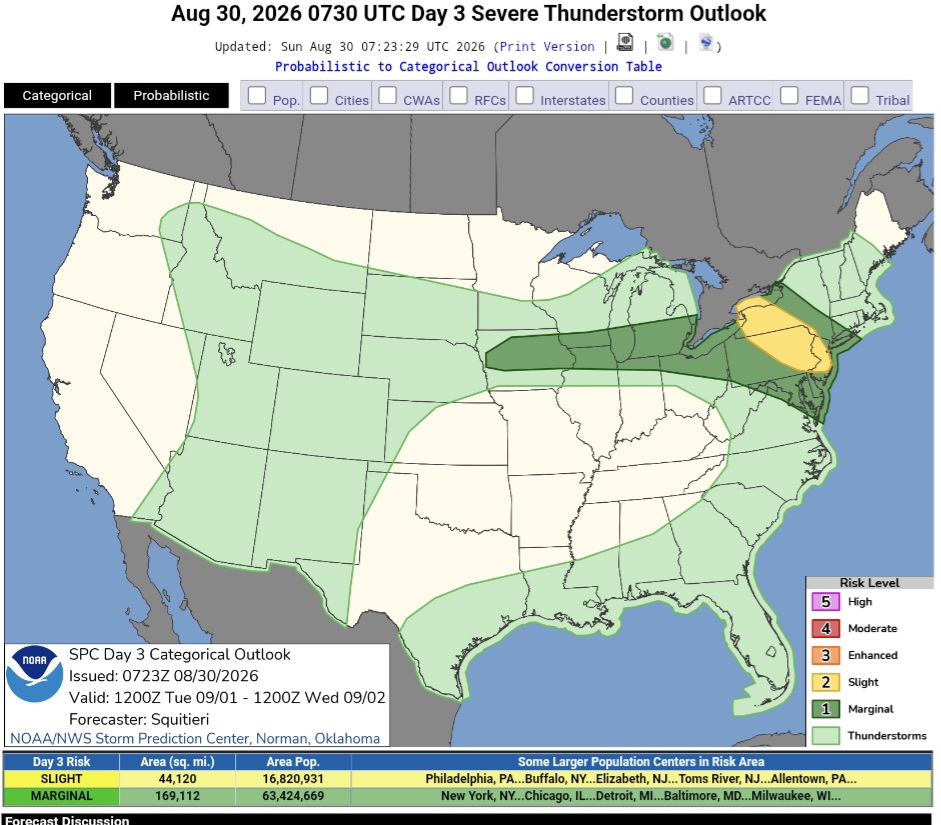
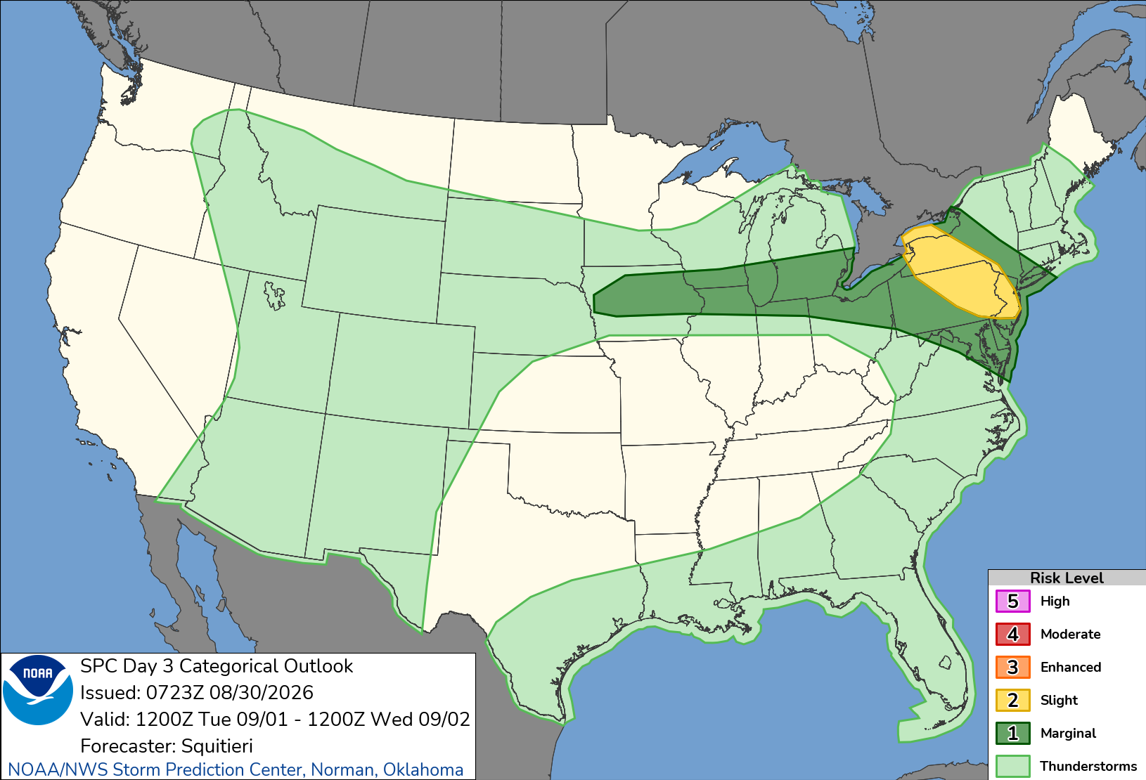
Tuesday Day 3 Convective Outlook NWS Storm Prediction Center Norman OK 0223 AM CDT Sun Aug 30 2026 Valid 011200Z - 021200Z ...THERE IS A SLIGHT RISK OF SEVERE THUNDERSTORMS ACROSS PARTS OF THE LOWER HUDSON VALLEY... ...SUMMARY... At least a few storms capable of producing severe wind/hail and perhaps a tornado are all possible across portions of the Lower Hudson Valley on Tuesday. ...Synopsis... An upper ridge will become centered over the TN Valley on Tuesday as a mid-level trough becomes situated over the Interior West, and multiple embedded impulses overspread the Great Lakes and Northeast regions. Rich low-level moisture will become established along the periphery of the upper ridge, overspread by cooler temperatures and stronger flow aloft with the passage of the aforementioned impulses. Strong to severe thunderstorms may result, especially over portions of the Northeast. ...Portions of the Northeast... Deterministic guidance members are beginning to demonstrate a consensus in depicting an embedded mid-level impulse ejecting from the Great Lakes and impinging on the lower Hudson Valley while pivoting around the upper ridge. While mid-level lapse rates accompanying this perturbation may not be particularly steep, (e.g. between 6.5-7 C/km), rich low-level moisture (e.g. low to mid 70s F dewpoints) will be present. Furthermore, forecast soundings depict appreciably curved and elongated hodographs, suggesting some storms may obtain supercell structures. A severe wind and hail threat may accompany the stronger storms and a tornado cannot be ruled out. There is the potential for earlier day clouds and precipitation, which may yield a differential heating zone. Should this occur, severe potential may be confined to this baroclinic boundary. Since the specifics on the placement of such a boundary are too difficult to pinpoint this far in advance, a Category 2/Slight Risk has been introduced with the understanding that these probabilities may be modified in future outlooks.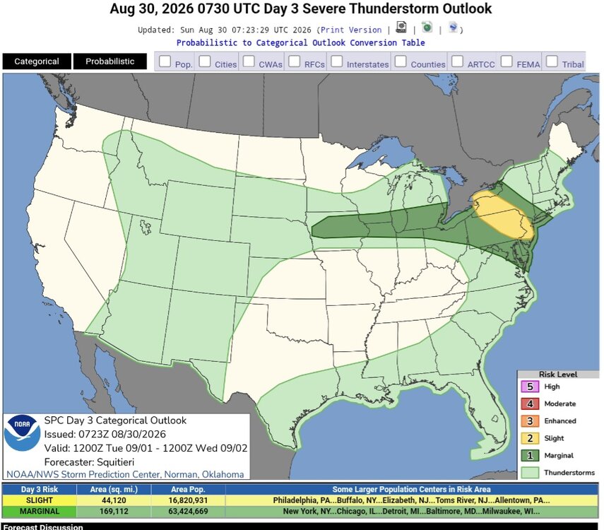
-
 https://cloindia.shop/# how to buy cheap clomid no prescription
 -
 I wouldn't completely rule out storms, but probably more elevated if they do occur and obviously the better chances for severe further SW based on current guidance.
 -
Glad we don't live there.
-
Thread] [1/6] I think we can now confidently say that France is going through the greatest national agricultural disaster since 1945. Without public aid, 30,000 to 35,000 farms could find themselves in bankruptcy, which is nearly 10% of French agricultural holdings. That's monstrous. The exceptional weather conditions we're experiencing today are getting closer to what will become much more frequent, or even ordinary, in the coming decades. 2026 will be in line with the average for 2050. We'll see even hotter and more extreme years than 2026. The realization is therefore becoming hard to avoid: our agricultural model is not sufficiently prepared for the climate change that's coming. It's also the result of a collective political failure: successive governments haven't fully grasped the scale of the upheavals that climate change is already imposing on our agriculture, and will impose tomorrow. It's no longer just about repairing the damage after every drought, heatwave, or poor harvest. We now need to undertake a structural transformation of our agriculture. Here are the most reliable yield losses I could find compared to the average of the last 5 years (only for spring and summer crops). Rate this translation:
-
ivermectin cost canada and stromectol where to buy ivermectin syrup https://toolbarqueries.google.com.bn/url?q=https://iverindia.shop stromectol where to buyor http://www.garmoniya.uglich.ru/user/jyavibglax/ buy stromectol online uk [url=https://www.kultur-bad-vilbel.de/goto/?u=http://iverindia.shop]price of ivermectin[/url] stromectol medicineand [url=https://cyl-sp.com/home.php?mod=space&uid=170997]ivermectin 3 mg tabs[/url] stromectol pills
-
ivermectin cost canada and stromectol where to buy ivermectin syrup https://toolbarqueries.google.com.bn/url?q=https://iverindia.shop stromectol where to buyor http://www.garmoniya.uglich.ru/user/jyavibglax/ buy stromectol online uk [url=https://www.kultur-bad-vilbel.de/goto/?u=http://iverindia.shop]price of ivermectin[/url] stromectol medicineand [url=https://cyl-sp.com/home.php?mod=space&uid=170997]ivermectin 3 mg tabs[/url] stromectol pills
-
I estimate 1.77C is needed to break a record this year vs Jacobson's 1.84. In any case August's warmth has made a record likely this year and put 2023's gobsmacking September of 1.74C in play. Sept 2023 is still the highest ERA monthly anomaly.
-
What a summer for SW CT.. While there remains forecast uncertainty this far out, it appears the region will have the potential for convectively induced heavy rain and embedded thunderstorm activity. WPC currently has the area under a marginal risk of excessive rainfall Monday through Thursday morning, and SPC persists in placing the area in a 15 percent chance of severe weather on Day 5 (Wednesday) which is rare to see this far out in time. So the middle of next week will bear watching as PWATs are progged to climb into the 1.5-2 inch neighborhood by Tuesday into Thursday
- Today
-
Augdewst 2026: Summer's Last Stand
CoastalWx replied to Prismshine Productions's topic in New England
I like the gfs op at 00z and 06z giving CA some canes. -
Augdewst 2026: Summer's Last Stand
CoastalWx replied to Prismshine Productions's topic in New England
Fortunately nobody cares -
Looks like a multi-day event coming for the region. SPC even mentions svr risk on DY6 psbl! Hot upper ridge w/ axis to our W in WNW to NW flow and we are on the edge of capping and stronger flow aloft. Can do quite well in such set ups due to an EML! Highest risk and axis just N now is actually good b/c many times initial convection pushes the boundary farther S than any model shows, so that may place it right over the region instead. We saw this a few weeks back except everything was pushed well S into the Carolinas and we missed out on a multi-day svr event in the DMV.
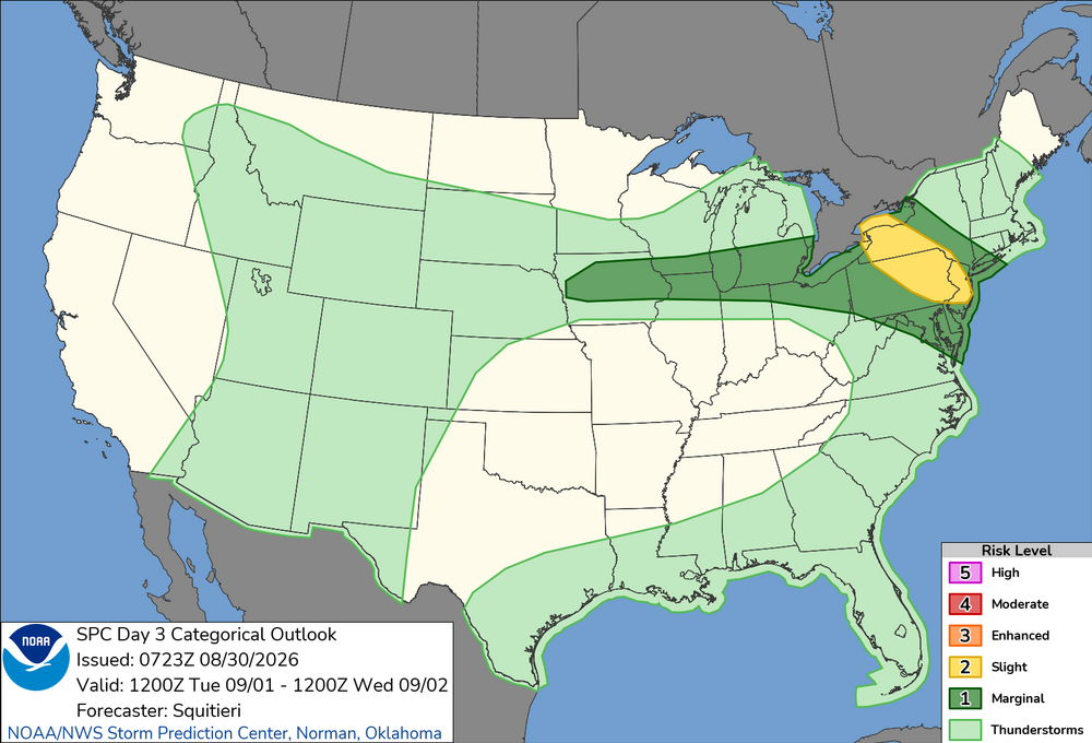
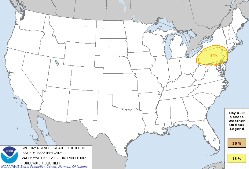
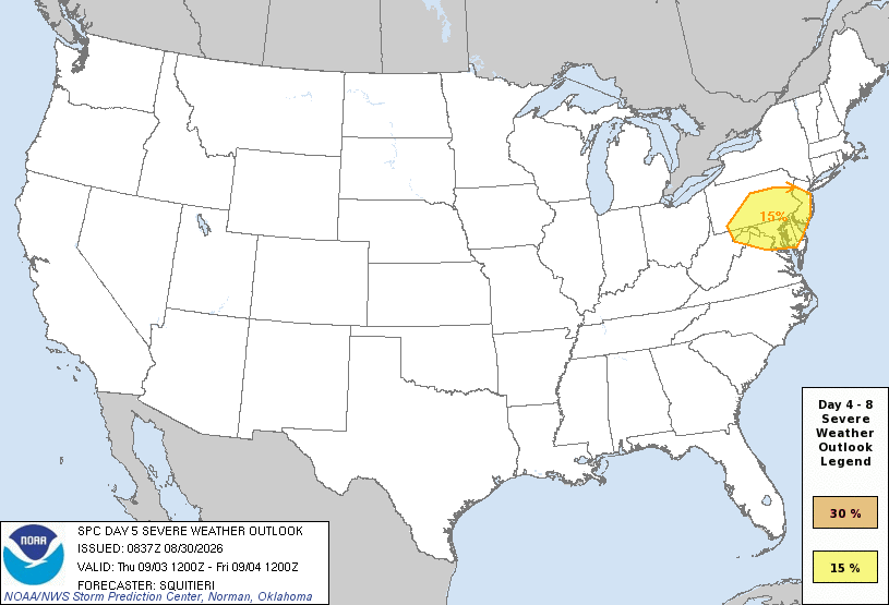
- 2,244 replies
-
- 2
-

-

-
- severe
- thunderstorms
- (and 7 more)
-
get clomid: Clo India Pharmacy or buying cheap clomid without dr prescription
-
2026-2027 Record-breaking El Nino
bluewave replied to Stormchaserchuck1's topic in Weather Forecasting and Discussion
I think the recent leveling off of Nino 3.4 SSTs was a result of the record WWBs pushing the warm pool further east than originally forecast. The latest EPS extended now has a warmer Nino 1+2 forecast than the seasonal model on August 5th was indicating by October. So it will be interesting to see what the ECMWF seasonal looks like when it updates on September 5th. -

Augdewst 2026: Summer's Last Stand
vortex95 replied to Prismshine Productions's topic in New England
@weatherwiz and @CoastalWx are "mad" it is all SW! SPC even said DY6 could have svr in the same area!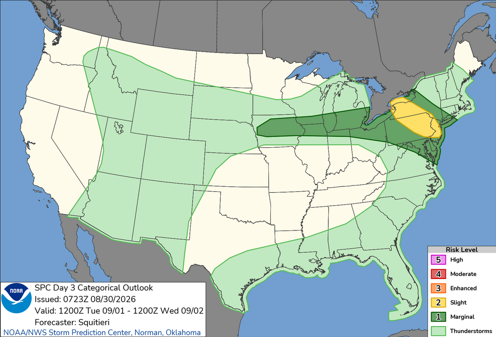
-

Monday, August 31 - Wednesday, September 2, 2026 Convective Episodes
Modfan2 replied to weatherwiz's topic in New England
Yup, wagons south. Congrats NJ -
Not looking like storms anywhere in New England now
-

Septorcher 2026 Discussion - Endless Summer
Brewbeer replied to Damage In Tolland's topic in New England
is the thread title a forecast or wishful thinking ?