All Activity
- Past hour
-

Central PA Fall Discussions and Obs
canderson replied to ChescoWx's topic in Upstate New York/Pennsylvania
CTP has removed any chance of rain from my forecast today. Ha! .1”-.25” forecast Monday but I’d bet it’s less. -
-

The return of the elusive Nor'easter. Drought buster or bust?
Terpeast replied to dailylurker's topic in Mid Atlantic
0.07”. I was out this weekend so I didn’t track this storm, so does anyone remember which models correctly forecasted the evolution of this coastal storm? Take note of that for winter. -
 3km NAM looks to be only 12 or 06Z run that has any idea based on current radar but even it looks like it may not be aggressive enough with the NW push today
- 369 replies
-
- 1
-

-
- heavy rain
- damaging wind
- (and 2 more)
-
.thumb.jpeg.f5c6ba9d911ec96b3b124f8606aee58e.jpeg) IBSP peak gust of 54 mph. Granted that sensor is about 40 feet above ground.
IBSP peak gust of 54 mph. Granted that sensor is about 40 feet above ground.- 369 replies
-
- 1
-
-
- heavy rain
- damaging wind
- (and 2 more)
-
 Everywhere under the rain shield per OKX/DIX/JFK/EWR radars its raining with up to 0.2" past 3 hours in se NJ. mPing would break helpful next 36 hours.
- 369 replies
-
- 1
-
-
- heavy rain
- damaging wind
- (and 2 more)
-
fwiw: gust up to 50 MPH Little Egg Harbor NJ. 3" limbs reported broken at 1055A vicinity Orange NJ per mPing. Unsure of the mPing report Follow NWS... coastal situation appears on previous NWS track.
- 369 replies
-
- 1
-
-
- heavy rain
- damaging wind
- (and 2 more)
-

Spooky Season (October Disco Thread)
bristolri_wx replied to Prismshine Productions's topic in New England
Sure they are available at troll-tiger.com -

-

The return of the elusive Nor'easter. Drought buster or bust?
Mrs.J replied to dailylurker's topic in Mid Atlantic
I have both my college kids home unexpectedly this weekend. Putting a new perspective on Mother Nature. We get thrown curve balls in weather much like we do in life. -

E PA/NJ/DE Autumn 2025 Obs/Discussion
Birds~69 replied to PhiEaglesfan712's topic in Philadelphia Region
Hope it's not a sign of things to come. This would have been a real Debbie downer if snow was involved... .. -
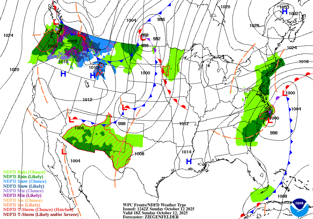
 Throughout the preceding work week pretty much every model showed us getting a soaking from the coastal system. Some only showing a region wide inch while others were giving us 2-5 inches. The models held on to that until the 48-72 hour mark before they suddenly and epically collapsed. This has happened more often than not since spring 2023, and there hasn’t been a true wet pattern since 2022. Every big event since then was either a one off or the region gets hit but it underperforms in a way that gives winners and losers, often with a significant cut off gradient. This has been a resilient dry pattern. Usually Niña induced dry patterns end when the Niña dies but it survived the end of the 2023 Niña, stuck around during the transition to the 2024 Niño, precip underperformed during the Niño, when last year’s Niña ended it paradoxically intensified, and here we are now in the latest of a series of rain event busts. It seems as if we need the planets to align to get a decent system. There’s quite a few mechanisms that are required to give us big snows so I can understand why we can have problems in winter, but almost everything that we need for snow not the case for rain. It’s not supposed to be this hard to get rain here. Its like a switch flipped in 2023.
 -
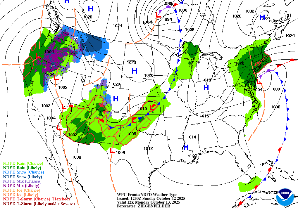
Not really a good cast here. Misread the unfolding pattern here. Picked up on LP in the E, but that was a Nor' Easter well E. LP in the W area shoots N as HP slid E.

-
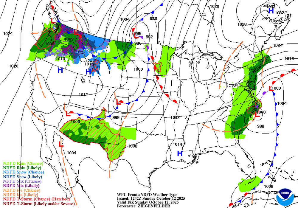
 East of the city will do fine and the shore will get hit hard
- 369 replies
-
- 1
-
-
- heavy rain
- damaging wind
- (and 2 more)
-
 Would just be a continuation of every event underperforming, if it does turn out that way. Been going on for awhile now .
 -
 East of William Floyd will do very well rain wise. Rest of LI, you can see the precip shield erode as it climbs N.
- 369 replies
-
- 1
-

-
- heavy rain
- damaging wind
- (and 2 more)
-
 good question - do we share with other countries models our data ? how does that all work ?
 -
 And hold on, global models like the Euro use the USA's balloon data? Why was the Euro paywalled then if they were using taxpayer funded initialization data?
 -
Spooky Season (October Disco Thread)
SnowGoose69 replied to Prismshine Productions's topic in New England
I do believe there is some correlation historically to that feature being there in mid October to the winter though its better to see it now than on 11/30. In 1993 I think it was basically there the entire period from about 10/15-12/15 before the pattern totally flipped -
this thread is a good practice run here for the winter storms ahead - taking what you just mentioned into account too.........
- 369 replies
-
- 1
-
-
- heavy rain
- damaging wind
- (and 2 more)
-
The storm is on the east coast for over a day. You're telling me there are balloons not launching on the east coast? I thought it was only a few balloons in Alaska several days ago.
-
 This goes way before the government shutdown though. A few years of all of a sudden piss poor model accuracy imo.
- 369 replies
-
- 1
-
-
- heavy rain
- damaging wind
- (and 2 more)
-
this is a now casting event - models should be taken with a grain of salt especially since they are not receiving full data input since the gov shutdown began
-
Will there be another nor’easter chance or will we have to wait another 8 years?