All Activity
- Past hour
-
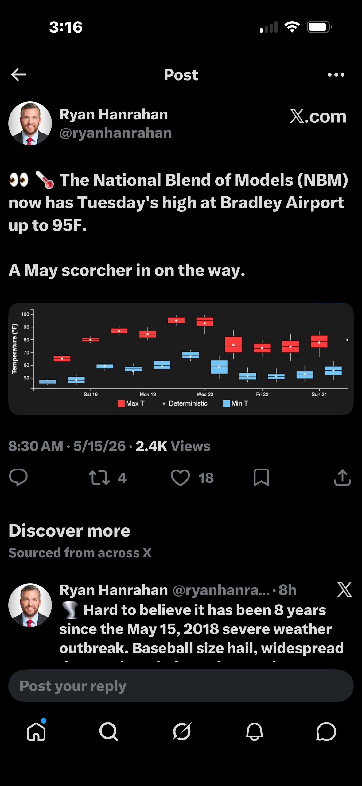
It will turn noticeably warmer during the weekend. Parts of the area could reach or exceed 80° tomorrow. Sunday will be even warmer with temperatures topping out in the middle and perhaps upper 80s. Even as Monday will be a bit cooler than Sunday, the warmth will likely continue through the middle of next week. Temperatures could rise into the upper 80s and perhaps the lower 90s on Tuesday and Wednesday. Wednesday will likely be the hottest day so far this year. Thursday will still be warm. Afterward, it will turn much cooler. The ENSO Region 1+2 anomaly was +1.6°C and the Region 3.4 anomaly was +0.9°C for the week centered around May 6. For the past six weeks, the ENSO Region 1+2 anomaly has averaged +1.50°C and the ENSO Region 3.4 anomaly has averaged +0.55°C. El Niño conditions are rapidly developing and will likely be in place in the next few weeks. The SOI was -18.21 today. The preliminary Arctic Oscillation (AO) was +1.462 today. Based on sensitivity analysis applied to the latest guidance, there is an implied near 63% probability that New York City will have a warmer than normal May (1991-2020 normal). May will likely finish with a mean temperature near 64.0° (0.8° above normal). Supplemental Information: The projected mean would be 1.5° above the 1981-2010 normal monthly value.
-
No one did. Parts of Maine and New Hampshire are in moderate to severe drought. Just saying what the NWS is saying.
-

Spring 2026 Pattern Discussion Thread
KakashiHatake2000 replied to Carvers Gap's topic in Tennessee Valley
At least 90s I guess are sort of on time not early so there’s that although not really sure also apparently the heatwave can lead to rain chances supposedly hope that is for the entire state and southeast also other places that need it at least according to WSMV 4 in middle tn . -
Indeed
-
CPC going with El Nino almost to a T
-
@CT Rain wakes up in the middle of the night thinking about this day.
-
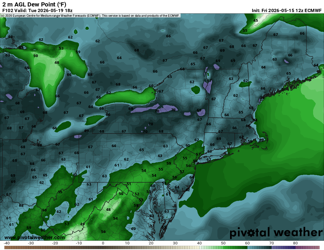
Rainfall potential, despite the warmer airmass next week is pathetic. Maybe June will deliver.
-
Clouds hanging on
- Today
-
Low 80's in town. Got some sun today. Feels great! Winds picked up this aftrn gusting to 30+ out of the W. Still a milky sky from the dust aloft.
-

Central PA Spring 2026 Discussion/Obs Thread
pawatch replied to Voyager's topic in Upstate New York/Pennsylvania
Not so sure we will see 90’s on Tuesday north of I-80. -
Well see you next November for winter coverage because I’ve already canceled Atlantic Hurricane Season 2026 Don’t think I moved back yet but I def don’t remember this day.
-
Little bit of temp bust today, it was suppose to be low 70s and at 3pm it's only gotten to 65
-

2026-2027 Strong/Super El Nino
FPizz replied to Stormchaserchuck1's topic in Weather Forecasting and Discussion
Thanks. I thought predominantly from like Nov-Now minus like a 6 week break it wasnt like the map above. Carry on... -

Central PA Spring 2026 Discussion/Obs Thread
TheDreamTraveler replied to Voyager's topic in Upstate New York/Pennsylvania
I'm not really bitching about it I guess just having something to chat about that's relatable lmao I don't even really get in the water much at all. My main thing for even saying it is the fact those 2 days will probably be 2 of the hottest days of the entire summer and it happens this early instead of later which is stupid imo. Like if I ever do get in the pool it's only on really hot days like that but I get there's going to be a shit ton of days to get in it lol -

Central PA Spring 2026 Discussion/Obs Thread
WmsptWx replied to Voyager's topic in Upstate New York/Pennsylvania
Holy fucking Christ, you people are exhausting. It's May 15th. I've always considered swimming in May a bonus. It's been 50 degrees for the last month, that pattern seems to be breaking (and it's going to be in the low 60s next weekend so it's not even going to be extended warmth) and here we are. Bitching about the pool water. I may need to take a break. -
Hammer hitting it hard
-
Gonna need it trend a little warmer aloft I think for widespread 95+. Euro/GFS are around 18c or so at 850. I wanna see 19-20c with good mixing to lock 95+. Either way low 90s should be doable
-

2026-2027 Strong/Super El Nino
Stormchaserchuck1 replied to Stormchaserchuck1's topic in Weather Forecasting and Discussion
CPC 3-4 Week forecast going with an El Nino precip pattern.. should be interesting to see if it verifies, it's been running dry -
Yep...
-

2026-2027 Strong/Super El Nino
LakePaste25 replied to Stormchaserchuck1's topic in Weather Forecasting and Discussion
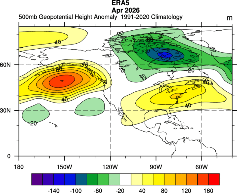
March and April were warm in the east. March was +6 here at ERI and April was +5.1.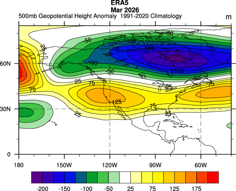
-
It’s got more mixing down there with larger mass flow off land versus slightly off water in SNE. Looks like a roaster to me away from the S Coast so we’ll see how it plays out.

-
Will be 95+ BDL/ CEF/ Merrimack Valley
-
storm prospects naso great imby but glad to be back in summer mode
-
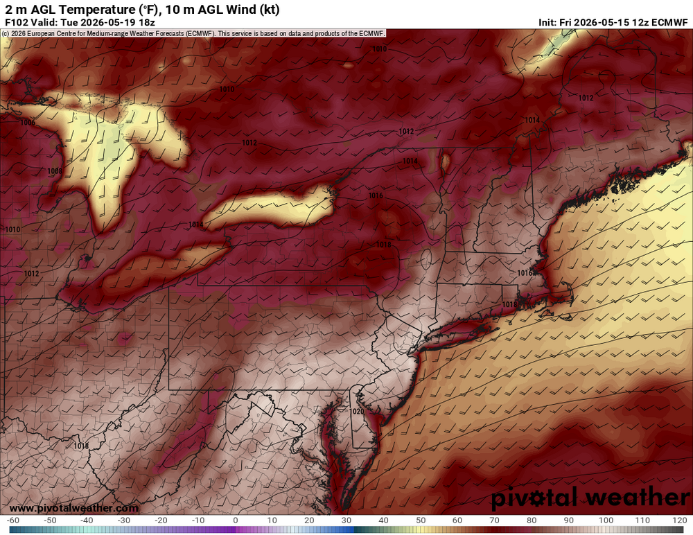
Euro's putting up big heat numbers in NYC's metro west and N NJ on Wednesday.
-
62 and overcast. Best climo.