All Activity
- Past hour
-
I know, it's odd that the operational would have to clearly be a huge outlier. Hasn't it learned anything?
-
Happy Thanksgiving!
-

Central PA Fall Discussions and Obs
Festus replied to ChescoWx's topic in Upstate New York/Pennsylvania
When was the last time it snowed in Central Pennsylvania on Thanksgiving? To find the last measurable snowfall, we have to go back over 35 years. According to the National Weather Service out of State College, the last measurable snow in the Harrisburg region occurred on Thanksgiving 1989 when 1.2 inches of snow fell. The maximum snowfall the Harrisburg area received on Thanksgiving in the last 50 years occurred in 1971. That was when 2.8 inches fell on Thanksgiving. That same year also set a record with the most snow on the ground during Thanksgiving, which was six inches. -
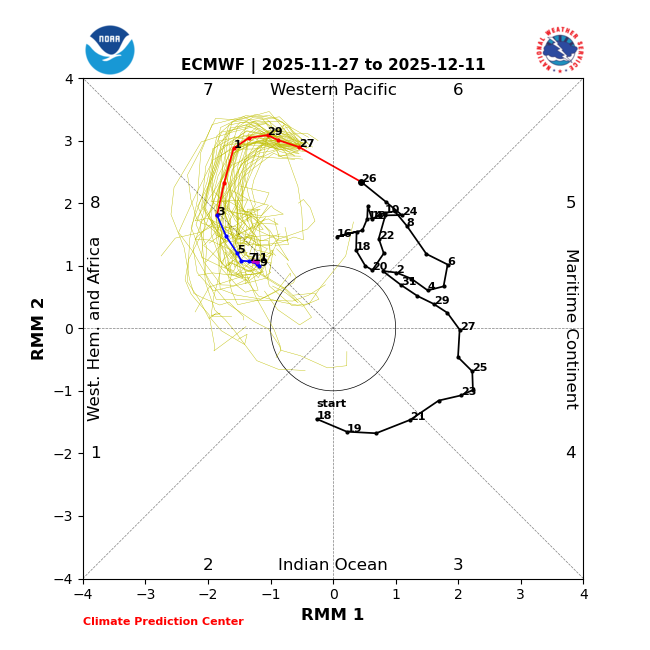
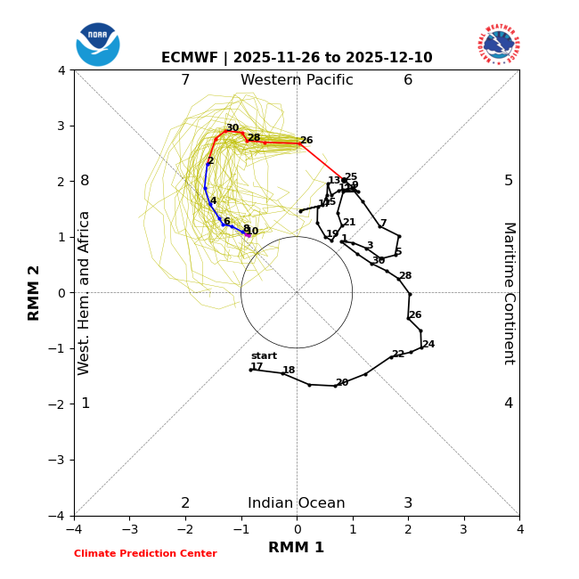
Yesterday’s (11/26) 2 week EPS (through 12/10): barely made it to phase 8 on Dec 5th-6th before circling back to phase 7 (extended showed it made it back to phase 8 12/13-27+): Today’s (11/27) 2 week EPS through 12/11: gets to phase 8 on 12/3 and stays through the end of the run (12/11), meaning a 9+ day long phase 8, which would be the longest Dec phase 8 at least since the 10 day long phase 8 of 1989: (tomorrow’s ext EPS will show the total length) In summary, all MJO forecasts are more favorable with regard to phase 8 vs yesterday.

-

Nov 28-30th Post Turkey Day Wintry Potential
mimillman replied to Chicago Storm's topic in Lakes/Ohio Valley
This looks like a solid 6-10” area wide with some 12” lollis probably favored over eastern Iowa or northwestern Illinois. I’m out of town this weekend so will miss this one unfortunately. Get back Sunday early evening so shouldn’t be an issue on the return and will get to enjoy the deep winter feel as we get into December. For what it’s worth, I don’t think I’ve ever witnessed a November in proper Chicago (not ORD or the burbs) with this much snow. 2018 was great for the suburbs but downtown it was mostly slop and rain. Nice change of pace to start winter. -
That was one hell of a season for EMA and RI and even CT. It started out as a complete ratter. We were going into late Jan with virtually no snow and for many climo sites it was looking like a top 5 or top 10 worst winters of all time and did a complete 180 with Boston ending up with snowiest winter on record. Not only did we get a ton of snow from Jan 24-late Mar but it never rained or had a period of significant warming, Feb ended up being the coldest on record for many areas and we went nearly 2 months with a solid deep snow pack right down to the coast. I have mixed feelings about that winter despite picking up like 65". There were many busts, especially Jan 26-27 and the first half of the winter was awful. But there was certainly a lot to like as well.
-

Central PA Fall Discussions and Obs
canderson replied to ChescoWx's topic in Upstate New York/Pennsylvania
Happy Thanksgiving, all! -

Central PA Fall Discussions and Obs
Mount Joy Snowman replied to ChescoWx's topic in Upstate New York/Pennsylvania
Low of 39 with .1” of rain. Thankful for this crazy group of weather freaks. Happy Thanksgiving to you and yours! -

2025-2026 Fall/Winter Mountain Thread
Maggie Valley Steve replied to Buckethead's topic in Southeastern States
Happy Thanksgiving everyone! My low was 27 this morning and the snow guns are blowing all over Cataloochee. Webcam shows a very base was blown overnight! Clouds have rolled in with a bit of virga as well. -

December 2025 regional war/obs/disco thread
moneypitmike replied to Torch Tiger's topic in New England
For the love of God--no one start a thread before Sunday. -

Nov 28-30th Post Turkey Day Wintry Potential
michsnowfreak replied to Chicago Storm's topic in Lakes/Ohio Valley
Very light dusting of snow this morning. But with Saturdays snow, this will be the 3rd Thanksgiving weekend in a row to have a blanket of snow. -

Central PA Fall Discussions and Obs
WmsptWx replied to ChescoWx's topic in Upstate New York/Pennsylvania
Starting to read about a second significant disruption of the PV in late December. Could this be a wall-to-wall winter? -
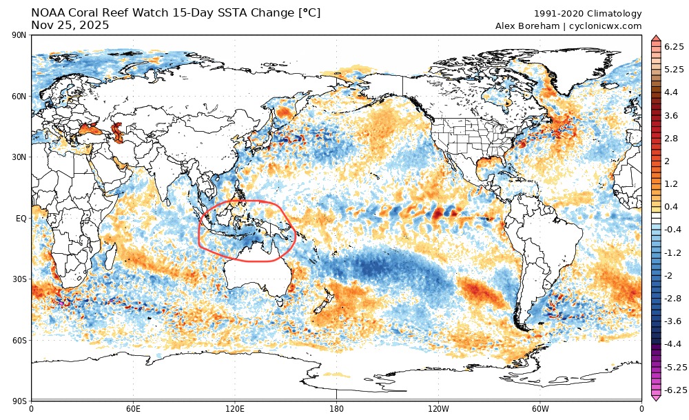
Yeah, according to hovmollers the models are trending towards weaker forcing at 6/7 after Dec 7. Between now and Dec 7, we have a clean mjo 8 pass. Then weak forcing reappears at 6/7, which is strongest with gefs. But even the gefs begins to propagate that eastward after Dec 7-10. So we may yet get another mjo 8 pass soon afterward. MC ssts also have been cooling recently:
-
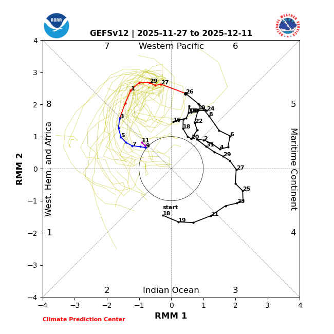
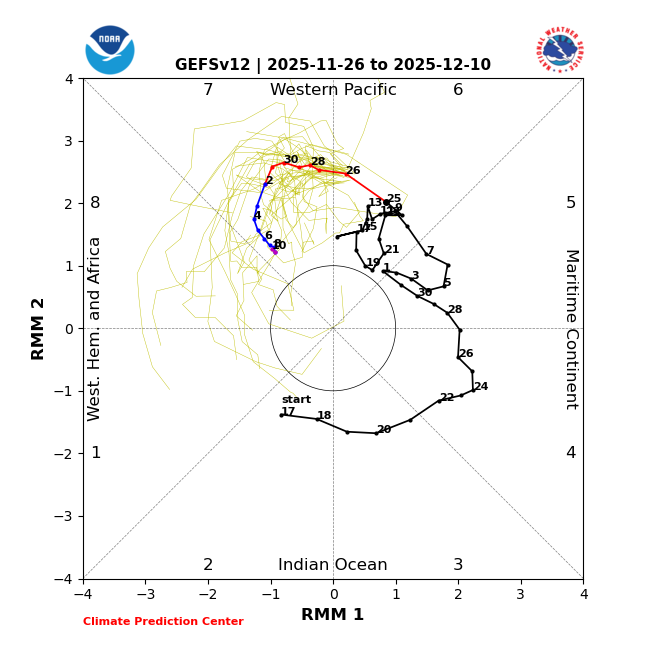
Yesterday’s (11/26) 2 week GEFS (through 12/10): didn’t make it to phase 8 (extended showed it made it but not til 12/13): Today’s (11/27) 2 week GEFS through 12/11: already makes it to phase 8 on 12/3, which is TEN days earlier than yesterday. It remains in phase 8 through the end, meaning it would be a 9+ day phase 8, the longest Dec phase 8 since 1989:
-
Hard to cool with cloudy skies and 30-40mph wind gusts.
-
Great insight as usual Walt. NWS OKX AFD seems to be on the fence in issuing a wind advisory for Friday and does mention a slight chance of showers/flurries. I highlighted the passage to make it easier: SHORT TERM /FRIDAY THROUGH SATURDAY NIGHT/... Key Point * Friday winds gust to 40 to 45 mph, possibly higher, close to 50 mph at times. * Friday still very cold with high temperatures upper 30s to lower 40s. Max wind chills mostly in the lower 30s. The low in Quebec makes its way towards the Canadian Maritimes without much change in strength with its central low pressure on Friday. The pressure gradient during the day Friday between this low and high pressure well to the southwest becomes the most tight, indicating an even more gusty westerly flow. This will be conveyed through a deeper mixing layer and steeper lapse rates which are shown in the forecast model BUFKIT soundings. There is some indication also of some narrow sliver of elevated CAPE and with positive vorticity advection could have a few rain and/or snow showers for parts of the region. POPs are just slight chance for this. The core of the 850mb cold pool will be across the region so made some adjustments to NBM to account for this. Went higher than NBM for clouds and POPs as well as winds and lower than NBM for temperatures. NBM 90th percentile winds were used and even with these were manually adjusted up to better match up with forecast soundings from BUFKIT especially with deep vertical mixing. The current forecast has wind gust maxima of 40 to 45 mph, just below wind advisory criteria. Cannot rule out a few wind gusts to wind advisory thresholds, near 50 mph Friday. At this time, still too early and not high enough confidence to go with wind advisory for Friday but chances are slowly trending up. 06Z MAVs have trended slightly higher with sustained winds Friday afternoon for some sites compared to the 00Z MAVs. Would also like to see LAMP gusts indicate some mid to upper 30s for wind gusts to increase confidence in wind advisory for Friday. BUFKIT already indicating a few spots late afternoon into evening mix up to near 800mb with 45 kt at top of mixed layer. The 40kt wind gust potential in the HRRR fields has expanded comparing the 00Z HRRR run to the 06Z HRRR run. The wind gust potential with the 00Z run only indicated some areas of 35-40 kt wind gust potential within the region for Friday mainly in the easternmost part of LI Sound and now covers most of LI Sound and along more coastline. Forecast high temperatures Friday are mostly in the upper 30s to lower 40s with wind chills at most in the lower 30s for most locations.
-

Central PA Fall Discussions and Obs
Blizzard of 93 replied to ChescoWx's topic in Upstate New York/Pennsylvania
CTP is starting to mention the Tuesday chance. .SYNOPSIS... * Gusty west to northwest winds and much colder temperatures to end the week * Lake effect snow will result in significant Thanksgiving holiday travel disruptions across northwest Pennsylvania * Scattered snow showers and a few squalls will impact the weather across the Central Mtns, Laurel Highlands and possibly the Middle Susquehanna Valley Thanksgiving Day into Friday * A few periods of snow (Northern PA) and snow/or a wintry mix (Southern PA) late Saturday Night and Sunday * A more significant/widespread winter storm possible Tuesday and Tuesday night -
On the bright side today shows the MJO getting to phase 8, which reflects the early snow threats to our N/W zones
-
IMO its interesting for the mid week storm that the ensembles of the GFS and Euro are not amped up like the OPS. Also the Euro AI is still southeast with precip barely making it into the Metro as shown below
-
That lightest gray patch is a bit north of you, and right over me. It's surprising how often modeled snowfall includes that Fryeburg-Danforth hole. Fortunately, it doesn't verify all that often.
-

December 2025 regional war/obs/disco thread
Great Snow 1717 replied to Torch Tiger's topic in New England
That map looks highly suspect... -
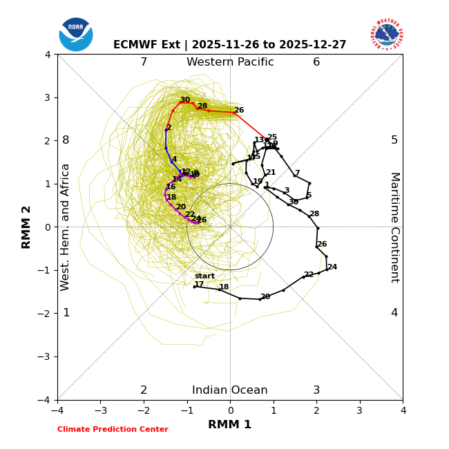
Yesterday’s (11/26) EPS 2 week MJO forecast through Dec 10th: was then curling back away from 8 after barely getting into it and we were wondering whether it would ever get back to phase 8: Yesterday’s (11/26) EPS extended, which adds 12/11-27: had a 15+ day phase 8 12/13-27, which would be the 2nd longest phase 8 on record for any month (2nd only to the 18 day long phase 8 of Dec-Jan 1975-6) and the more favorable for cold weak to moderate amp (vs strong) to boot:
-
37 for the low. Another weak sauce cool shot.
-
Wow ai ensembles lol. Absolute eye candy. Do I fall for it? Hook line and sinker!!! U know the drill.
-
High is in a bad spot. Southeast winds just eroding the cad.


