All Activity
- Past hour
-
I’d like to see that southern stream energy get absorbed into that northern stream sooner, so we can have that bowling ball mature sooner and be an able to wrap in all that southern energy. If, not we are left with this discombobulated mess of a storm. and has been said before, that kicker is there to make things just that much more complicated.
-
Temps - after around 5 straight days/nights above freezing - have finally lowered enough to turn the Wisp snow guns on. Workers were struggling to keep enough snow at the lift exit areas the last few days, but overall managed to keep things going quite nicely while they saw lots of melting. Fortunately that period is behind us. Today's squall parameters and overall setup calls for a 3-6 from NWS, but the setup, imo, is more marginal with just a few inches outside of the most favored areas. Regardless, better than the 59 and high humidity I saw two days ago. Hope I am wrong about accums because we desperately need it (for legit purposes as well as my own grumpiness for April-esque mud everywhere).
-

January 2026 Short/Medium Range Thread
Holston_River_Rambler replied to John1122's topic in Tennessee Valley
Some of the snow showers dropping out of KY have Special weather Statements: -

E PA/NJ/DE Winter 2025-26 Obs/Discussion
Duca892 replied to LVblizzard's topic in Philadelphia Region
As always this is from a no nothing like me, but I’m kind of throwing in the towel on anything warning level this week. Just seems to be pretty consistent now that it won’t blow up in time or it’s moisture starved -

January 2026 regional war/obs/disco thread
Baroclinic Zone replied to Baroclinic Zone's topic in New England
I’d like to see that southern stream energy get absorbed into that northern stream sooner, so we can have that bowling ball mature sooner and be an able to wrap in all that southern energy. If, not we are left with this discombobulated mess of a storm. -

January 2026 Medium/Long Range Discussion
SomeguyfromTakomaPark replied to snowfan's topic in Mid Atlantic
What could go wrong? -

January 2026 regional war/obs/disco thread
CoastalWx replied to Baroclinic Zone's topic in New England
It’s hilarious that shortwave struggles to generate advisory snow. What a winter. -

January 2026 regional war/obs/disco thread
Great Snow 1717 replied to Baroclinic Zone's topic in New England
I think this goes far beyond a lull...this has been a multi year significant snow drought... -
Columbia imby 1.11” Jan 9-10.
-
Storm thread for Thursday/friday going to be meltdown city if it plays out like the overnight runs. Waiting for a changeover from rain….blobby precip field, a few people getting raked while others get flurries…oh man it will be rough.
-
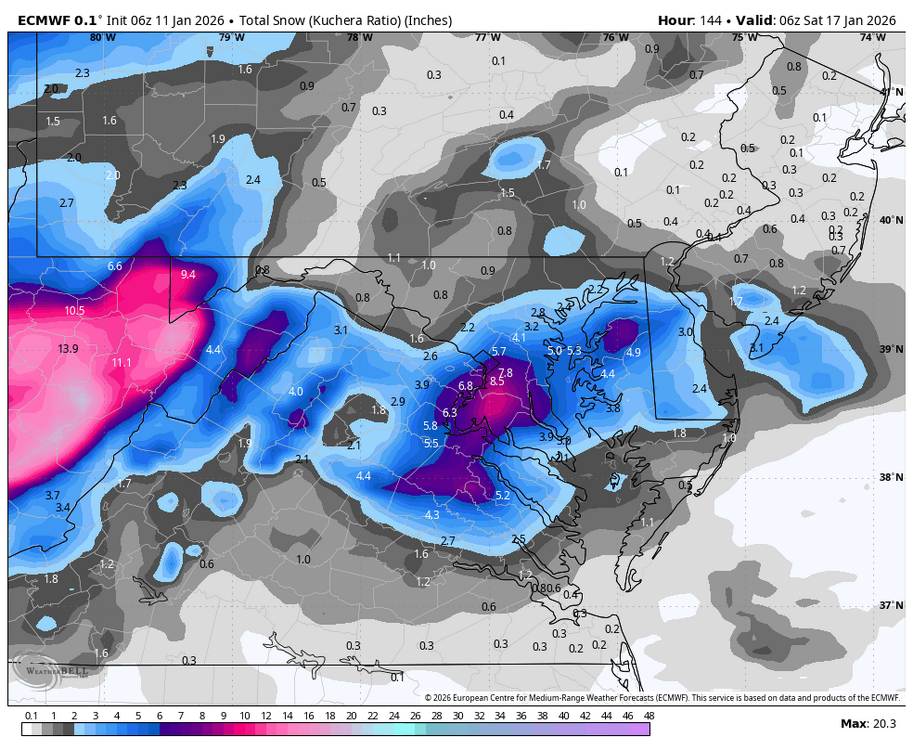
Euro finally gets close to the GFS and then the GFS looks awful at 6z lol
-
Looks like maybe a few. Gas up the leaf blower.
-
January 2026 regional war/obs/disco thread
CoastalWx replied to Baroclinic Zone's topic in New England
Let’s get a 1-3” event -
Looks like we can score some goods on storm 1. Cool cool. Let’s reel in that appetizer. Storm 2 though—at the end of the 0z Euro—can’t say I’ve ever seen anything like it. Weenie dreams!! Holy F!
-
what about the 6Z euro
-

January 2026 regional war/obs/disco thread
Damage In Tolland replied to Baroclinic Zone's topic in New England
She gonna come just not big -
A 1 county sized jackpot zone surrounded by a 1-3” region the size of Delaware lol
-
1.91 storm total. Over night runs still lead me to think options are on the table. The official WPC guidance has one day that is mentioned on Friday for the northern mountains. Like WNC-fort said, by early to mid week we should know. But looking like a cake job to our west in the mountains right now.
-
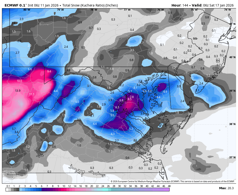
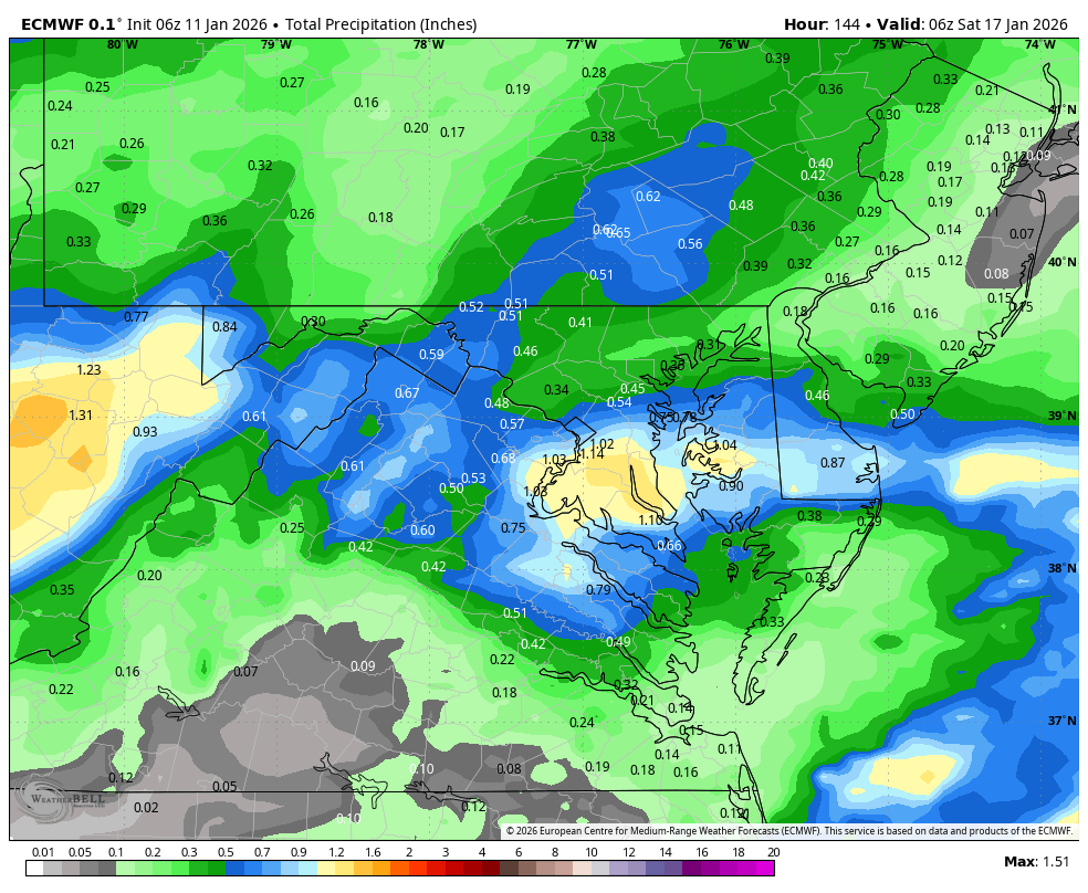
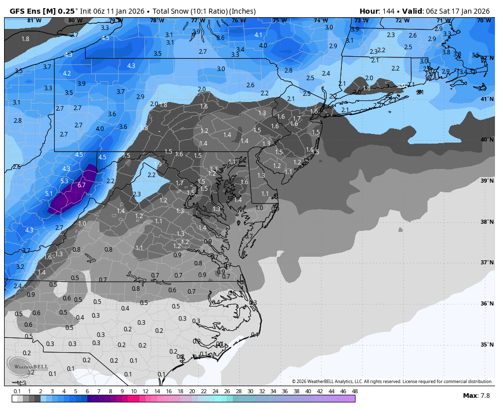
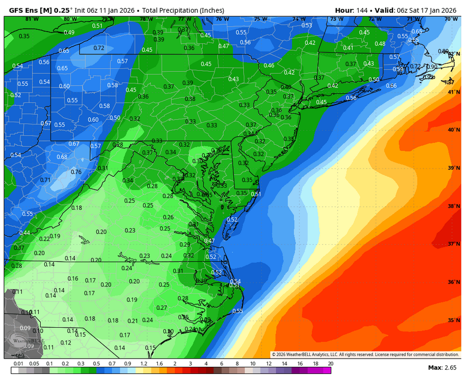
WB 6Z EURO (rain limits accumulations)

-
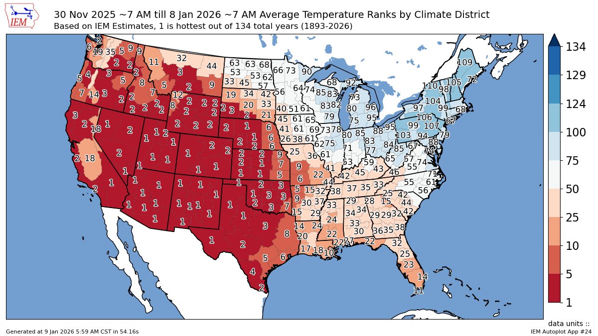
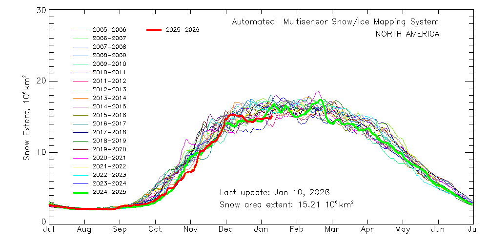
The best snow cover extent relative to the means so far this winter was back in late November and early December prior to the big warm up for much of the CONUS outside the Northeast and Great Lakes.

-
January 2026 regional war/obs/disco thread
CoastalWx replied to Baroclinic Zone's topic in New England
Yep. It’s going to be hard to get a siggy event I think. -

January 2026 regional war/obs/disco thread
Kitz Craver replied to Baroclinic Zone's topic in New England
GFS too - Today
-
January 2026 regional war/obs/disco thread
CoastalWx replied to Baroclinic Zone's topic in New England
I think the one thing that concerns me the most is that all the good moisture that this thing needs to wrap in is way offshore. That’s why the euro is fairly meager with precip. It’s straining to get anything into the conveyor belts and dump precip. That I don’t like. -
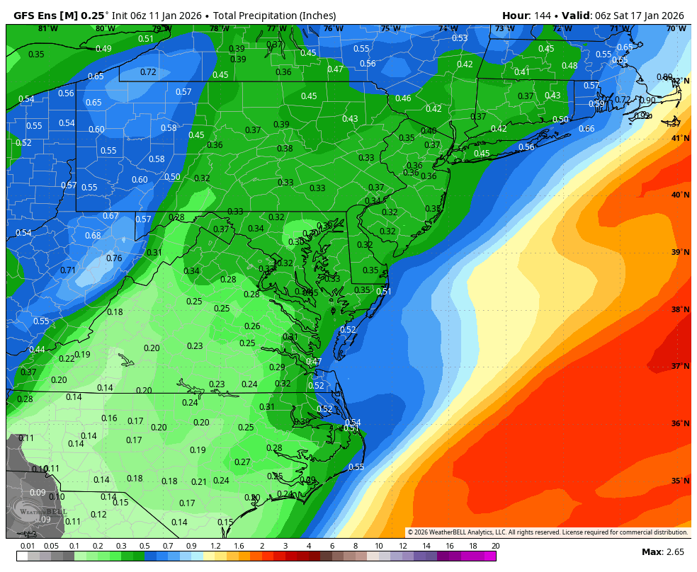
WB 6Z GEFS is a little better....

-

Winter 2025-26 Medium/Long Range Discussion
A-L-E-K replied to michsnowfreak's topic in Lakes/Ohio Valley
Duster days are here again
.thumb.JPG.418e8a9a2902ae687ec35ff4bc0e038e.JPG)