All Activity
- Past hour
-
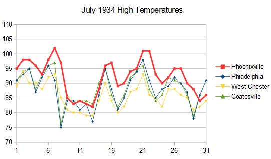
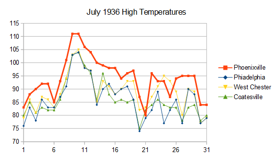
We have a good example in Chester County PA. Here are high temperatures for July 1934 and 1936 for 4 local stations. Phoenixville ran much warmer than the other stations probably due to poor shelter placement. Phoenixville also carried over hot temperatures to the next day when the other stations cooled. This shows that the Phoenixville max/min thermometer was flipped near the time of peak temperature while the other stations were not. Phoenixville completely dominates the # of 95 and 100F days in Chester County in the 1930-40s, but the data is spurious. This is why I don't trust plots of historic max temperatures in the US, unless the data has been scrutinized for bad data. Only takes one or two bad apple stations to create a spurious result.
- Today
-
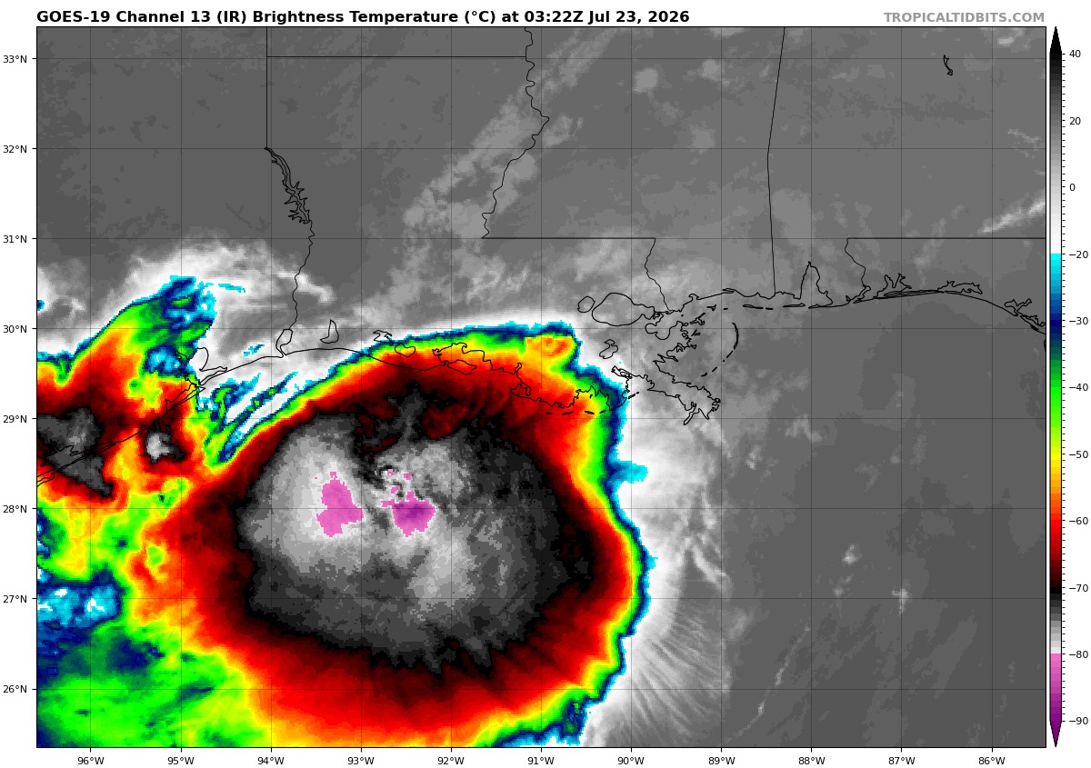
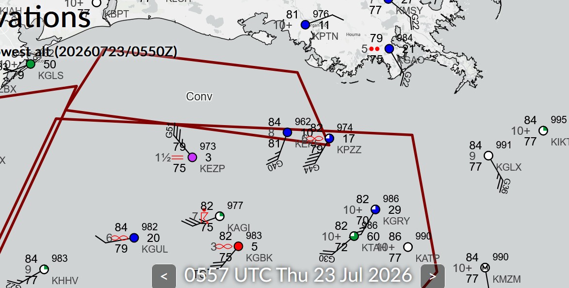
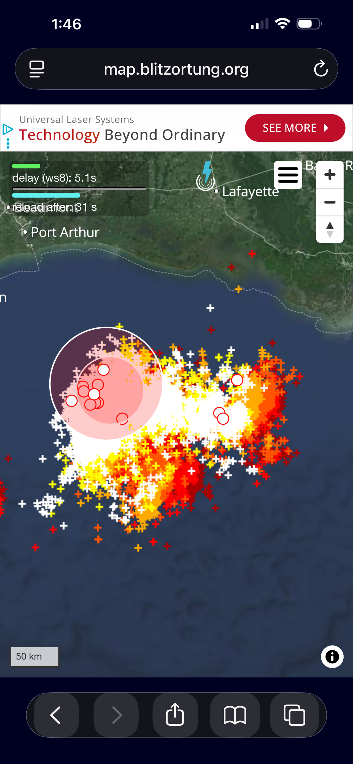
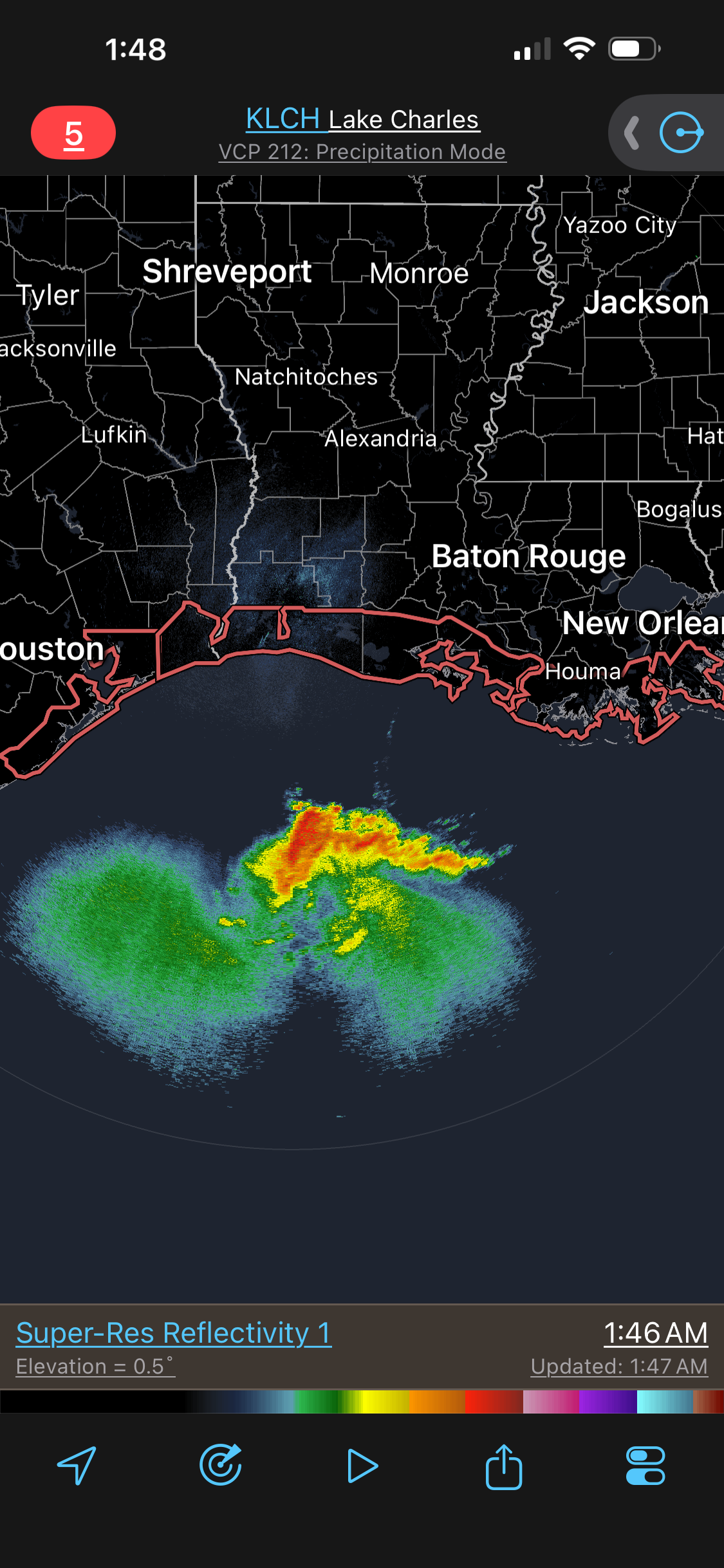
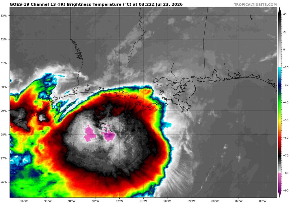
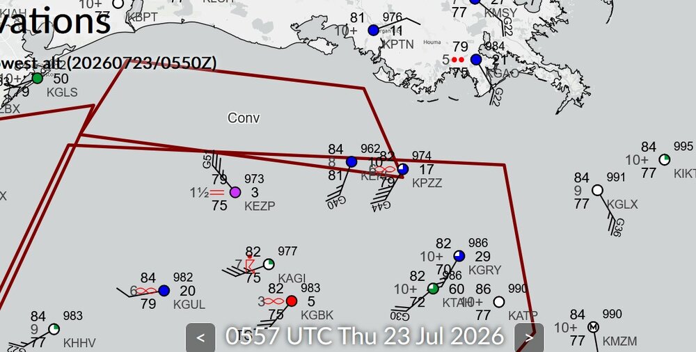
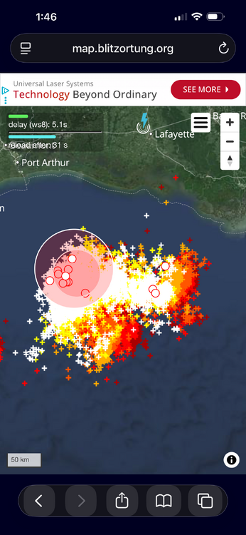
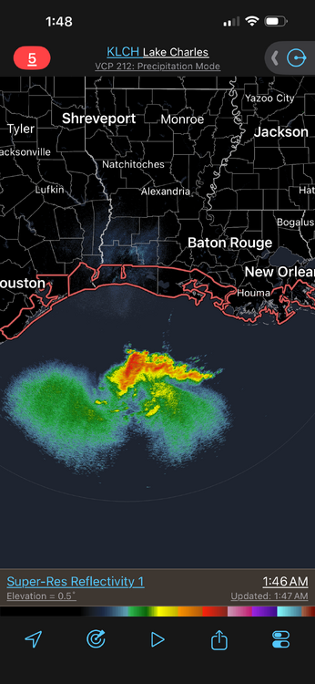
Now this is what I was talking about. Very intense convection b/c of the shear present. Cloud tops as cold as -90 C and an exceptional amount of CGs. Very dense. I attached a zoomed up image of the CG plot and it is still very dense! The strong shear in a tropical environment is promoting this intense convection. Looking at radar and then the EIR, you can see how these huge cold cloud tops are largely thick anvil w/ much small precip areas under it. Basically like a MCC or a supercell complex! Platforms in the Gulf are showing something going on as to a center much farther S and some mesoscale phenomena. KEZP earlier had sustained winds of 65G71KT at a height of 75 ft. This is transitory in squalls (svr tstms basically!). Here are some platform obs from near the possible new center. METAR KEKE 230535Z AUTO 20024G40KT 8SM BKN010 BKN014 OVC028 29/27 A2962 RMK A01 METAR KEKE 230515Z AUTO 22009KT 10SM SCT011 BKN016 OVC027 29/27 A2960 RMK A01 METAR KEKE 230455Z AUTO 18006KT 7SM SCT011 BKN016 OVC023 28/26 A2961 RMK A01 METAR KEKE 230435Z AUTO 36007G12KT 3SM HZ SCT014 BKN022 OVC043 28/26 A2960 RMK A01 METAR KEKE 230415Z AUTO 31018G24KT 10SM SCT011 BKN017 OVC043 29/27 A2959 RMK A01 METAR KEKE 230355Z AUTO 31025KT 1 3/4SM BR BKN011 BKN020 OVC027 29/27 A2958 RMK A01 VIS 3/4V5 METAR KEKE 230335Z AUTO 32024KT 10SM SCT016 BKN026 OVC065 29/27 A2959 RMK A01 METAR KEKE 230315Z AUTO 32033KT 10SM SCT013 BKN019 OVC060 29/26 A2956 RMK A01 METAR KEZP 230535Z AUTO 32035G51KT 1 1/2SM BR BKN003 OVC030 26/24 A2973 RMK A01 METAR KEZP 230510Z AUTO 27033G41KT M1/4SM FG OVC003 26/24 A2972 RMK A01 METAR KEZP 230455Z AUTO 23042G55KT M1/4SM FG OVC003 26/25 A2977 RMK A01 METAR KEZP 230435Z AUTO 21065G71KT M1/4SM FG OVC003 27/25 A2965 RMK A01 METAR KEZP 230415Z AUTO 25040KT 2SM HZ OVC036 29/25 A2972 RMK A01 METAR KEZP 230355Z AUTO 29034G42KT 5SM HZ BKN039 OVC045 29/25 A2968 RMK A01 METAR KEZP 230335Z AUTO 30042KT 7SM BKN043 BKN055 OVC070 30/25 A2966 RMK A01 METAR KEZP 230315Z AUTO 30041KT 8SM BKN046 BKN060 OVC120 30/25 A2967 RMK A01

-
Okay, I negged this front and its radar echoes earlier today in mid/long range thread and it has clearly told me to shove it. 2.5 inches and counting with a training line still going back 75 miles. Drought. Busting. .
-
.thumb.jpg.6a4895b2a43f87359e4e7d04a6fa0d14.jpg)
Central PA Summer 2026 Discussion/Obs Thread
Yardstickgozinya replied to Voyager's topic in Upstate New York/Pennsylvania
Spc mentions severe weather, returning to our area in the day 7 time frame. -
Bertha might look the best I’ve seen her yet! Maybe a center reformation nearer the convection?
-
 In Dorset, VT until Sunday. 55F compared to 70F back home. Got to imagine we get into the 40s tonight. Crazy for July
 -
Bertha seems to be growing this evening and radar kind of wants me to believe a new center is forming well off the coast. Maybe just a small spin or something.. but looks interesting nonetheless
-
-
More rain, fortunately training just south if me. Flash flood warning for southern parts of Easton.
-
Low of 81, high of 93. No rain.
-
You'll take your chances. You'll get up the next morning and have to tunnel out your window because of all the snow! That's what we mean by getting JanuBuried lol
-
It actually happened in 2013: 2013-08-01 74 68 71.0 -7.4 0 6 1.33 0.0 0 2013-08-02 86 68 77.0 -1.3 0 12 0.00 0.0 0 2013-08-03 79 68 73.5 -4.8 0 9 T 0.0 0 2013-08-04 80 66 73.0 -5.2 0 8 0.00 0.0 0 2013-08-05 78 62 70.0 -8.1 0 5 0.00 0.0 0 2013-08-06 78 63 70.5 -7.5 0 6 T 0.0 0 2013-08-07 76 68 72.0 -5.9 0 7 0.06 0.0 0 2013-08-08 87 71 79.0 1.2 0 14 0.35 0.0 0 2013-08-09 88 76 82.0 4.2 0 17 T 0.0 0 2013-08-10 84 73 78.5 0.8 0 14 0.00 0.0 0 2013-08-11 85 66 75.5 -2.1 0 11 0.00 0.0 0 2013-08-12 86 72 79.0 1.5 0 14 0.00 0.0 0 2013-08-13 83 68 75.5 -1.9 0 11 2.02 0.0 0 2013-08-14 76 63 69.5 -7.8 0 5 0.00 0.0 0 2013-08-15 78 58 68.0 -9.1 0 3 0.00 0.0 0 2013-08-16 81 60 70.5 -6.5 0 6 0.00 0.0 0 2013-08-17 82 63 72.5 -4.4 0 8 0.00 0.0 0 2013-08-18 77 66 71.5 -5.3 0 7 0.03 0.0 0 2013-08-19 77 65 71.0 -5.7 0 6 0.00 0.0 0 2013-08-20 87 66 76.5 0.0 0 12 0.00 0.0 0 2013-08-21 89 70 79.5 3.1 0 15 0.00 0.0 0 2013-08-22 85 70 77.5 1.3 0 13 1.08 0.0 0 2013-08-23 77 68 72.5 -3.6 0 8 T 0.0 0 2013-08-24 82 65 73.5 -2.4 0 9 0.00 0.0 0 2013-08-25 81 61 71.0 -4.8 0 6 0.00 0.0 0 2013-08-26 86 65 75.5 -0.1 0 11 T 0.0 0 2013-08-27 89 73 81.0 5.6 0 16 0.00 0.0 0 2013-08-28 76 72 74.0 -1.2 0 9 1.04 0.0 0 2013-08-29 83 71 77.0 2.0 0 12 T 0.0 0 2013-08-30 83 69 76.0 1.2 0 11 T 0.0 0 2013-08-31 88 72 80.0 5.4 0 15 0.00 0.0 0
-
 The woods are getting that late summer nighttime sound. A low buzz that eventually builds into a cacophony another 30 days from now. 67/54
 -
This is more or less what I have. It will run the roons and basics of the house, including continuous appliances (heat pumps, water heater, 2 fridges). You can run one temporary big appliance on top of that, like a dryer or microwave, just not multiple. Have lost power in the middle of the night in winter and didn't even think about rushing to set it up in the dark and weather. Keep the fridge shut, and get the generator going in the daylight. You shouldn't (can't?) run them in the rain, so if you go this route, given how often you lose power I'd recommend building a little housing unit for it. Keep it dry and in place for when you need it. I think @dryslot built himself a nifty little shack iirc.
-
2009 - 2010 was unbelievable. I never saw so much snow in Dale City back when I lived there, and I got to go to Charles Town back in 2009-10 and I got to see SO DAMN MUCH SNOW IT WAS RIDICULOUS! I was taking so many pictures of it with my phone! I was also 'stealing other people's snow' at 3am over there, jebwalking in drifts literally over my head and wallowing around like a true blue snow weenie! This obsessive walking is one reason why I am so crippled today, I can barely walk anymore.
-
Houston is getting storms originating from Bertha's circulation. Maybe this bodes better for Buda in a few days! Those organized storms are only 130 miles East-southeast from Buda!!!!!! I want my flooding rains BAD, far BADDER then Michael Jackson!! I crave to see that water level rise so bad!
-
 Blocky look, but with that complexity we are still far away from any confidence in what that will actually look like in the second half of the week. Higher than normal probs of bad weather I guess
 -
Hey meteorologists on here, I would like to politely request that EWX consider going ahead and hoisting an Extreme Heat Warning for North Hays County in Texas just for July 23, tomorrow. Highs will top out 100 degrees and dewpoints may well be in the lower to middle 70s. Today, July 22, we topped out at 102 degrees and it turned out that our dewpoint was 76. This means that locally here in Buda at the height of the heat this afternoon it felt like at least 119 degrees, perhaps the very low end of the 120s. This is serious heat even down here and we have hundreds of construction workers at it all day in Buda and Kyle, especially seeing that our region is now developing faster than places like Dubai in the UAE. The tech boom will be centered in Austin Texas and soon this region will have millions more people, especially as we really ramp up the Optimus iterations 3 - 5 General AI and Super AI robots in 2 years. Just a request. If there is an Extreme Heat package in place sometimes they will let those workers off earlier. (Maybe).
-
Bring it east
-
Wondering how many more 90 degree days we see… doesn’t look like any for the rest of the month. A 90 degree free August… wondering if Philly has ever had one… I’m sure they have, but not recently.
-
You guys have a "dirty ridge" with lots of storms in Colorado tonight.
-
Elias needs to go. End of.
-
Some great training out there where you are. Enjoy it
-
With the strong and strengthening El Niño, the odds are probably against a return to 100s.
-
 Feels like another late summer night Breezy and 63/53