All Activity
- Past hour
-

September 2025 OBS-Discussion centered NYC subforum
steve392 replied to wdrag's topic in New York City Metro
Fine with me. I'm missing the 40s and a cool drive to work already at 6am -
It is? Tonight Clear, with a low around 41. North wind 5 to 9 mph becoming light after midnight. Saturday Sunny, with a high near 66. Light and variable wind. Saturday Night Mostly clear, with a low around 39. Calm wind. Sunday Mostly sunny, with a high near 69. Calm wind becoming southeast 5 to 7 mph in the afternoon. Sunday Night Partly cloudy, with a low around 42. Light southeast wind. Monday Mostly sunny, with a high near 72. Calm wind becoming south 5 to 8 mph in the afternoon. Monday Night Partly cloudy, with a low around 53. Southwest wind around 5 mph. Tuesday A chance of showers after 1pm. Partly sunny, with a high near 77. Southwest wind 5 to 8 mph. Chance of precipitation is 40%. Tuesday Night A chance of showers. Mostly cloudy, with a low around 56. Southwest wind around 5 mph becoming calm in the evening. Chance of precipitation is 50%. Wednesday A chance of showers. Partly sunny, with a high near 69. North wind 3 to 8 mph. Chance of precipitation is 30%. Wednesday Night A chance of showers. Mostly cloudy, with a low around 49. North wind 3 to 5 mph. Chance of precipitation is 30%. Thursday A chance of showers. Partly sunny, with a high near 69. North wind 5 to 7 mph. Chance of precipitation is 30%. Thursday Night Partly cloudy, with a low around 47. Light northwest wind. Friday Mostly sunny, with a high near 71. Light and variable wind becoming west around 6 mph in the morning.
-

2025-2026 ENSO
PhiEaglesfan712 replied to 40/70 Benchmark's topic in Weather Forecasting and Discussion


-
Yeah it’s going to take a little time but this might very well take off once it has sufficiently organized. Could be some open ocean eye candy.
-
Impressive 94 at 4pm. Definitely a late summer 94, humidity was 34%.
-
Wet day in the Twin Cities. After a dry stretch this is welcome moisture as the Butternut Squash in my garden gets ready to be harvested.
-
Torch!
-
It was warm today in W MA.
-

September 2025 OBS-Discussion centered NYC subforum
donsutherland1 replied to wdrag's topic in New York City Metro
Probably. However, one can't completely rule out a later such temperature, even as it doesn't show up on any of the guidance right now. Just over 1-in-6 years in JFK's period of record saw 86° or above temperatures on September 20th or later. The most recent was 2019 with the epic 95° high on October 2. The last week of the month has some potential with the forecast drop in the PNA, though an even sharper drop would increase prospects. -
This is it for weeks.
-
Not far lol. By ABE
-

September 2025 OBS-Discussion centered NYC subforum
LibertyBell replied to wdrag's topic in New York City Metro
thats too cold, 25C is okay I dont want to start my heating until November -

2025 Atlantic Hurricane Season
Maestrobjwa replied to BarryStantonGBP's topic in Tropical Headquarters
I think you meand to post this in the other thread -

E PA/NJ/DE Autumn 2025 Obs/Discussion
Birds~69 replied to PhiEaglesfan712's topic in Philadelphia Region
Yellow leaves here and the winds picked up so they are falling at a good rate. And what the hell are you doing in a Walmart parking lot observing leaves falling? I may join you with a couple cold ones...
-
Wet stretch coming Sunday Euro 12z: GFS 12z: To add insult to injury however, models are in agreement on a large cutoff low coming by the middle of next week that is expected to be around through the end of the month. 12z Euro: 12z GFS:
-
High of 86 here. Too warm. Thankfully its just a one day thing.
-
90F at DCA today
-

September 2025 OBS-Discussion centered NYC subforum
Sundog replied to wdrag's topic in New York City Metro
I don't want to see anything above 20C until next April -
It's worth $20, I always stopped at Millies food truck on the way out to take some good polish food home.
-
This is encouraging.
-
Oh I'd really want to see those fireflies and great views. Where are those caves you told me about with stone age neolithic tools? I remember you mentioned them a year or two ago.
-
September 2025 OBS-Discussion centered NYC subforum
LibertyBell replied to wdrag's topic in New York City Metro
Nice to see JFK equal EWR, this is what I call true heat. -
September 2025 OBS-Discussion centered NYC subforum
LibertyBell replied to wdrag's topic in New York City Metro
30C !!! The highest temperature for the rest of the year, Don ??? -

September 2025 OBS-Discussion centered NYC subforum
psv88 replied to wdrag's topic in New York City Metro
85 today, same as Islip - Today
-
September 2025 OBS-Discussion centered NYC subforum
donsutherland1 replied to wdrag's topic in New York City Metro
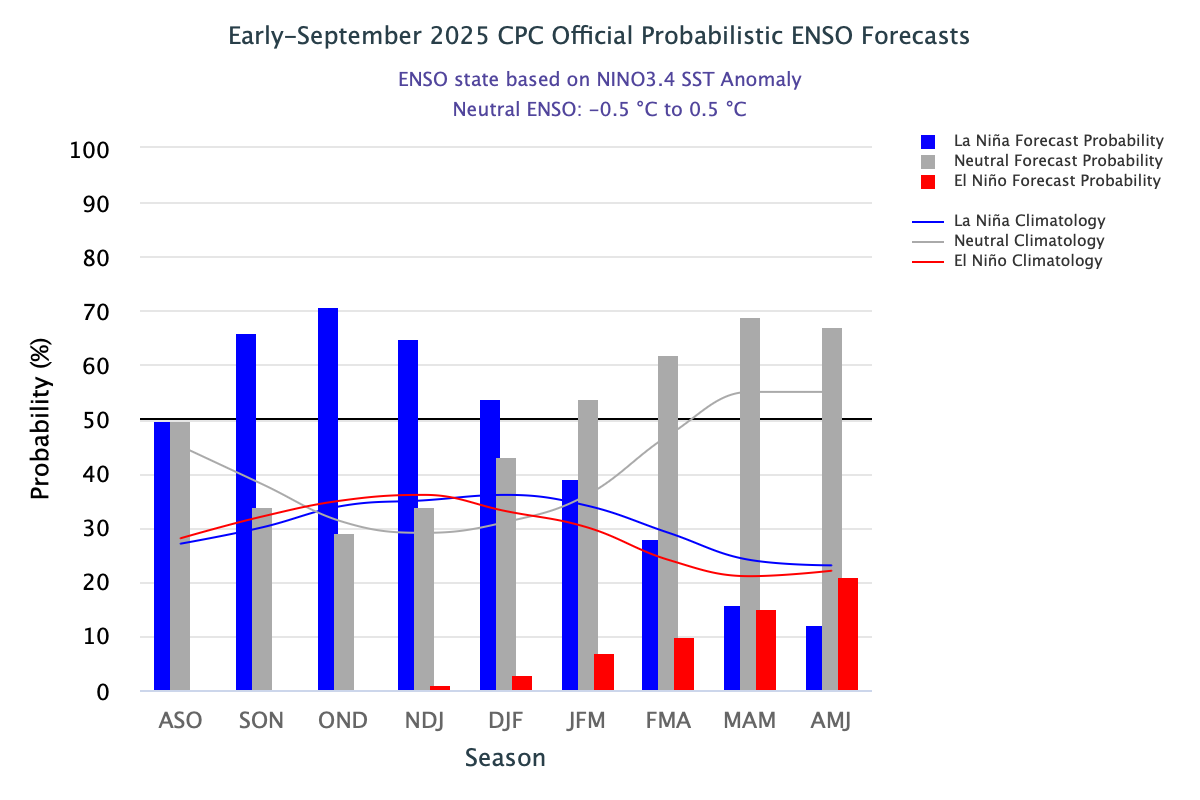
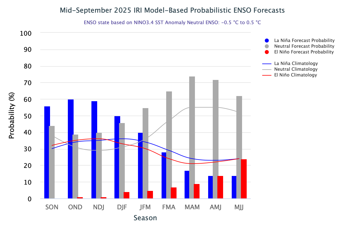
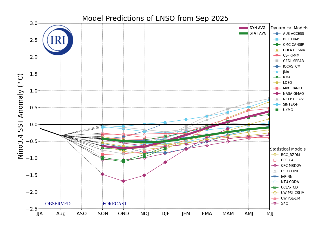
Today was an unseasonably warm late September day. Preliminary highs included: Bridgeport: 84° Islip: 85° (tied record from 1983) New Haven: 84° New York Cty-Central Park: 84° New York City-JFK Airport: 86° New York City-LaGuardia Airport: 83° Newark: 86° Philadelphia: 84° Westhampton: 83° (tied record set in 1967 and tied in 2024) White Plains: 82° Cooler air will return overnight for the weekend. Temperatures will top out mainly in the lower 70s tomorrow through Monday. It will then turn warmer on Tuesday before another cool front crosses the region on Wednesday. The advancing front could trigger some showers or thundershowers. The ENSO Region 1+2 anomaly was -0.2°C and the Region 3.4 anomaly was -0.5°C for the week centered around September 10. For the past six weeks, the ENSO Region 1+2 anomaly has averaged +0.10°C and the ENSO Region 3.4 anomaly has averaged -0.37°C. La Niña conditions will likely develop during mid- or late-autumn. The SOI was -4.34 today. The preliminary Arctic Oscillation (AO) was -0.972 today. Based on sensitivity analysis applied to the latest guidance, there is an implied near 57% probability that New York City will have a cooler than normal September (1991-2020 normal). September will likely finish with a mean temperature near 69.0° (0.2° below normal). Supplemental Information: The projected mean would be 1.0° above the 1981-2010 normal monthly value.


.thumb.png.4150b06c63a21f61052e47a612bf1818.png)


