All Activity
- Past hour
-
I obviously think the probability is low for a high end snow, but I’m still keeping my eye on that period. It’ll be the last one for this area until next season. It’s intriguing to say the least.
-
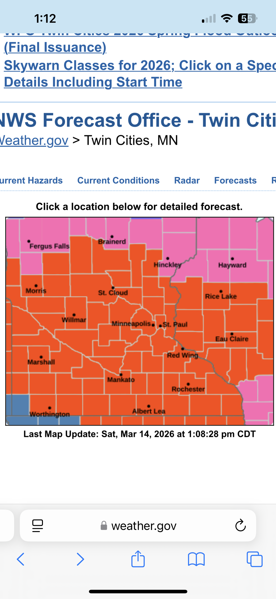
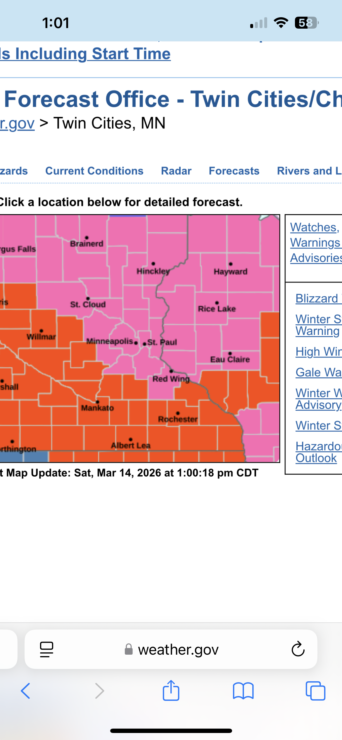
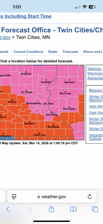
There it is. The entire MPX CWA is under a blizzard warning. That might be a first. .

-
That’s not true. This subforum is amazing at wind, heat, CAD, and failure
-
The Chill WDI remains favorable.
-

Central PA Spring 2026 Discussion/Obs Thread
canderson replied to Voyager's topic in Upstate New York/Pennsylvania
NAM has an incredibly nasty QLCS rush hour ish Monday. It’d cause significant issues. -
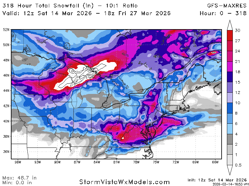
300+ hour snowmap on the op GFS at the end of March. That deserves a double bun!! lmfaoooooo
-
Was mentioning that last night to my colleague on the winter desk. Basically anything north of GB up into the U.P is going get clocked. I’d love to post up in Iron Mountain, MI right on the WI/MI border. Should see 2-3’ there. Marquette area and the Huron Mtns will probably see 3-5’ with the storm and additional LES. Insane storm for up there
-
I did post an h5 map for that window a couple days ago- I said it was awfully late outside of the mountains, but ya never know. Shit can happen the last week of March, and this might be the winter for it given we have scored multiple times without the 'ideal' upper level pattern.
-
Probably gone by Tuesday but some yards still have legit 12 to 16 in them then others bare
-
December (2024) and February (2025) were near normal. January being well below average made the winter BN. This December, January, and February were all well below average. The first time since January, February, and March 2015. Of course, that was followed by a near record warm May.
-
I thought dragons lives there?
-
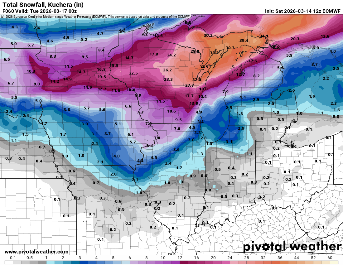
Euro continues to be super wet for Monday
-
Gotta imagine we have a blizzard warning incoming here in MSP .
-

Spring 2026 Pattern Discussion Thread
Carvers Gap replied to Carvers Gap's topic in Tennessee Valley
Oh man - I just saw this. I hate to hear that. We will be praying for you and your family. -

Central PA Spring 2026 Discussion/Obs Thread
Blizzard of 93 replied to Voyager's topic in Upstate New York/Pennsylvania
The way this Winter has gone, you never know… I just have a feeling that we get one last ride… -
Make it 5x now.
-
The snow will accumulate if the pattern is right.
-
Euro has nothing but the potential is there.
-

E PA/NJ/DE Spring 2026 Obs/Discussion
LVblizzard replied to PhiEaglesfan712's topic in Philadelphia Region
Ya know what, if it’s gonna be cold, give us more snow. Cold and dry this time of year is brutal. Snow at least makes it a little more interesting. Plus the cleanup doesn’t take as long with the sun angle helping melt the snow very quickly this time of year. -
Def going to end up with Wind Advisory followed by Winter Weather Advisory. Might sneak in a Severe Thunderstorm Warning in between.
-

E PA/NJ/DE Spring 2026 Obs/Discussion
RedSky replied to PhiEaglesfan712's topic in Philadelphia Region
This is the most atmospheric memory pattern ever when does it stop This is what 4 SSWE can do -
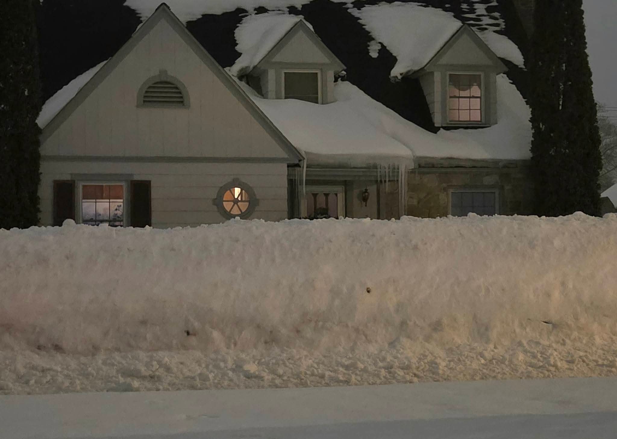
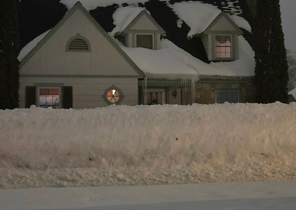
I head there for a 3-4 day trip every mid to late feb. This year we had a good cold, white winter here in southern MI, but once deep winters back gets broken in southern MI, northern MI hits peak. Their deepest snow is usually mid Feb to mid Mar. Its incredible. I seriously thought about heading up for the storm but its extra cash I shouldn't spend and I risk getting stuck in the UP for an unknown amt of time with Mackinac Bridge closures. For reference. The area thats expecting 12-36" of snow over a 48 hour period....thats on top of a massive snowpack. This pic was from Feb 18.
-
The 12z Euro bumped up the defo zone and is the most robust of the models.

-
Me too. I’m in hillbilly country
-
Thinking 10” here as a first call. Maybe 0.5” overnight that melts into tomorrow. Front comes through late afternoon and then we start ripping.