All Activity
- Past hour
-
Severe thunderstorms in Culpepper.
-
Someone turn this rain off. I don't need any more at this juncture. I get about less then a quarter inch and it is sitting on top of the ground in my low lands. Since Friday I have received .87 and it is now 6:05 pm this Sunday. My garden is in the lowland and I had the tiller in there this morning before it rained again. The ground is extremely wet. And a few places ther was mud on the rototiller tires.
-
I swear I see some rotation on that one using the velocity scan.
-
I’ve been busy this week and was surprised to see Blewett pitching for the Os again. Sad and disappointed.
-
Was out in the burbs for a bday, lost power at a brewery for a bit, nice garden variety
-
I saw this and panicked a little, as a lot of my family is in Oklahoma still but thankfully not the SW part of the state. I still follow a meteorologist from the state on FB and yesterday he posted the worst stuff should be to the south so this tracks. Looks like the tornado warning in the NW corner of the TX panhandle is an active tornado. Seeing lots of active tornadoes in these storms this year.
-
Just light on/off showers 0.12”
-
Yes. Warm fronts are devious.
-
0.45 on the day so far
-
That would be amazing!
-
.thumb.png.4150b06c63a21f61052e47a612bf1818.png)
2025 Lawns & Gardens Thread. Making Lawns Great Again
HIPPYVALLEY replied to Damage In Tolland's topic in New England
Is there a reason why my neighbor would be mowing his lawn every 2 to 3 days? He’s only 60 and retired so it could just boredom but maybe there is a good reason for mowing that frequently? i’m not going to ask him because I find it all a little annoying and he’ll probably detect that in my voice. edit: this is the same person, who will spend Sunny days in late February and early March, snowblowing snow from shady sections of the yard into sunny sections to melt it quicker. -
Yeah this is brutal. Little Rock was even worse July '22. I think Arkansas is the worst overlay of actual air temp with humidity in the country.
-
That cell in Culpepper looks juicy
-

June 8 Southern Plains Severe Outbreak
Powerball replied to Powerball's topic in Central/Western States
The showers moving east out of Jack County bear watching. They could potentially intensify to severe t'storms like the cells in Palo Pinto County, which would pose a problem for DFW. -

June 8 Southern Plains Severe Outbreak
Chinook replied to Powerball's topic in Central/Western States
This nearly maxes out reflectivity, tornado warning at this time -
June 8 Southern Plains Severe Outbreak
Powerball replied to Powerball's topic in Central/Western States
Severe Thunderstorm Warning TXC363-082230- /O.NEW.KFWD.SV.W.0371.250608T2121Z-250608T2230Z/ BULLETIN - IMMEDIATE BROADCAST REQUESTED Severe Thunderstorm Warning National Weather Service Fort Worth TX 421 PM CDT Sun Jun 8 2025 The National Weather Service in Fort Worth has issued a * Severe Thunderstorm Warning for... Central Palo Pinto County in north central Texas... * Until 530 PM CDT. * At 421 PM CDT, a severe thunderstorm was located 9 miles south of Possum Kingdom Lake, or 22 miles northeast of Ranger, moving east at 20 mph. HAZARD...60 mph wind gusts and half dollar size hail. SOURCE...Radar indicated. IMPACT...Hail damage to vehicles is expected. Expect wind damage to roofs, siding, and trees. * This severe thunderstorm will be near... Lake Palo Pinto around 445 PM CDT. Other locations impacted by this severe thunderstorm include Brazos, Lone Camp, Santo, and New Salem. This includes Interstate 20 between mile markers 378 and 389. PRECAUTIONARY/PREPAREDNESS ACTIONS... For your protection get inside a sturdy structure and stay away from windows. && LAT...LON 3279 9806 3251 9807 3251 9809 3267 9857 3286 9858 TIME...MOT...LOC 2121Z 287DEG 16KT 3274 9846 HAIL THREAT...RADAR INDICATED MAX HAIL SIZE...1.25 IN WIND THREAT...RADAR INDICATED MAX WIND GUST...60 MPH $$ Stalley -
Kind of a sneaky dewy day. 62-64 all day here. Spent entire day in yard , pruning all bushes , lawn . Lots of sun this afternoon. Crushed and I mean crushed by mosquitoes especially this morning in the shade and later in the day .
-
June 8 Southern Plains Severe Outbreak
Powerball replied to Powerball's topic in Central/Western States
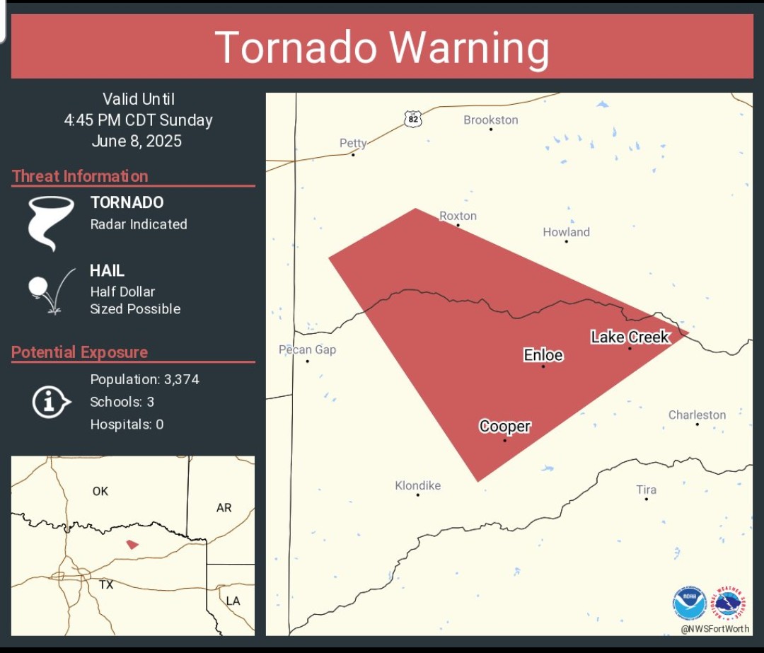
Tornado Warning TXC119-277-082145- /O.NEW.KFWD.TO.W.0047.250608T2111Z-250608T2145Z/ BULLETIN - EAS ACTIVATION REQUESTED Tornado Warning National Weather Service Fort Worth TX 411 PM CDT Sun Jun 8 2025 The National Weather Service in Fort Worth has issued a * Tornado Warning for... Northwestern Delta County in north central Texas... Southwestern Lamar County in north central Texas... * Until 445 PM CDT. * At 410 PM CDT, a severe thunderstorm capable of producing a tornado was located near Roxton, or 16 miles southwest of Paris, moving southeast at 15 mph. HAZARD...Tornado and half dollar size hail. SOURCE...Radar indicated rotation. IMPACT...Flying debris will be dangerous to those caught without shelter. Mobile homes will be damaged or destroyed. Damage to roofs, windows, and vehicles will occur. Tree damage is likely. * This dangerous storm will be near... Big Creek Lake around 420 PM CDT. Cooper around 425 PM CDT. Other locations impacted by this tornadic thunderstorm include Gadston and Ben Franklin. PRECAUTIONARY/PREPAREDNESS ACTIONS... TAKE COVER NOW! Move to an interior room on the lowest floor of a sturdy building. Avoid windows. If you are outdoors, in a mobile home, or in a vehicle, move to the closest substantial shelter and protect yourself from flying debris. && LAT...LON 3352 9583 3356 9576 3346 9554 3334 9571 TIME...MOT...LOC 2110Z 321DEG 13KT 3349 9574 TORNADO...RADAR INDICATED MAX HAIL SIZE...1.25 IN $$ Stalley
-
It's over. Winter cancel!
-
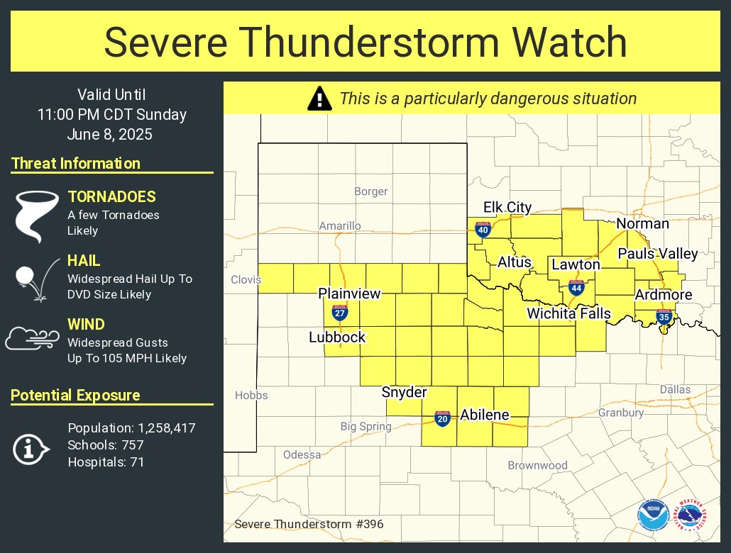
Not sure I've ever seen a watch for winds up to 105 MPH *AND* 5" diameter hail before... https://www.spc.noaa.gov/products/watch/ww0396.html
-
June 8 Southern Plains Severe Outbreak
Powerball replied to Powerball's topic in Central/Western States
URGENT - IMMEDIATE BROADCAST REQUESTED Severe Thunderstorm Watch Number 396 NWS Storm Prediction Center Norman OK 400 PM CDT Sun Jun 8 2025 The NWS Storm Prediction Center has issued a * Severe Thunderstorm Watch for portions of Southwest Oklahoma Western North Texas and Low Rolling Plains * Effective this Sunday afternoon and evening from 400 PM until 1100 PM CDT. ...THIS IS A PARTICULARLY DANGEROUS SITUATION... * Primary threats include... Widespread damaging winds and scattered significant gusts to 105 mph likely Widespread large hail likely with isolated very large hail events to 5 inches in diameter possible A few tornadoes likely SUMMARY...Increasing intense severe storm development is expected through late afternoon into evening. This will include initial supercells capable of very large hail with a tornado risk, but a prominent potential for widespread damaging winds should evolve this evening.
-
You know...I heard someone joke once (maybe it was a comedian?) that we should live our lives in reverse. Start out dealing with death, then go through any pains of old age (get off my lawn!), then have a regular job with a good salary, then party it up in college, deal with high school, then be a kid again without any real worries, be a toddler not having much knowledge of anything, and finally...end your life as an orgasm!
-
Steady rain the last 2 hours here
- Today
-
Yummy mummies and mist. Doesn't sound that bad.
-
Flash flood warning west of DC. Hopefully that juices up and gives the area a soaker this evening.