All Activity
- Past hour
-
 Yes, very nice here. It is 80 with a dew of 61 and winds 5-15 mph. Had to put balance out some pool chemicals for a small party here on Saturday.
 -

2025-2026 ENSO
michsnowfreak replied to 40/70 Benchmark's topic in Weather Forecasting and Discussion
I heard it was the coldest summer in parts of coastal California in over 50 years. Didn't look up any numbers tho -
 Working from home this week and taking a lunch break outside. It’s rather pleasant out. Slight tick up in humidity but very comfortable with a light ENE breeze.
 -
Looks beautiful for my OBX week now. Hopefully the cat 5 up the Bay hold off until a few days after I get home so I can get my insurance squared away.
-
81 at noon
-
2025-2026 ENSO
michsnowfreak replied to 40/70 Benchmark's topic in Weather Forecasting and Discussion
Many la ninas have historically had great Decembers (at least here). But results are then mixed as to whether or not it carried thru to the rest of winter. -
Hopefully we can experience a “Smoky” hurricane in a few weeks
-
We blue sky we COC now
-
Nothing beats the holidays in 2015 70s for a week
-
You'll know it's October when we have out annual fall heat ridge and you're carving pumpkins in 90 °F heat.
-
I’m not sure, but just last year we had two majors hit Florida in ~10 days of each other.
-

2025 Lawns & Gardens Thread. Making Lawns Great Again
Damage In Tolland replied to Damage In Tolland's topic in New England
Banner year for them here. I must have 50 or more that have either been picked or growing off of just 3 plants. On the ground https://imgur.com/a/xleJVfO -

2025-2026 ENSO
donsutherland1 replied to 40/70 Benchmark's topic in Weather Forecasting and Discussion
August has grown hotter and drier in Phoenix. It is also warmer than July was in the past. That includes extreme heat. August 2020-2025 has had more high temperatures of 115 or above than the entire August 1895-2019 period. This year’s monsoon season is also off to a dismal start in the Phoenix area.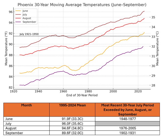
-
i also have a rock that keeps panthers away
-
 Yeah, locations that didn’t have the flooding have been very dry this summer. My area just east of HVN has had the 11th driest June 1st through August 6th. Most of the grassy areas are brown around here. It has also been the 2nd warmest summer over the same period. Very uneven rainfall patterns across the area during recent years. Last few years have been an all or nothing type of rainfall patterns. Where we alternate between drought and flash flooding. Light rains don’t do much in such a warm climate since the warmth quickly dries things out after the light rains. A cooler summer can do OK with less rainfall. Time Series Summary for NEW HAVEN TWEED AP, CT Driest June 1st through August 8th Click column heading to sort ascending, click again to sort descending. 1 2000-08-06 1.80 60 2 1957-08-06 2.70 0 3 2017-08-06 3.01 3 4 1966-08-06 3.16 0 5 2016-08-06 3.44 0 6 2014-08-06 3.46 1 7 1954-08-06 3.49 0 8 1976-08-06 3.76 0 9 1949-08-06 3.86 0 10 2022-08-06 3.88 0 11 2025-08-06 4.15 0 Time Series Summary for NEW HAVEN TWEED AP, CT Warmest June 1st through August 8th Click column heading to sort ascending, click again to sort descending. 1 2024-08-06 76.1 0 2 2025-08-06 75.1 0 3 1977-08-06 74.9 31 4 2022-08-06 74.5 0 - 2020-08-06 74.5 2 5 2010-08-06 74.4 0 6 2019-08-06 74.0 0 7 2013-08-06 73.9 0 8 2012-08-06 73.5 0 - 2008-08-06 73.5 0 9 2023-08-06 73.1 1 10 2011-08-06 72.9 0
 -
I wanna say ... 1999? there were a couple of obnoxious warm departures between Halloween and January 1 that late autumn/early winter. The SE ridge had become proxy over the flow east across the continent, and each time it lasted a week. I remember consecutive days in the upper 60s balm, with no leaves on the trees and sweating streets. One of them had a couple days to 74. Something like that, tho not as extreme took place in 2006, too.
-

Mountain West Discussion
mayjawintastawm replied to mayjawintastawm's topic in Central/Western States
We've been able to open windows and turn a big fan on most nights, but last night the temp went down to 68 at 11 PM but rose after that, 73 at 6 AM. Stuffy. One of many reasons I don't live in AZ. -
i'm gonna be in boston in two weeks. do any of you guys who approve of the noaa cuts want me to stop by? i have a great deal on volcano insurance
-
That's actually more Nina I thought - the SE ridge and Nina are lusty sweaty bed companions during winter... but heh.... CC will f* it all up too
-
Agree. There are obviously exceptions to every rule but in general he’s correct. -ENSO/-PDO winters that don’t do well in November and December are *usually* abysmal
-

TROPICAL WAVE LOCATED IN CHAD, AFRICA (NOT 96L)
GaWx replied to BarryStantonGBP's topic in Tropical Headquarters
W African AEW: 1. The 12Z ICON is slightly stronger than the 0Z with the W African AEW. At 180, it has what already looks like a TD (well organized 1008 mb low at 19N, 46W. Although a TC near that position often recurves safely, this one is turning back to just N of due W after moving WNW earlier due to a stronger high to its north at this longitude. 2. The 12Z UKMET doesn’t have this. However, the 0Z had this data, which may or may not be from the same AEW: NEW TROPICAL CYCLONE FORECAST TO DEVELOP AFTER 114 HOURS FORECAST POSITION AT T+114 : 15.4N 18.6W LEAD CENTRAL MAXIMUM WIND VERIFYING TIME TIME POSITION PRESSURE (MB) SPEED (KNOTS) -------------- ---- -------- ------------- ------------- 0000UTC 12.08.2025 120 15.6N 21.0W 1009 28 1200UTC 12.08.2025 132 15.0N 24.0W 1010 27 0000UTC 13.08.2025 144 15.4N 26.0W 1010 23 1200UTC 13.08.2025 156 CEASED TRACKING - Today
-
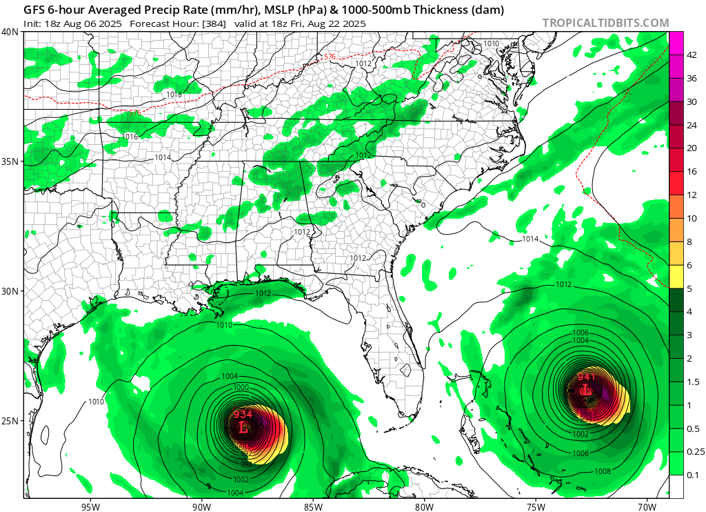
From yesterday. I know it's hr 384 but it got my brain going. Is there any historical precedent for what's shown, two sub 950mb canes approaching the SE simultaneously?

-
 I know we are way in advance here, but how’s the end of the month looking? preferably Labor Day weekend. I’ll be at the shore.
 -
 We've had almost no rain here since the flooding a few weeks ago. The ground is very dry and I'm having to water the vegetable garden often. Next week looks rough with very little chance of rain during the big heat wave. The grass will be burning out. I know Walt was talking about a potential flash drought a couple days ago. I hope we're not heading towards a drought like what happened last year at the end of the summer and the fall.