All Activity
- Past hour
-

January 25-26 Winter Storm Potential
MickeyTim6533 replied to Ralph Wiggum's topic in Philadelphia Region
geez, gfs at hour 228....wow -
I’ve decided to just pretend the GEFS knows WTF it’s doing

-
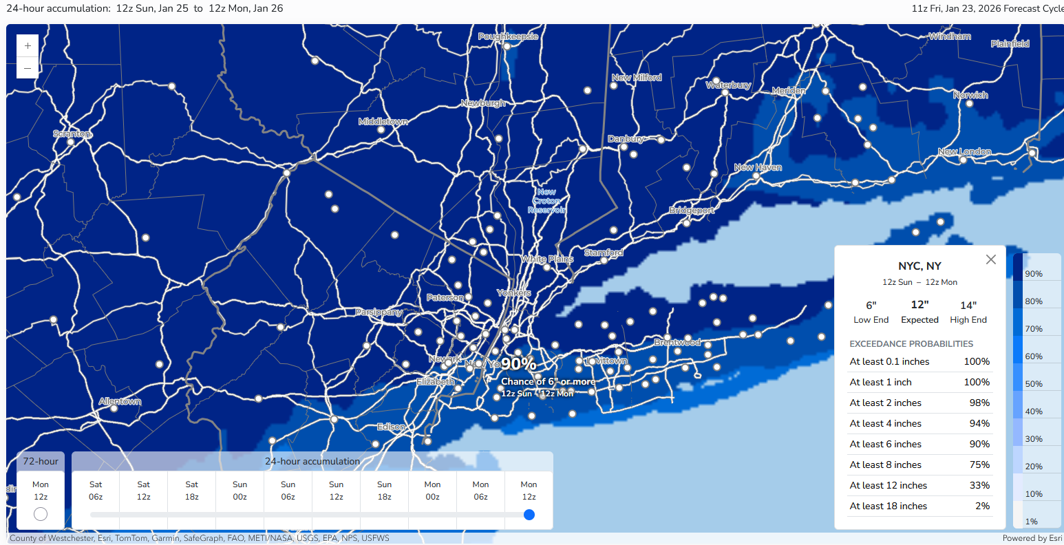
 Latest NWS probabilistic estimate of 6" or more snow for New York City: 90% Islip was at 81% and Newark was at 88%.
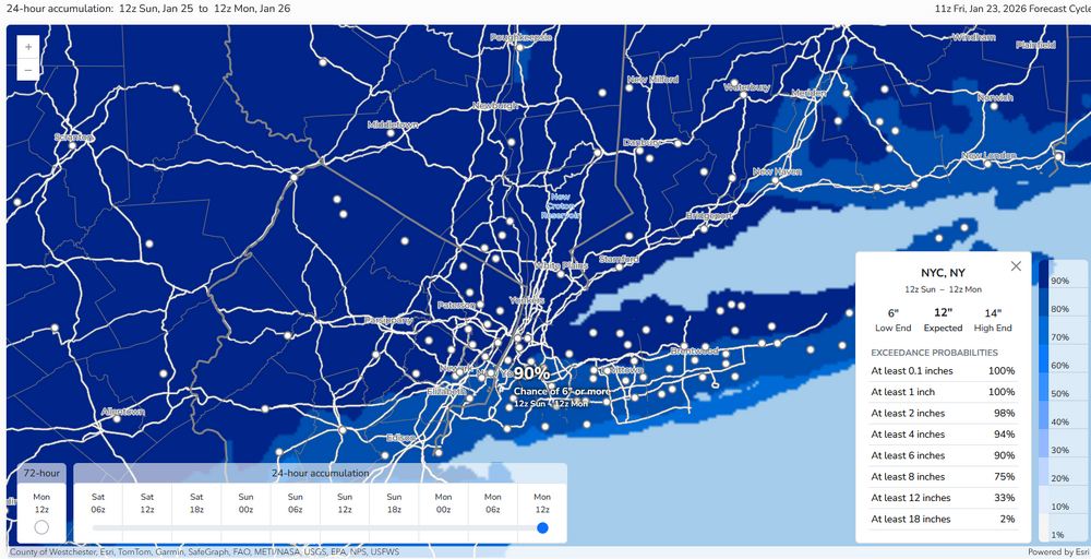
-

January 24-26: Miracle or Mirage JV/Banter Thread!
H2O replied to SnowenOutThere's topic in Mid Atlantic
Oh and lol to come back this morning to people fucking fighting over snow maps -
Btw….to anyone using the Beta site on Pivotal be careful when clicking soundings. When I’m in landscape mode the lat/long is correct, but when I flip the view to portrait it’s shifting my longitude off by a solid 1°.
-
January 24-26: Miracle or Mirage JV/Banter Thread!
H2O replied to SnowenOutThere's topic in Mid Atlantic
If it sleet bombs like the models show then I say fucking bring it. Gimme a ton of it. I’ll take sleet over ZR and plain rain all day, every day -
Central PA Winter 25/26 Discussion and Obs
MickeyTim6533 replied to MAG5035's topic in Upstate New York/Pennsylvania
geez, gfs at hour 228....wow -
Only 216hrs out, too. Lock it in.
-

“Cory’s in LA! Let’s MECS!” Jan. 24-26 Disco
Kitz Craver replied to TheSnowman's topic in New England
Not one CT met is calling for that, I guess it’s plausible though. We’ll see, but I doubt it makes it that far north -

Richmond Metro/Hampton Roads Area Discussion
jlewis1111 replied to RIC Airport's topic in Mid Atlantic
all models caving to the gfs for this weekend. Trending colder this should be interesting how all this turns out for the weekend -
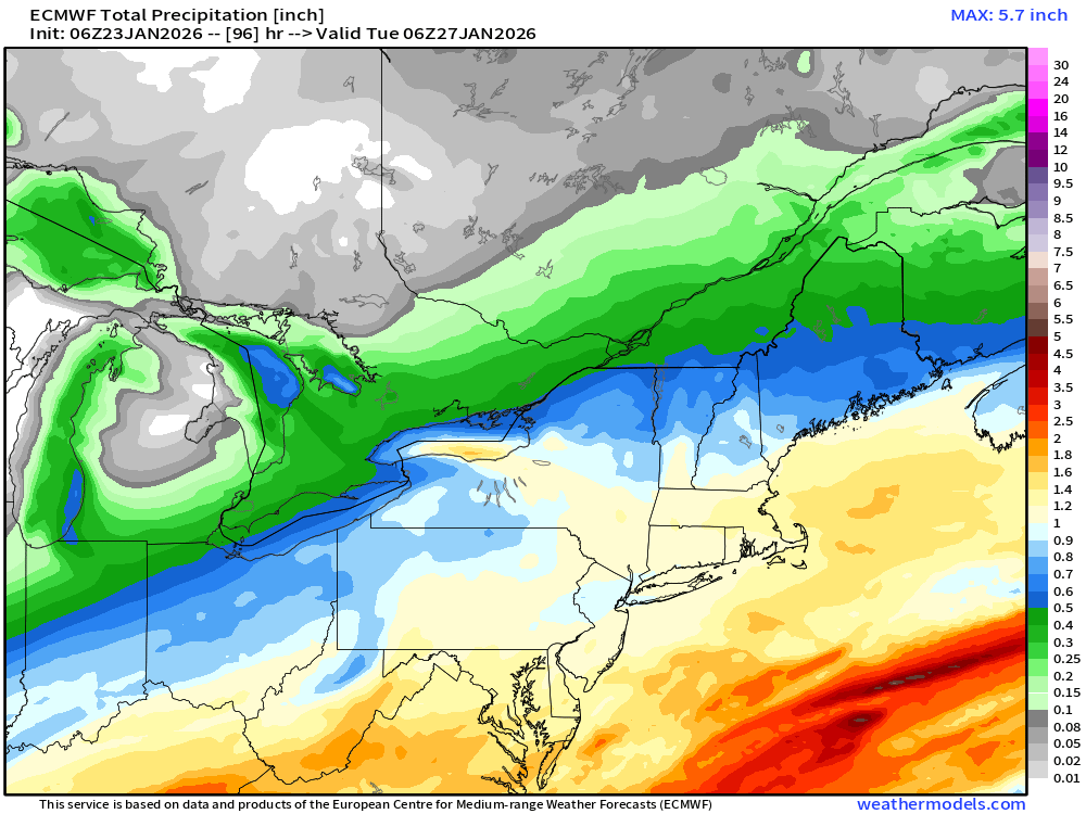
06z euro QPF for moneypitmike
-
I think that’s a good safe number. Soundings are pretty good here, but it’s tough to sustain huge ratios (20-25:1) with higher QPF. There’s a period on the euro where we’re saturated and in the DGZ from the sfc to H5.
-
I have no concerns to what the ICON has, But the GFS has been slowing ticking the qpf up for us, Also need to keep in mind, This is going to be some high ratio fluff so you can get more snow with less qpf.
-
Anyway, I hid all the back/forth over that map. Sorry to derail.
-
Im officially on the "i hope we end up roasting and rain out" bandwagon. Then idk I may be onto spring after that.
-
Ahhh sorry, no that’s my bad for misunderstanding. Less pingers for all!
-
Doubt we would see sleet up here with this airmass but i wouldn't rule it out further south, I know what the tendencies are in these.
-
About the pingers. Hope ya don’t change. Sorry for pulling for ya, I’ll go back to lurking…
-

“Cory’s in LA! Let’s MECS!” Jan. 24-26 Disco
RUNNAWAYICEBERG replied to TheSnowman's topic in New England
Why I think 10-14” is the max in swct. We’ll Be seeing the sleet line make ir’s way to the pike by tomorrow… -

Pittsburgh/Western PA WINTER ‘25/‘26
Gordo74 replied to Burghblizz's topic in Upstate New York/Pennsylvania
Pleasantly surprised by the overnight models. This thing looks, dare I say, locked in for the track? Westmoreland Co WSW has 12-17 inches in the notice and a glaze of ice possible. -
Uh thanks?
-
So every model has central valley with. 25 to. 50 ice but still no updated advisory.
-
Following the snowstorm this weekend I would like to see the ridge axis out West back off a little to allow coastal development closer in instead of further offshore like the EPS and EPS-AIFS into next weekend. Many times we get a snow event at the start of a pattern and at the end. So it looks like the snow potential will continue into at least early February with the exact storm dates to be determined later. I am happy that the long advertised more active STJ pattern came to pass as there is only so much snow we can get exclusively from Northern Stream disturbances here.
-
Euro got better up here, CMC is fairly steady, but icon took a big step towards the GFS which makes me nervous. I'm fine with 6-8 inches and would be thrilled, less than that and it'll be pretty depressing, haha.
-
I hope you’re wrong for your sake and right for mine. Good luck regardless!