All Activity
- Past hour
-

“Cory’s in NYC! Let’s HECS!” Feb. 22-24 Disco
Scott Koziara replied to TheSnowman's topic in New England
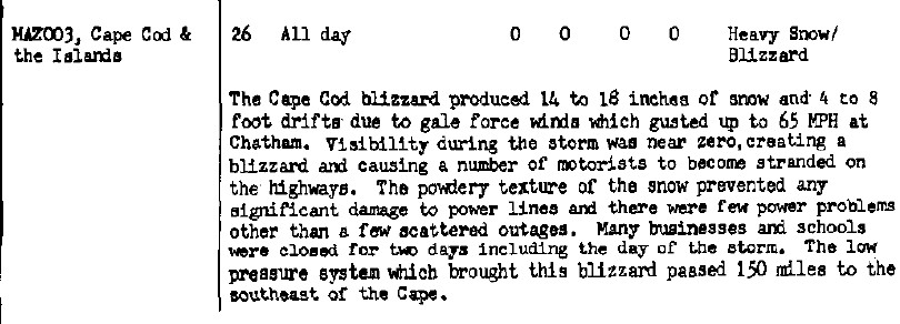
Thanks! Newport had about 8 inches in the January event and maybe 5 in the February event. The February event was a huge bust for anyone west and north of New Bedford with busted forecasts of a foot plus across the entire region. A bust but not as bad as the February 1989 bust. -
High if 36, down to 34 right now, the not hitting 40°F stretch continues worn 4 or 5 inches of solid snow cover still evident... going on nearly 30 days of not hitting 40 since jan 22nd.. Central Park had snow depth of over an inch end yesterday at 23 days, tired at 21st longest with longest ever being 56 days back 2/17/48
-
The Euro is a fantastic model but it’s not infallible and has been on an island / wrong before.
-
This weekend isn't far from trending to something at least light for the upper SE
-
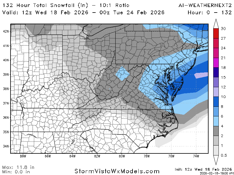
12Z AI Weathernext2 SV: DC 6” vs 8” on 6Z
-

Late February/Early March 2026 Mid-Long Range
winter_warlock replied to WxUSAF's topic in Mid Atlantic
Ji, ud never make it as a motivational speaker bro -
I’ve witnessed some good events in March. March 1, 1978, March 1, 1980, March 24, 1983 (record setter), March 13, 1993, March 1, 2009.
-
Nothing better than pollen month! uggg..lol
-
-
-

E PA/NJ/DE Winter 2025-26 Obs/Discussion
RedSky replied to LVblizzard's topic in Philadelphia Region
7" snowcone depth -

Wednesday Feb 18 Mixed event. NOPE …ain’t happenin’
CPcantmeasuresnow replied to HoarfrostHubb's topic in New England
Saratoga Springs NY 35 and nothing happening. WWA yesterday for 2-6. I haven't seen any of those 2-6 flakes yet. -
Recon flights might give a better answer in tomorrow runs NOUS42 KNHC 171825 REPRPD WEATHER RECONNAISSANCE FLIGHTS CARCAH, NATIONAL HURRICANE CENTER, MIAMI, FL. 0125 PM EST TUE 17 FEBRUARY 2026 SUBJECT: WINTER SEASON PLAN OF THE DAY (WSPOD) VALID 18/1100Z TO 19/1100Z FEBRUARY 2026 WSPOD NUMBER.....25-079 AMENDMENT I. ATLANTIC REQUIREMENTS 1. NEGATIVE RECONNAISSANCE REQUIREMENTS. 2. OUTLOOK FOR SUCCEEDING DAY.....NEGATIVE. II. PACIFIC REQUIREMENTS 1. FLIGHT ONE - TEAL 77 A. 18/1800Z, 19/0000Z B. AFXXX 33WSE IOP33 C. 18/1700Z D. 8 DROPS APPROXIMATELY 60 NM APART WITHIN AN AREA BOUNDED BY: 25.0N 150.0W, 40.0N 150.0W, 40.0N 125.0W, AND 25.0N 125.0W E. AS HIGH AS POSSIBLE/ 18/1430Z TO 19/0230Z 2. FLIGHT TWO - NOAA 49 A. 19/0000Z B. NOAA9 34WSE IOP33 C. 18/2000Z D. 30 DROPS APPROXIMATELY 60 NM APART WITHIN AN AREA BOUNDED BY: 35.0N 125.0W, 35.0N 150.0W, 48.0N 150.0W, AND 48.0N 125.0W E. 41,000 TO 45,000 FT/ 18/2030Z TO 19/0230Z 3. SUCCEEDING DAY OUTLOOK: A USAF RESERVE WC-130J AIRCRAFT AND THE NOAA G-IV AIRCRAFT MAY FLY TWO CONCURRENT ATMOSPHERIC RIVERS MISSIONS OVER THE EASTERN AND CENTRAL PACIFIC FOR THE 20/0000Z SYNOPTIC TIME. 4. ADDITIONAL DAY OUTLOOK: THE NOAA G-IV AIRCRAFT MAY FLY AN ATMOSPHERIC RIVERS MISSION OVER THE EASTERN PACIFIC FOR THE 21/0000Z SYNOPTIC TIME. 5. REMARK: THE NOAA 49 MISSION TASKED ON WSPOD 25-078 FOR THE 18/0000Z SYNOPTIC TIME WILL NOT FLY. (AMENDMENT) $$ KAL
-
Dumping here. Airport and home are riding the northern edge but it looks like we’ll squeeze a few inches outta this. Bye bye grass tips and dog poo.
-
“Cory’s in NYC! Let’s HECS!” Feb. 22-24 Disco
Scott Koziara replied to TheSnowman's topic in New England
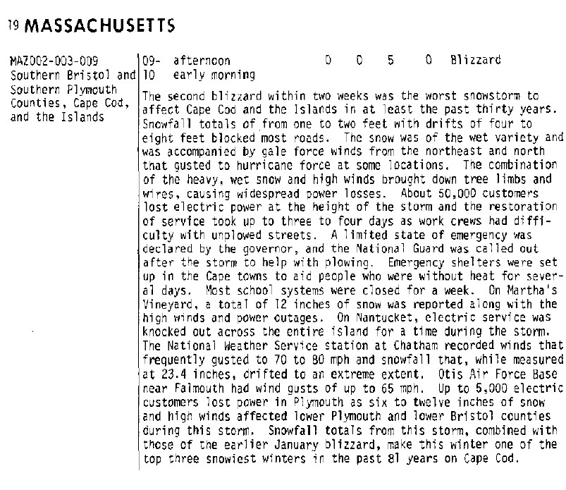
Does anyone have any stats on the January 1987/February 1987 blizzards? -
Yup. Get that out of the way and our ULL has space to breath and pump heights which slows the whole thing down that feature being there keeps the flow too fast and helps to drag everything east
-
95% chance I'll be dribbling out of my mouth asleep, dreaming about having to wash and blow dry a full head of hair when it comes out tonight. That job is for another.
-
It showed several inches 4 days before the last event .
-

Wednesday Feb 18 Mixed event. NOPE …ain’t happenin’
Typhoon Tip replied to HoarfrostHubb's topic in New England
This is the warm up after the 15th ... a 37 F WWA cancellation - priceless -
at lobe Less ridge amplification and that lobe over New England being further west resulted in that 12z euro run.
-
Thank you, you did an excellent job. Now rest up so you're ready when we need you to post the 0z UK kuch maps showing 27"
-
Ukie ensembles only because they may provide false hope.
(17).thumb.png.bfbf7212e32085d61910205edafa1f39.png)
-
A wider stripe but otherwise looks like today's miss. Maybe 1-2 here, and GYX has Monday as another miss (though that one's 5 days away and things will likely change a few more times).
-
Some people act stupid. Others aren't acting.
-

Late February/Early March 2026 Mid-Long Range
SnowenOutThere replied to WxUSAF's topic in Mid Atlantic
Wait and see what'll happen. I don't really care to synoptically analyze this like I did with our December storms and January event because unfortunately the more likely outcome as of now is no snow. Most ens keep the possibility of an inch of snow somewhere in the 40-60% range which frankly shows this isn't worth getting excited over. Just need to pray that the H5 pass trends further south or west depending on the model to capture the surface low in the ideal spot. Nothing we can do but hurry up and wait.


(17).png.4eba42d3dc3d67c21c8813b177925355.png)
