All Activity
- Past hour
-

E PA/NJ/DE Winter 2025-26 Obs/Discussion
Birds~69 replied to LVblizzard's topic in Philadelphia Region
Then there goes our snowpack with slush, ponding and junk. I'm a greedy weenie...want to keep the snowpack and add by nickel/dime or get plastered again. 16F/Sunny -

Possible coastal storm centered on Feb 1 2026.
ineedsnow replied to Typhoon Tip's topic in New England
BOX drunk cant even get the day right NWS Boston @NWSBoston You may have heard rumblings about a possible winter storm this weekend. While Sunday is a possibility, it’s only Wednesday and uncertainty remains high. Outcomes range from little or no impact to a more significant storm. Stay tuned for updates #MAwx #CTwx #RIwx -

The “I bring the mojo” Jan 30-Feb 1 potential winter storm
USCG RS replied to lilj4425's topic in Southeastern States
Two things with this storm 1) Where and exactly how the ULL progresses will large changes in sensible weather and thus forecasts 2) Banding will be a large portion of this storm Both of these are changes that can be just a few miles which is nearly impossible to predict. That withstanding, closer to the coast has more wiggle room here as the storm is exploding off the coast. Likewise, forum wide this looks like a good hit as the ULL is favorable for most of the area... It would appear. -
Yes. Sort of the national NWS office
-
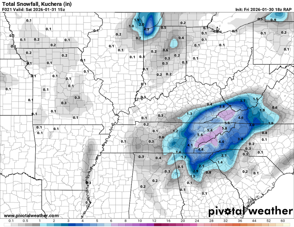
New update: Winter Storm Warning URGENT - WINTER WEATHER MESSAGE National Weather Service Morristown TN 1248 PM EST Fri Jan 30 2026 TNZ014-015-037>039-068>071-073-086-VAZ001-310915- /O.CON.KMRX.WS.W.0003.260130T1800Z-260201T0600Z/ Claiborne-Hancock-Union-Grainger-Hamblen-Loudon-Knox-Jefferson- Northwest Blount-North Sevier-Northwest Monroe-Lee- Including the cities of Lenoir City, Maynardville, Luttrell, Morristown, Arthur, Happy Valley, Pigeon Forge, Springdale, Evanston, Sharps Chapel, Seymour, Sneedville, Treadway, Knoxville, Bullet Creek, White Pine, Bean Station, Kyles Ford, Lake Forest, Strawberry Plains, Chestnut Hill, Rose Hill, Russellville, McMahan, Madisonville, Bearden, Jefferson City, Dandridge, Kodak, Harrisburg, Sevierville, Alpha, Harrogate-Shawanee, Loudon, Clairfield, Lone Mountain, Paulette, Sweetwater, Sandlick, Norris Lake, Alcoa, Maryville, and Howard Quarter 1248 PM EST Fri Jan 30 2026 ...WINTER STORM WARNING REMAINS IN EFFECT UNTIL 1 AM EST SUNDAY... * WHAT...Heavy snow expected. Total snow accumulations between 3 to 9 inches. Winds gusting as high as 35 mph. * WHERE...3 to 6 inches of snow are expected between Lee County VA and south toward the I-40 corridor in TN. 4 to 7 inches along the I-40 corridor and south toward the foothills of the east TN mountains. Locally higher amounts up to 9 inches across the foothills of the east TN mountains. * WHEN...Until 1 AM EST Sunday. * IMPACTS...Travel could become difficult by this evening. Hazardous travel conditions are expected overnight into Saturday. PRECAUTIONARY/PREPAREDNESS ACTIONS... If you must travel, keep an extra flashlight, food, and water in your vehicle in case of an emergency. The latest road conditions for the state you are calling from can be obtained by calling 5 1 1. && $$
-

The “I bring the mojo” Jan 30-Feb 1 potential winter storm
Regan replied to lilj4425's topic in Southeastern States
Yeah they removed that higher area to the west. -

Central PA Winter 25/26 Discussion and Obs
Mount Joy Snowman replied to MAG5035's topic in Upstate New York/Pennsylvania
Not seeing much model support for mid-next week but still a ways to go. Might have to wait until the clipper swings through later in the week toward the weekend. -

The “I bring the mojo” Jan 30-Feb 1 potential winter storm
wakegrrl replied to lilj4425's topic in Southeastern States
That's what they're showing for Apex as well. Makes sense to me. -

February 2026 Medium/ Long Range Discussion: Buckle Up!
Fozz replied to Weather Will's topic in Mid Atlantic
That’s because 2013-14 (especially early on) was very frustrating for the immediate metros while those who live N/W kept getting buried. -
-

Jan 30th-February 1st 2026 Arctic Blast/ULL Snow OBS Thread.
bearman replied to John1122's topic in Tennessee Valley
Yeah I have sun here again in Knoxville. Without anything falling, I am beginning to get nervous that we are not going to overcome this. -

The “I bring the mojo” Jan 30-Feb 1 potential winter storm
JSB99 replied to lilj4425's topic in Southeastern States
The trend has definitely been our friend for NE Georgia. My point and click in Gainesville now shows 3-7" for tomorrow! -

The “I bring the mojo” Jan 30-Feb 1 potential winter storm
PackGrad05 replied to lilj4425's topic in Southeastern States
WRAL updated their map. -

Is we back? February discussion thread
Great Snow 1717 replied to mahk_webstah's topic in New England
Trust me on this there is next to nothing going on with the pack in Billerica...lol -

Pittsburgh/Western PA WINTER ‘25/‘26
SteelCity87 replied to Burghblizz's topic in Upstate New York/Pennsylvania
Seems like the only thing that can go wrong is the suppression that's being modeled now. Tons of time left though. -

Richmond Metro/Hampton Roads Area Discussion
Dick_LeBoof replied to RIC Airport's topic in Mid Atlantic
Whoa that's a big update for Richmond! Is the WPC a national-level group? -
He’s a trouble making fool is all.
-
* flurry. Sorry.
- 700 replies
-
- 1
-

-
- extreme cold
- snow
- (and 1 more)
-

Possible coastal storm centered on Feb 1 2026.
wx2fish replied to Typhoon Tip's topic in New England
Id bet NYC hits 32 early next week -
The “I bring the mojo” Jan 30-Feb 1 potential winter storm
Regan replied to lilj4425's topic in Southeastern States
I’ll take it, but the mets keep wiggling that rug despite models. Waiting on Allan Huffman update since he said he was editing now. if I look at this morning’s slides it’s got 6-8 over Wake -
Is we back? February discussion thread
Great Snow 1717 replied to mahk_webstah's topic in New England
In Billerica?? I was in Billerica around mid to late morning...what the hell are you talking about??? -

Richmond Metro/Hampton Roads Area Discussion
jlewis1111 replied to RIC Airport's topic in Mid Atlantic
hope they bust and RIC gets a foot -

Jan 30th-February 1st 2026 Arctic Blast/ULL Snow OBS Thread.
Carvers Gap replied to John1122's topic in Tennessee Valley
We've easily burned through at least an inch of accumulation just with melting. When I look at accumulation maps, I am thinking...well subtract one from that number already. Not a single flake is sticking. I am surprised, but interested to see what happens when the sun angle and temp drops. It isn't even remotely as cold as I thought it would be - we are above freezing. Rates are probably 10:1 if it was sticking. Right now it is 0:1. LOL. I have seen some snowstorms start like this, and then quickly ramp up. I have also seen busts start like this....IDK -

1-30/2-1-26 Arctic Blast, ULL Snow Event
Save the itchy algae! replied to John1122's topic in Tennessee Valley
Up to 38 here, feels like 60- 700 replies
-
- 1
-
-
- extreme cold
- snow
- (and 1 more)
-
Go look at my picture(picture doesn’t lie) I posted of the blacktop at my school, in direct sunlight all day, two pages back….And you’ll know you’re 100% wrong.


