All Activity
- Past hour
-

Central & Eastern Pacific Thread
BarryStantonGBP replied to Windspeed's topic in Tropical Headquarters
WTPA43 PHFO 102032 TCDCP3 Hurricane Henriette Discussion Number 27 NWS Central Pacific Hurricane Center Honolulu HI EP082025 Issued by NWS National Hurricane Center Miami FL 1100 AM HST Sun Aug 10 2025 Henriette’s been givin’ it the big’un today, lads! Proper eye showin’ off on the sat pics and the middle bit’s lookin’ sharper than Harry Kane on a counter-attack. The boffins had her pegged at 65 knots earlier, but she’s clearly upped her game, so we’ll call it a solid 70 kt for now. How strong will she get? Well, the set-up ahead looks sweet. Less of that wind shear nonsense, warmer waters, and cooler air upstairs (whatever that means). Translation: she’s in for a bit of a purple patch over the next day. The “models” didn’t see this one comin’, shock, so we’re gonna go full optimistic and give her near rapid intensification for the next 24 hours, until she runs into rougher conditions and bottles it. By 3 days in, she’ll be out over the cold stuff and get knackered, like England in the second half. Henriette’s leggin’ it northwest at a fair old pace, about 15 kt. Big ridge up top should keep her hoofin’ it in that direction for a few days, until she slows down when she’s had enough. Only change from the last call is she’s leggin’ it faster now, probably ‘cause she’s catchin’ a ride on some stronger winds aloft. FORECAST POSITIONS AND MAX WINDS INIT 10/2100Z 25.7N 152.5W 70 KT 80 MPH 12H 11/0600Z 27.3N 154.3W 80 KT 90 MPH 24H 11/1800Z 29.4N 156.9W 90 KT 105 MPH 36H 12/0600Z 31.5N 159.6W 85 KT 100 MPH 48H 12/1800Z 33.6N 162.3W 75 KT 85 MPH 60H 13/0600Z 35.5N 164.9W 60 KT 70 MPH 72H 13/1800Z 37.3N 167.3W 40 KT 45 MPH...POST-TROPICAL 96H 14/1800Z 41.0N 170.0W 20 KT 25 MPH...POST-TROP/REMNT LOW 120H 15/1800Z...DISSIPATED $$ Forecaster Baz “Up The ‘Pool” Stanton -

2025 Atlantic Hurricane Season
Kevin Reilly replied to BarryStantonGBP's topic in Tropical Headquarters
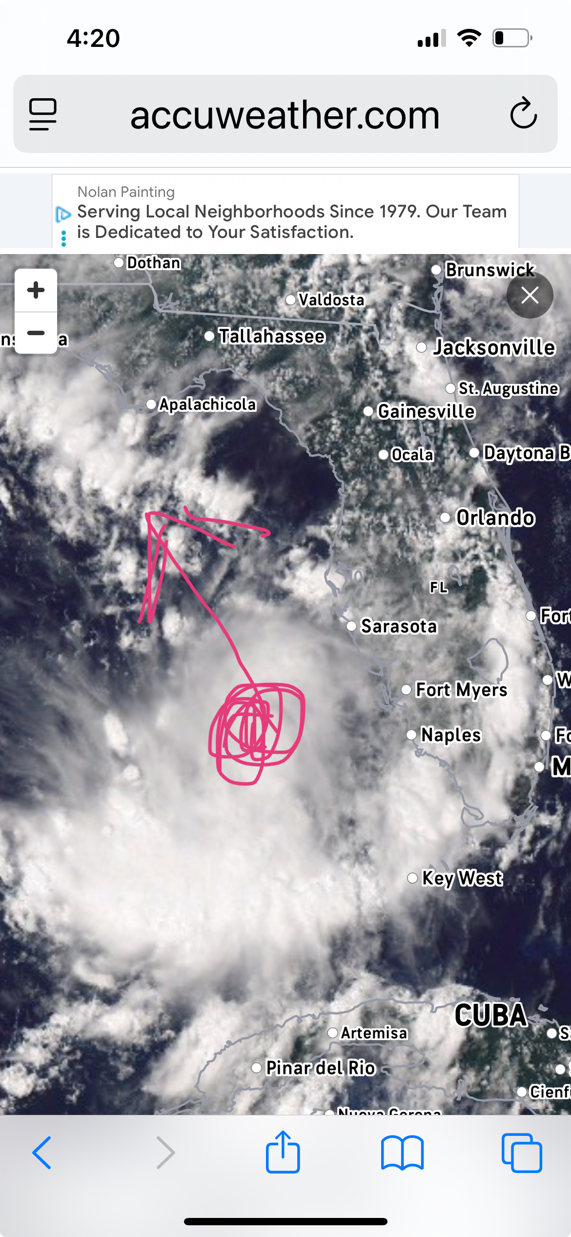
I would definitely watch this feature. My friend that lives along a canal in Cape Coral just NW of Fort Myers says that the canal is up to the top and water rises of about 2-3 feet are common right now. Looks like weak shear environment or about to be soon and steering currents look like South-southeast to NNW towards the Florida Panhandle. Looks like the upper air low sitting on top of Houston Texas and a push westbound will be the main steering features right about now. Unrelated to this but the blocking up north is very evident. Everything is moving from Halifax Nova Scotia all the way to Chicago all the way north and south. That is quite the blocking signal.
-
Central & Eastern Pacific Thread
BarryStantonGBP replied to Windspeed's topic in Tropical Headquarters
CAM ON HENRIETTE BAM BAM BAM SCORE SOME GOALS LASSIE Hurricane HENRIETTEAs of 18:00 UTC Aug 10, 2025: Location: 25.2°N 151.9°WMaximum Winds: 65 kt Gusts: N/AMinimum Central Pressure: 993 mbEnvironmental Pressure: N/ARadius of Circulation: N/ARadius of Maximum wind: 15 nm64 kt Wind Radii by Quadrant: Hurricane Henriette Satellite | Buoys | Grids | Storm Archive ...HENRIETTE RAPIDLY INTENSIFIES INTO A HURRICANE... ...FURTHER STRENGTHENING EXPECTED... GOOOOOOOAAAAAAALLLLLLL...... 11:00 AM HST Sun Aug 10 Location: 25.7°N 152.5°W Moving: NW at 17 mph Min pressure: 990 mb Max sustained: 80 mph Public Advisory #27 1100 AM HST Forecast Advisory #27 2100 UTC Forecast Discussion #27 1100 AM HST Wind Speed Probabilities #27 2100 UTC Productos en español: (más información) Aviso Publico Pronóstico Discusión Wind Speed Probabilities Arrival Time of Winds Wind History Warnings/Cone Interactive Map Warnings/Cone Static Images Experimental Cone Warnings and Surface Wind -
That latest convective burst may be enough to put it over the top.
-
 Mostly 89/90 out here in line with forecast highs
 -

2025-2026 ENSO
KakashiHatake2000 replied to 40/70 Benchmark's topic in Weather Forecasting and Discussion
yeah the youtube link treys or convective chronicles 2025 tornado season recap and forecast verification i posted in here seems to be sort of irreverent sorry about that but wasnt sure where to post it -
Not sure then. What browser are you using?
-
As you can see, I went ahead and found it. Plymouth only goes back to 2000. Anyway, here's the " evidence". Looks Nina to me. Although, close enough tri.month average one could classify as neutral I suppose with marginal spread.
-
There has definitely been an AO/NAO “disconnect” (they used to be positive together or negative together in the past) the last several years, whether it’s CC/arctic sea ice, possibly even solar cycle related is obviously open for debate. I read on twitter today that the new model runs are getting stronger with the -IOD for this fall. That anticipated -IOD/-ENSO combo, SST alignment, supports MJO 4-5-6-7 (“Niña like phases) being dominant. Not that such low frequency forcing is any surprise given the last several years….
-
-
 90 First day of Heatwave #6
 -

E PA/NJ/DE Summer 2025 Obs/Discussion
Hurricane Agnes replied to Hurricane Agnes's topic in Philadelphia Region
Like saying "Beetlejuice, Beetlejuice, Beetle..." and there you are. Pulled out the hose this afternoon ahead of the upcoming mini-heatwave. Currently at my high (so far) of 87 with dp 64, which is still reasonable (not too bad out). -
Home Davis hit 91, good pool day.
-

E PA/NJ/DE Summer 2025 Obs/Discussion
Albedoman replied to Hurricane Agnes's topic in Philadelphia Region
Drought guy says cmon baby. Only a major hurricane riding up the coast will be our savior. The corn is already spiking in western lehigh county. Everone else east of s mountain got inches of rain as we got zilch .....lots of complaints about turning off the normal rain pattern in july. This what you get brown lawns everwhere here in lower macungie. We have been the screw zone since mid july. -
Another nice day. Humidity a touch higher. 82/62 Getting bit outside working on the deck. Asian Tiger season now. Bastards are small but itch like crazy. Not many but just enough to find you, and as dry as it is they don't need much water to breed. Empty plant saucers etc.
-
Yeah, I always considered it a weak Nina . From what I recollect, SST'S showed that. Somebody go dig up archived plots from then. I just don't feel up to it. I used to have those at disposal many years ago. I'm sure Plymouth State still has those. A side note; I think that Winter would of had more Nina Characteristics albeit weak, had it not been for repeated textbook strong blocking.
-
 Temperatures topped out several degrees above the guidance today, in part to abnormally dry conditions. The region is off to its driest starrt to August since 2010. During the first 10 days of August, the combined total precipitation for Bridgeport, Islip, Central Park, JFK Airport, LaGuardia Airport, and Newark is 0.23". That is the lowest figure since August 1-10, 2010 when just 0.13" was measured. In stark contrast, August 1-10, 2024 had already seen 23.25" of rain. Aside from some showers or thundershowers Wednesday night into Thursday morning, mainly dry conditions will likely persist through at least the next weekend. The ongoing warming trend will continue. The region will likely experience a return of 90° or above heat this week. Newark already reached 90° today for the 32nd time this year. LaGuardia Airport also reached 90°. Temperatures could top out in the middle or perhaps even upper 90s in the hot spots when the heat peaks during the Tuesday through Thursday period. The ENSO Region 1+2 anomaly was +0.4°C and the Region 3.4 anomaly was -0.3°C for the week centered around July 30. For the past six weeks, the ENSO Region 1+2 anomaly has averaged +0.37°C and the ENSO Region 3.4 anomaly has averaged -0.08°C. Neutral ENSO conditions will likely continue through the summer. The SOI was -14.51 today. The preliminary Arctic Oscillation (AO) was -0.173 today. Based on sensitivity analysis applied to the latest guidance, there is an implied 53% probability that New York City will have a warmer than normal August (1991-2020 normal). August will likely finish with a mean temperature near 76.4° (0.3° above normal). Supplemental Information: The projected mean would be 1.2° above the 1981-2010 normal monthly value.
 -
 89.0 in Muttontown and 88.4 in Syosset for the highs. Not much above forecast this morning which was 87, as I recall.
 -
What are your early thoughts for analogs? I haven’t been following things too closely the past couple of months, but reading the past few pages and latest guidance it looks like things have trended more in favor of a La Niña rather than cold neutral. You think ENSO will be weaker or stronger than last year?
-
2025-2026 ENSO
KakashiHatake2000 replied to 40/70 Benchmark's topic in Weather Forecasting and Discussion
i have no clue where to put this so im putting it here this is treys or convective chronicles 2025 tornado season recap and forecast verification - Today
-

2025-2026 ENSO
Stormchaserchuck1 replied to 40/70 Benchmark's topic in Weather Forecasting and Discussion
I agree that 97L will likely stay out to sea, as CV storms passing NE of 60W/20N, stay out to sea historically 90% of the time. The ones that break that have a huge +H5 ridge over the top after it passes that point, and models don't currently have that. -
 92 earlier. Way above forecast
 -
 Brown lawns across the CT Shoreline as BDR is working on their #1 driest summer on record and 6th warmest. Time Series Summary for IGOR I SIKORSKY MEMORIAL AIRPORT, CT Driest June 1st through August 9th Click column heading to sort ascending, click again to sort descending. 1 2025-08-09 2.34 0 2 1966-08-09 2.58 0 3 1999-08-09 2.72 0 4 1993-08-09 3.06 0 5 1964-08-09 3.37 0 6 1957-08-09 3.84 0 7 1994-08-09 3.99 0 8 1995-08-09 4.01 0 9 1955-08-09 4.08 0 10 1970-08-09 4.11 0 Time Series Summary for IGOR I SIKORSKY MEMORIAL AIRPORT, CT Warmest June 1st Through August 9th Click column heading to sort ascending, click again to sort descending. 1 2010-08-09 75.3 0 2 2020-08-09 75.2 0 3 2024-08-09 75.1 0 4 1994-08-09 75.0 0 5 2008-08-09 74.4 0 6 2025-08-09 74.3 0 7 2019-08-09 74.2 0 - 2016-08-09 74.2 0 - 2012-08-09 74.2 0 - 2011-08-09 74.2 0 - 1949-08-09 74.2 0 8 2013-08-09 74.1 0 9 2022-08-09 74.0 0 - 1999-08-09 74.0 0 10 1993-08-09 73.7 0 CT ANSONIA 1 NW COOP 2.20 CT IGOR I SIKORSKY MEMORIAL AIRPORT WBAN 2.34 NY BAYPORT 1.0 SSE CoCoRaHS 2.40 NJ HAWTHORNE 1.0 SSE CoCoRaHS 2.75 NJ RIVER VALE TWP 1.5 S CoCoRaHS 2.84 NJ CEDAR GROVE TWP 0.4 W CoCoRaHS 2.84 NY SHELTER ISLAND HEIGHTS 2.1 SSW CoCoRaHS 2.95 NY SAYVILLE 0.0 N CoCoRaHS 2.96 CT FAIRFIELD 1.5 NE CoCoRaHS 3.01 CT STRATFORD 0.9 W CoCoRaHS 3.05 CT GUILFORD CENTER 2.7 WSW CoCoRaHS 3.11 CT WATERFORD 2.3 S CoCoRaHS 3.17 CT WALLINGFORD CENTER 1.1 N CoCoRaHS 3.18
 -
The Lawson’s cosmic IPA and the Schilling Pilsner are both delicious.
-
Past few nights have been so nice. I wish summer had more days like that. I remember many nights like these as a kid in the 90's but I swear it's just unbearably hot and humid most nights now. My parents didn't have AC upstairs as a kid so we always slept with the house fan or downstairs depending on how hot it was.


.thumb.png.4150b06c63a21f61052e47a612bf1818.png)

