All Activity
- Past hour
-
It's amazing how I went from bitching that every weekend had precipitation to my yard having rock hard soil and dormant grass. This morning the dews just hit me different, like I'm really starting to get sick of them. I don't like them to begin with but I do my best to embrace whatever weather we have but this morning might have been my breaking point LOL
-
 Did your power go out, or internet? .80" yesterday
 -
Looks like it warms uo to the 90s again the weekend after when Erin passes. What a summer.
-
Some of us knew while a select few prayed it wouldn’t be true.
-
 0.50" for me last night, good for the grass and garden but we definitely need more
 -

E PA/NJ/DE Summer 2025 Obs/Discussion
JTA66 replied to Hurricane Agnes's topic in Philadelphia Region
Temps overperformed yesterday, I topped out at 91F before the clouds rolled in. That's 2 days in a row of 90+. Picked up .65" of rain yesterday taking my monthly total to .67". -
Take it away for working class consumers while they give it to big corporations and big banks instead? Socialism for the rich, individualism for everyone else…
-
was going to comment on this... yup All major ens-derived, sweeping numerical index changes. Well represented in the spatial depictions, too. A significant overhaul of the hemispheric foot pattern mode. Not sure if that represents the end of summer but ...considering D10 enters the last week of August... modulate for climatology accordingly.
-
 77 / 73 warm / muggy and partly cloudy. With enough clearing the heatwave extends with most upper 80s / low 90s. Scattered showers today. A bit cooler and a likely pause in the 90s Friday and Saturday even in the hot areas with mid 80s / upper 80s perhaps a stray 90 in the NJ inland areas. Hot on Sunday with a w/wnw flow could push temps into the mid 90s (95+) in the hottest areas. Cooler by Monday as Erin comes up offshore then recurves. Near normal Wed - next weekend, with a surge of warm/hot ahead of the trough next weekend - sneaky 90s perhaps. Trough into the northeast by the 24th. Ridging building east with expanding heat from the west to close the final 2 - 3 days of the month. 8/14 - 8/18: Warm - hot - hottest Thu/ Sunday. only scattered showers Thu / Isolated Sat-Sun-Mon 8/19 - 8/24 : Cooler / near normal perhaps a sneaky push of warmth 8/22-23 as Erin pulls aways 8/25 - 8/28 : Cooler / trough north east below normal 8/29 - Beyond : Warmer - Ridge building east - Warmer overall - potential heat
 -
Wow you usually fair better than I do down here. That being said my FIL is coming up next week. He is the one who helped me dig up a small street side patch of dead grass and roll sod down back in April when they were here. He will arrive seeing that it has yet again a patch of dead grass.
-
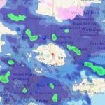
The cool weather potential might have been reduced a bit, but still better next week than this week. The core of the heat settles in the West.
.thumb.png.665c667bbc4596f57db28041a082205c.png)
-
This did work out for some areas of the upper Eastern Shore last evening. Chesapeake City with over 2 inches, my location with 1.50 inches.
-
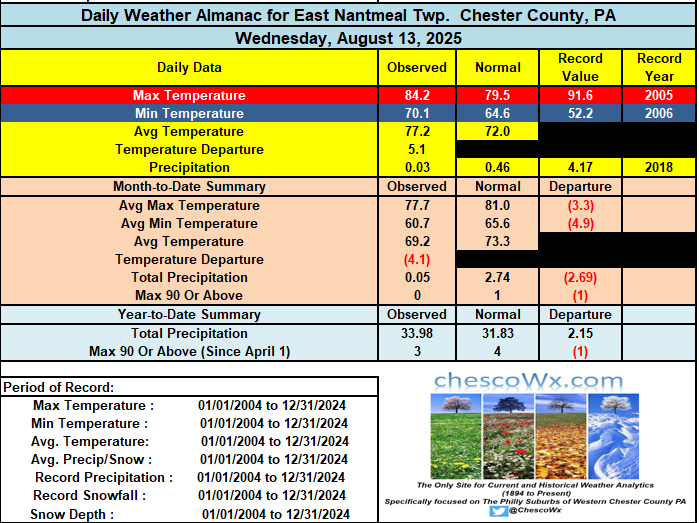
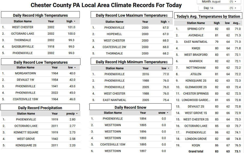
Most folks across the north and west parts of the county saw little rain (under 0.05")....much different across other spots with West Grove 1.39" / Nottingham 2.33" / Avondale 1N 0.55" / Kennett Square 1.26" / Devault 1.70". We do have a chance at some more showers this afternoon. Mainly dry and sunny weather looks likely for the weekend. Of note most spots across Chester County have not experienced any days over 90 degrees so far here in August. The exceptions were West Chester and Devault yesterday. Most spots in the county look to have potentially their next shot at a 90-degree temperature on Sunday with highs well into the 80's. As we move through next week temperatures begin to cool back down to not far from normal levels with some higher spots seeing highs mainly in the 70's by mid-week.
-
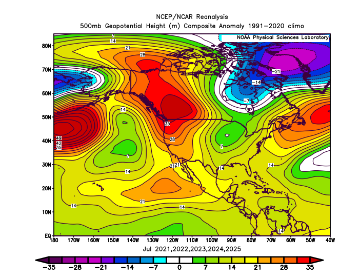
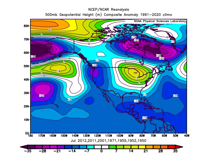
There has been a new relationship between the -PDO and PNA especially during the 2020s summers. This was our first July streak of 5 consecutive -2 to -4 -PDOs. There has been a very strong +PNA signal leading to the record wildfires, record heat, and drought up in Canada. Past instances of -2 -PDOs in July were more -PNA. My guess is that this is related to the -PDO being more driven by the warmer SST anomalies than the colder ones which used to dominate -PDOs in the past. Recent July -2 to -4 -PDOs have been more +PNA Older -PDO below -2 in July were more -PNA
-

E PA/NJ/DE Summer 2025 Obs/Discussion
ChescoWx replied to Hurricane Agnes's topic in Philadelphia Region
Most folks across the north and west parts of the county saw little rain (under 0.05")....much different across other spots with West Grove 1.39" / Nottingham 2.33" / Avondale 1N 0.55" / Kennett Square 1.26" / Devault 1.70". We do have a chance at some more showers this afternoon. Mainly dry and sunny weather looks likely for the weekend. Of note most spots across Chester County have not experienced any days over 90 degrees so far here in August. The exceptions were West Chester and Devault yesterday. Most spots in the county look to have potentially their next shot at a 90-degree temperature on Sunday with highs well into the 80's. As we move through next week temperatures begin to cool back down to not far from normal levels with some higher spots seeing highs mainly in the 70's by mid-week.
-
Looks like the cool down starts Monday.
-
 Same in northern Westchester!
 -
1.7" in Akron yesterday. Funny thing is that it didnt "feel" like that much. Ida guessed half of that tops. Happy pre Friday all.
-
 .28 imby..not impressed
 -

2025-2026 ENSO
40/70 Benchmark replied to 40/70 Benchmark's topic in Weather Forecasting and Discussion
Yea, the PDO and PNA part ways relatively frequently, as was the case last season. This is probably why the PNA in many of my analogs isn't as negative as you seem to think. -

E PA/NJ/DE Summer 2025 Obs/Discussion
BBasile replied to Hurricane Agnes's topic in Philadelphia Region
I've had 5.14" since June 1. Not drought worthy, but not good, either. -
The 00z CAMs were quite bullish on afternoon convection, especially over central Maryland, but the 06z NAM Nest and recent HRRR runs have backed way off.
-
Better than my T on the north side of town
-
My main reason is the PDO which can obviously change between now and December. Maybe I should have been clearer, not a total elimination, but it would be the very last on my analog list as of now
-
2025-2026 ENSO
40/70 Benchmark replied to 40/70 Benchmark's topic in Weather Forecasting and Discussion
Don't get me wrong....I try to be pretty objective and back you up on plenty of takes, but you seem to be reaching here to eliminate that season from consideration altogether. The MEI hasn't been update since May, so perhaps you are mistaken. The RONI is -.40 and rising....


.png.e1c4baae78d7347e65e49f6942a1c8fb.png)