All Activity
- Past hour
-

2025 Spring/Summer Mountain Thread
wncsnow replied to Maggie Valley Steve's topic in Southeastern States
Just had some small hail in a non warned storm in McDowell -
See my post above. Apparently it works on all children.
-
Funny how this run of cold weather quiets the all-hot all the time boyz. You just know It would be non-stop talk about installs or how hot it is in Pelham, Swansea , Seekonk or some other far-flung delivery location.
-
My classroom gets disgusting when it’s hot and humid. The kids get cranky. In cool/dreary weather they act a bit calmer.
-
I thought you were a teacher? How does It make your job easier? Canceled field day?
-
It's perfect for some heavy gardening. I was digging rows for zucchini and hardly a drip of sweat this evening. My garden liked that warm humid weather we had a couple days ago. I perfer the cool dry weather.
-
This supercell that just crossed the Tennessee River into southern Madison County, AL is likely having a tornado skipping back and forth above near Owens Crosssroads, Hampton Cove, and New Hope. It has shown a tornado debris signature multiple times in the past 10 minutes. Tornado Warning ALC071-089-095-103-210100- /O.NEW.KHUN.TO.W.0047.250521T0030Z-250521T0100Z/ BULLETIN - EAS ACTIVATION REQUESTED Tornado Warning National Weather Service Huntsville AL 730 PM CDT Tue May 20 2025 The National Weather Service in Huntsville Alabama has issued a * Tornado Warning for... Northwestern Marshall County in northeastern Alabama... West central Jackson County in northeastern Alabama... Southern Madison County in north central Alabama... East central Morgan County in north central Alabama... * Until 800 PM CDT. * At 730 PM CDT, a severe thunderstorm capable of producing a tornado was located near Morgan City, or near Redstone Arsenal, moving east at 30 mph. HAZARD...Tornado. SOURCE...Radar indicated rotation. IMPACT...Flying debris will be dangerous to those caught without shelter. Mobile homes will be damaged or destroyed. Damage to roofs, windows, and vehicles will occur. Tree damage is likely. * This dangerous storm will be near... Owens Cross Roads and Huntsville around 735 PM CDT. Other locations impacted by this tornadic thunderstorm include Paint Rock, Laceys Spring, Farley, Garth, Hampton Cove, Whitesburg, and Brownsboro. PRECAUTIONARY/PREPAREDNESS ACTIONS... TAKE COVER NOW! Move to a basement or an interior room on the lowest floor of a sturdy building. Avoid windows. If you are outdoors, in a mobile home, or in a vehicle, move to the closest substantial shelter and protect yourself from flying debris. && LAT...LON 3448 8666 3469 8668 3481 8626 3450 8625 TIME...MOT...LOC 0030Z 269DEG 28KT 3455 8659 TORNADO...RADAR INDICATED MAX HAIL SIZE...<.75 IN $$ KTW
-
6 foot 170 lbs and I walked 10 miles a week before I injured my back in late 2023. I hate the heat. I hate high dews even more. Today was an exquisite day, another 10/10.
-
Nice high of 45 here Thursday. I don’t love it but makes my job easier.
-
Looks absolutely horrible this week. What a way to ring in the start of summer.
-
There are 2 tornado debris signatures in Jackson County, AL with this supercell. Tornado Warning ALC049-071-TNC051-210100- /O.NEW.KHUN.TO.W.0046.250521T0021Z-250521T0100Z/ BULLETIN - EAS ACTIVATION REQUESTED Tornado Warning National Weather Service Huntsville AL 721 PM CDT Tue May 20 2025 The National Weather Service in Huntsville Alabama has issued a * Tornado Warning for... Jackson County in northeastern Alabama... Northeastern DeKalb County in northeastern Alabama... Southeastern Franklin County in Middle Tennessee... * Until 800 PM CDT. * At 721 PM CDT, a tornado producing storm was located near Skyline, or 10 miles northwest of Scottsboro, moving northeast at 40 mph. HAZARD...Damaging tornado. SOURCE...Radar confirmed tornado. IMPACT...Flying debris will be dangerous to those caught without shelter. Mobile homes will be damaged or destroyed. Damage to roofs, windows, and vehicles will occur. Tree damage is likely. * This tornadic storm will be near... Skyline around 725 PM CDT. Stevenson around 740 PM CDT. Bridgeport around 755 PM CDT. Other locations impacted by this tornadic thunderstorm include Bass, Martintown, Princeton, Lim Rock, Jericho, Russell Cave National Monument, Estillfork, Fackler, Hytop, and Anderson. PRECAUTIONARY/PREPAREDNESS ACTIONS... To repeat, a tornado is on the ground. TAKE COVER NOW! Move to a basement or an interior room on the lowest floor of a sturdy building. Avoid windows. If you are outdoors, in a mobile home, or in a vehicle, move to the closest substantial shelter and protect yourself from flying debris. && LAT...LON 3462 8627 3488 8629 3508 8586 3499 8586 3499 8573 3469 8557 TIME...MOT...LOC 0021Z 247DEG 36KT 3477 8616 TORNADO...OBSERVED MAX HAIL SIZE...<.75 IN $$ GH
-
Absolutely majestic basketball weather
-
This one has a debris ball on the Hytop (NWS Huntsville) radar. Tornado Warning Severe Weather Statement National Weather Service Huntsville AL 710 PM CDT Tue May 20 2025 ALC071-089-210030- /O.CON.KHUN.TO.W.0044.000000T0000Z-250521T0030Z/ Jackson AL-Madison AL- 710 PM CDT Tue May 20 2025 ...A TORNADO WARNING REMAINS IN EFFECT UNTIL 730 PM CDT FOR NORTHWESTERN JACKSON AND NORTHEASTERN MADISON COUNTIES... At 709 PM CDT, a confirmed tornado was located near New Market, or 7 miles east of Moores Mill, moving east at 30 mph. Debris signiture seen north of Gurley. HAZARD...Damaging tornado and two inch hail. SOURCE...Radar confirmed tornado. IMPACT...Flying debris will be dangerous to those caught without shelter. Mobile homes will be damaged or destroyed. Damage to roofs, windows, and vehicles will occur. Tree damage is likely. Locations impacted include... Maysville, Skyline, Princeton, Estillfork, Brownsboro, Larkin, Gurley, Pleasant Groves, Trenton, and Garth. PRECAUTIONARY/PREPAREDNESS ACTIONS... To repeat, a tornado is on the ground. TAKE COVER NOW! Move to a basement or an interior room on the lowest floor of a sturdy building. Avoid windows. If you are outdoors, in a mobile home, or in a vehicle, move to the closest substantial shelter and protect yourself from flying debris. && LAT...LON 3468 8653 3489 8648 3499 8617 3473 8609 TIME...MOT...LOC 0009Z 254DEG 26KT 3482 8639 TORNADO...OBSERVED MAX HAIL SIZE...2.00 IN $$ GH
-
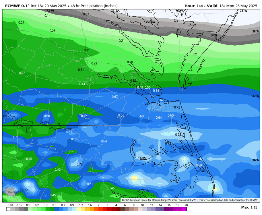
WB 18Z EURO...iffy beach weekend Sunday/Monday period, but still early.
-

2025-2026 ENSO
Stormchaserchuck1 replied to 40/70 Benchmark's topic in Weather Forecasting and Discussion
AAO correlation worked out last year - It was a very negative Aug/Sept AAO, and that rolled forward to a pretty strong signal on a cold December/January, -AO, North Pole was +0.5 correlation rolled forward. AAO has been very positive March - May, all but like 5 days positive. How that rolls forward to the following N. Hemisphere Winter +9 months is a lot of time, but it's an ok signal. This is what I would think +AAO would look like down the line (slight correlation with AO/EPO) -
Did NWS Nashville lose power or shelter? All of their warnings and updates are coming from NWS Fort Worth the past 20 minutes
-
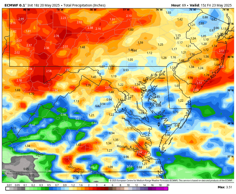
WB 18Z EURO for midweek.
-
18Z GFS does as well
- Yesterday
-
I'd actually be surprised If it doesn't happen.
-
18z NAM is cold Thursday night.. flakes for some
-

2024-2025 La Nina
ChalkHillSnowNut replied to George001's topic in Weather Forecasting and Discussion
I saw an article saying Antarctic ice grew the last year for the first time in a decade- -
Hopefully our north Alabama and Nooga area folks are ready to shelter.
-
Tornado Warning Tornado Warning ALC071-089-210030- /O.NEW.KHUN.TO.W.0044.250520T2344Z-250521T0030Z/ BULLETIN - EAS ACTIVATION REQUESTED Tornado Warning National Weather Service Huntsville AL 644 PM CDT Tue May 20 2025 The National Weather Service in Huntsville Alabama has issued a * Tornado Warning for... Northwestern Jackson County in northeastern Alabama... Central Madison County in north central Alabama... * Until 730 PM CDT. * At 644 PM CDT, a confirmed large and extremely dangerous tornado was located over University Of Alabama In Huntsville, or near Huntsville, moving east at 30 mph. This is a PARTICULARLY DANGEROUS SITUATION. TAKE COVER NOW! HAZARD...Damaging tornado. SOURCE...Emergency management confirmed tornado. IMPACT...You are in a life-threatening situation. Flying debris may be deadly to those caught without shelter. Mobile homes will be destroyed. Considerable damage to homes, businesses, and vehicles is likely and complete destruction is possible. * The tornado will be near... Alabama A And M University, Moores Mill, and Huntsville around 650 PM CDT. Other locations impacted by this tornadic thunderstorm include Maysville, Princeton, Estillfork, Pleasant Groves, Trenton, Garth, Ryland, Hollytree, Brownsboro, and Larkin. PRECAUTIONARY/PREPAREDNESS ACTIONS... To repeat, a large, extremely dangerous and potentially deadly tornado is on the ground. To protect your life, TAKE COVER NOW! Move to a basement or an interior room on the lowest floor of a sturdy building. Avoid windows. If you are outdoors, in a mobile home, or in a vehicle, move to the closest substantial shelter and protect yourself from flying debris. && LAT...LON 3465 8668 3482 8674 3499 8617 3473 8609 TIME...MOT...LOC 2344Z 254DEG 26KT 3476 8663 TORNADO...OBSERVED TORNADO DAMAGE THREAT...CONSIDERABLE MAX HAIL SIZE...2.00 IN $$ KTW
-
It would be interesting to see what kind of summers we generally have after a cool May. May is close enough to summer to serve as some gage I take it?
-
There is a large tornado on the ground in Madison County, AL near Madison right now headed towards the northside of Huntsville Tornado Warning 5/20/2025 19:24 EDT through 5/20/2025 19:45 EDT Tornado Warning issued May 20 at 6:24PM CDT until May 20 at 6:45PM CDT by NWS Huntsville AL ...A TORNADO WARNING REMAINS IN EFFECT UNTIL 645 PM CDT FOR SOUTHWESTERN MADISON AND SOUTHEASTERN LIMESTONE COUNTIES... At 622 PM CDT, a confirmed large and destructive tornado was located near Madison, moving east at 35 mph. TORNADO EMERGENCY FOR WESTERN MADISON AND EASTERN LIMESTONE COUNTY. This is a PARTICULARLY DANGEROUS SITUATION. TAKE COVER NOW! HAZARD...Deadly tornado. SOURCE...Radar confirmed tornado. IMPACT...You are in a life-threatening situation. Flying debris may be deadly to those caught without shelter. Mobile homes will be destroyed. Considerable damage to homes, businesses, and vehicles is likely and complete destruction is possible. The tornado will be near... Madison and Huntsville around 630 PM CDT. University Of Alabama In Huntsville and Redstone Arsenal around 635 PM CDT. Alabama A And M University around 645 PM CDT. Other locations impacted by this tornadic thunderstorm include Belle Mina, French Mill, Mooresville, Capshaw, Ryland, Hampton Cove, Ripley, Brownsboro, and Farley. Instructions To repeat, a large, extremely dangerous, and potentially deadly tornado is on the ground. To protect your life, TAKE COVER NOW! Move to an interior room on the lowest floor of a sturdy building. Avoid windows. If in a mobile home, a vehicle or outdoors, move to the closest substantial shelter and protect yourself from flying debris.


