All Activity
- Past hour
-
 started snowing ~11AM Sunday, ended somewhere around 11PM Monday. solid 36 hours of snow. picked up 12" Sunday (mostly arctic sand), and another 6" of pure fluff through the day on Monday. Fun storm.
 -
What a great line: Nobody is "owed" snow. I bet there are a few on this forum who disagree.
-

The “I bring the mojo” Jan 30-Feb 1 potential winter storm
BornAgain13 replied to lilj4425's topic in Southeastern States
Looking at the 6z GFS , if u toggle back a couple of runs, it was trending to what it showed at 6z. If only we could get it to hold. Having lost the Euro i have my doubts. -
21.0"
-

Central PA Winter 25/26 Discussion and Obs
Itstrainingtime replied to MAG5035's topic in Upstate New York/Pennsylvania
Oh, don't worry...he posted the same thing in the Philly thread. And in the MA thread... He's got one agenda and I hope a mod can send him packing. He's right about one thing...he said he isn't Ji, and he's right. Ji can be a pita but he does add a ton of value. Mickey is here to troll and troll only. -

Southern MD / Lower Eastern Shore weather discussion
PrinceFrederickWx replied to PrinceFrederickWx's topic in Mid Atlantic
This is probably an event we’re all gonna have to track ITT as the main subforum (mostly outside our area) have largely given up. -
Being in charlotte im just gonna go ahead and stay down here for when that storm finally misses to the east.
-

The “I bring the mojo” Jan 30-Feb 1 potential winter storm
franklin NCwx replied to lilj4425's topic in Southeastern States
When we need the phase it misses -
 PWM event total 14.2" / 0.92" Depth 14" (was 4" prior to the storm)
 -
The “I bring the mojo” Jan 30-Feb 1 potential winter storm
BornAgain13 replied to lilj4425's topic in Southeastern States
6z Euro just disappeared well east. -
I will say this - I agree it is probably dead for the metro area(s). Sure, coastal/eastern sections are still in the game. But one huge caveat here...I know with remote sensing the whole "data sparse regions" argument is less valid - however, when we are dealing with some pretty small scale changes that can make big changes, I would probably at least mentally keep one eye on this until the s/w hits the west coast and the energy up in Canada (which is a mess of stuff flying around) is sampled/resolved better. I don't think it's going to make any huge shifts...but there might be a point where it gives us a little glimmer of hope here in the DC/Baltimore areas. Again...I think this is probably not the one for us here in the corridor...but just saying - there is still some data to be sampled by the upper air network that *might* contribute to changes. But as I said above - the ensembles all still look pretty solid into February. If the blocking really does recycle - we will probably get another chance or two to make bank. There are absolutely NO guarantees in this. I'm sure @Maestrobjwa will confirm this at this point. Nobody is "owed" snow. If it happens, it happens...if it doesn't, well it doesn't.
-
6 here
-
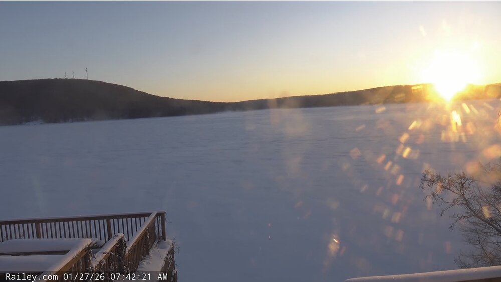
Captured this screenshot of the sun rising over Deep Creek Lake this morning from Railey Realty’s website. Low of -3 there.
-

January 2026 Medium/Long Range Discussion
SomeguyfromTakomaPark replied to snowfan's topic in Mid Atlantic
Yeah I’ll be watching for changes til at minimum 12z tomorrow. Pretty loaded situation in terms of potential. Models are swinging around run to run still so I don’t discount the possibility of big changes. -
Not the most encouraging trend. To note, there does not appear to be great member agreement on the low placement. AI EPS agreement is much closer to the coast, with a few major outliers way far out to sea skewing the group.
-

The “I bring the mojo” Jan 30-Feb 1 potential winter storm
PackGrad05 replied to lilj4425's topic in Southeastern States
Only worth watching trends until Thursday. At this point, the trend is for a more eastern NC system. Yes, that can change and there is still model uncertainty, but the trend is obvious right now. . -

The “I bring the mojo” Jan 30-Feb 1 potential winter storm
WiseWeather replied to lilj4425's topic in Southeastern States
That last frame though…. Looks a bit…. Um…. Flaccid. . -

Southern MD / Lower Eastern Shore weather discussion
csnavywx replied to PrinceFrederickWx's topic in Mid Atlantic
AI-GFS and EC-AIFS are on top of each other on this morning's 6Z run. Not much room to maneuver from here though. Gonna be a tough one unless we can get a faster tuck, neg tilt or a slightly stronger/amped and separated northern stream wave. -
Hey Good morning, still far away and these have been trending north lately so we have that on our side. GEFS look great but who can really trust them. Euro AI is so close
-

The “I bring the mojo” Jan 30-Feb 1 potential winter storm
Rsheely88 replied to lilj4425's topic in Southeastern States
Euro AI 6z . -

The “I bring the mojo” Jan 30-Feb 1 potential winter storm
StantonParkHoya replied to lilj4425's topic in Southeastern States
This is a Friday night start for parts of SC / coastal NC so we’re not far off from a timing standpoint . -
Really bad trends overnight. Need to see some improvement in next 24 hours or this is over
-
The “I bring the mojo” Jan 30-Feb 1 potential winter storm
BornAgain13 replied to lilj4425's topic in Southeastern States
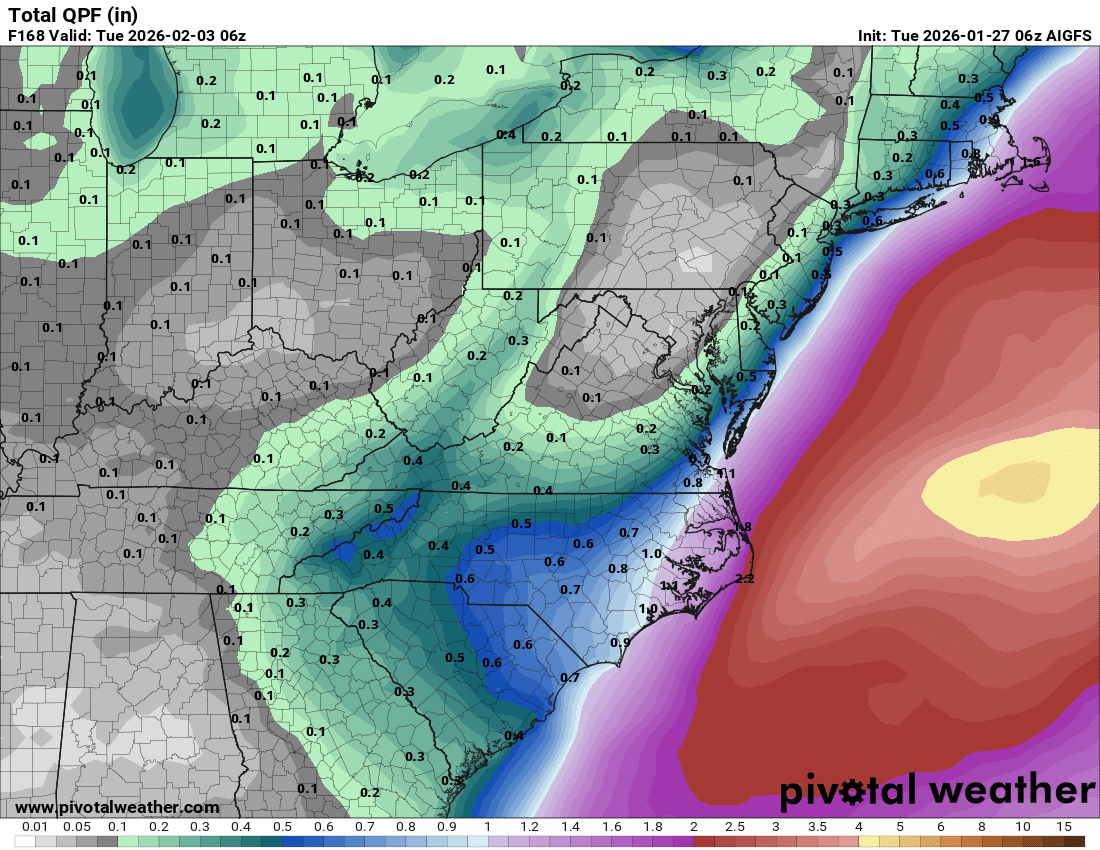
Did anyone mention the AI GFS? It trended much more west and NW with QPF. Taken verbatim it would be a big hit
-
06z EPS is east of previous runs
-

The “I bring the mojo” Jan 30-Feb 1 potential winter storm
ADB83 replied to lilj4425's topic in Southeastern States
Euro AI and WeatherNext 2.0 look pretty similar to my untrained eye. After all of this AI and model talk, I’m watching with interest those models relative to the traditional ones .