All Activity
- Past hour
-

February 2026 Medium/ Long Range Discussion: Buckle Up!
Fozz replied to Weather Will's topic in Mid Atlantic
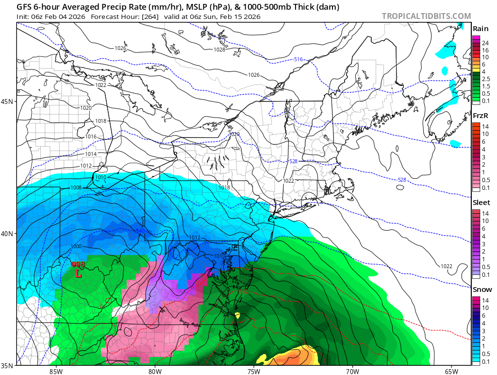
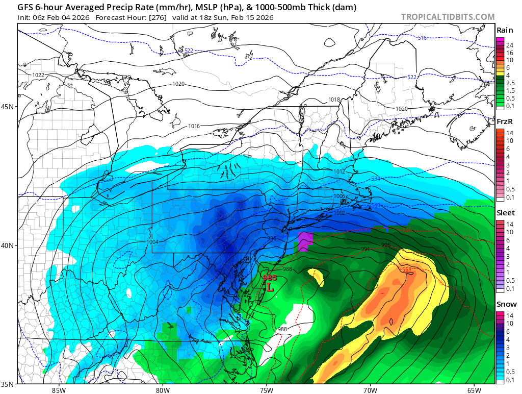
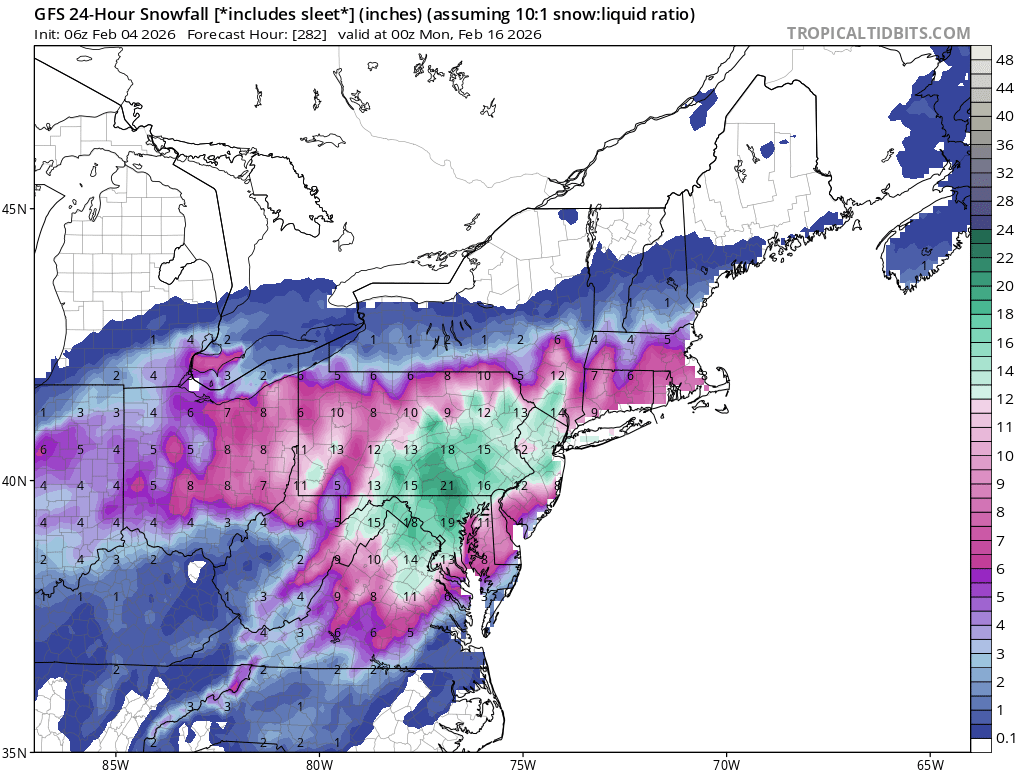
The GFS brings us PDIII -

Central PA Winter 25/26 Discussion and Obs
Jns2183 replied to MAG5035's topic in Upstate New York/Pennsylvania
This doesn't even feel like jacket weather. Yesterday afternoon wearing anything but a heavy sweatshirt felt like overkill Sent from my SM-S731U using Tapatalk -

February 2026 Medium/ Long Range Discussion: Buckle Up!
snowfan replied to Weather Will's topic in Mid Atlantic
6Z GFS OP is NSFW even if it is wrong.

-
Yeah I’ve had my eye on the PD weekend for a while. Looks like a big hit incoming on the GFS. ETA: GFS taken verbatim is a PDIII
-
Boom
-
Boom

-
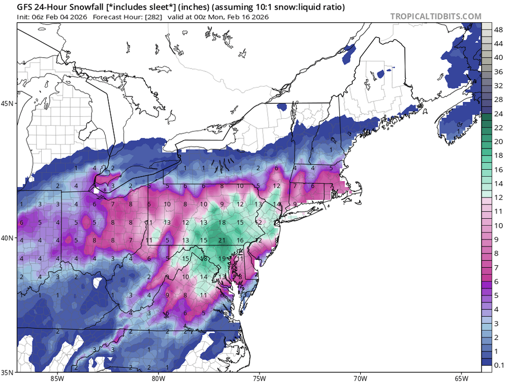
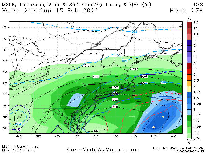
Gfs is about to show a nice coastal for February 15
-
Gfs is about to show a nice coastal for February 15
-
In Westfield, West side of the "city" about 3 miles from Baystate Nobile Hospital. In Simsbury, north side of town along RT 10
-

Central PA Winter 25/26 Discussion and Obs
Voyager replied to MAG5035's topic in Upstate New York/Pennsylvania
22 this morning here. I can handle winter morning temps in this range. Single digits to near zero, not so much. -

February 2026 Medium/ Long Range Discussion: Buckle Up!
CAPE replied to Weather Will's topic in Mid Atlantic
-

WxUSAF's weak ass frontal passage thing.
RevWarReenactor replied to dailylurker's topic in Mid Atlantic
Great event got nothing -
GFS last 4 runs, likes I40 in and around to Greensboro area...
.gif.1b5256ab45918640a7acf63541b13e71.gif)
-
It really does feel like winter is off to a strong start, but sometimes a cold and quiet start to February can end up being the precursor to an even more active pattern down the stretch of the month once the jet stream is able to get more active and the moisture can finally make its return; I saw the name Bnlboston Limo referenced in a travel article and it reminded me of how weather talk can pop up in the most unexpected of places, which goes to show just how unpredictable the patterns can be during this time of the year, and as we have seen in the past, late February shifts have brought storms even when early indications are pointing towards a dry outcome, so I am cautiously anticipating a greater degree of changeability as opposed to an early spring lock-in. What long-range indicators are you paying attention to that have you leaning one way or the other?
-

February 2026 Medium/ Long Range Discussion: Buckle Up!
mitchnick replied to Weather Will's topic in Mid Atlantic
Next weekend is the classic end of pattern threat. Coincidentally, PD1 was and the pattern not only ended, but winter itself after it. Gimme another PD1, and I can deal with winter ending knowing we have a Niño next year. - Today
-
Lake Erie is largely frozen over which may reduce the amount of decaying squall activity reaching w MD for rejuvenation, but the flow seems due northerly more from a Lake Ontario fetch anyway at least over e MD. I can't see this dropping more than 0.1" or 0.2" at airports and population centers, maybe an inch or two in higher areas to the west. Could be brief moderate snow conditions during fropa which looks to be around 0200-0400 Saturday. Monday 9th looks a bit more promising for small amounts of snow.
-
Predict the cold contest (for Feb 7-9)
wxallannj replied to Roger Smith's topic in New York City Metro
Max 21 min 8 Snow: 0.2" -

February 2026 Medium/ Long Range Discussion: Buckle Up!
Ji replied to Weather Will's topic in Mid Atlantic
The data got colder for our storm window00z 12z -
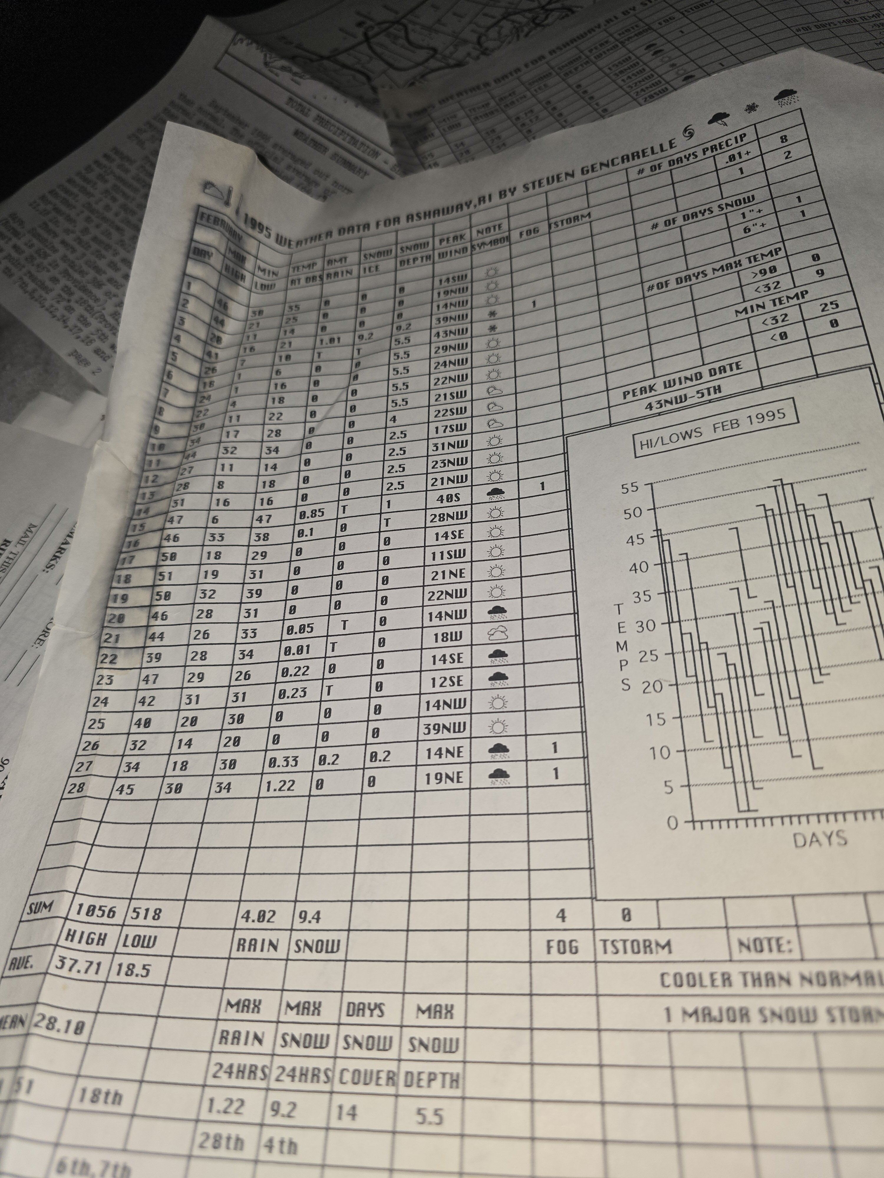
Jan 94 I was- 8BN with 23 inches of snow with a wicked ice storm
-

February 2026 Medium/ Long Range Discussion: Buckle Up!
Stormchaserchuck1 replied to Weather Will's topic in Mid Atlantic
You misrepresent things quite often. I get excited about weather, and let some of that excitement come through on the board, hoping to be like a bright light sometimes. I have been very optimistic on this Winter, from the start. I think there was one period in December where the pattern was bad but I predicted the 11" snowstorm well in advance.. remember you were even asking me, if not la nina and el nino then when, and I responded that although nothing was currently showing on models, we will probably be at average snowfall after the next few weeks, this la nina was/is not a "dead pattern".. and here we are. Besides that, it's unbelievable and childish that everything is about someone's bias.. so many extraverts on this board communicate like that. like you can only think in blacks and whites. Nevermind that there is actually a weather forecast being made. I should not get a "doom and gloom" bias from being down on snow over the last several Winters. We have been below average and like 90% of the storms I get right! If model shows snow 5-7 days out, I say too warm or rain, and it rains, that's not a bias! I agree that next Winter is not a definite good year, this Winters ridge in the Rockies and West coast is concerning to me. When we get a warm pattern some future Winter, it could torch. That's not a "doom and gloom bias", Im discussing the science of the situation. Patterns in the west lead us by time, sometimes years. History also says that this Winters pattern of cold NE/warm SW is likely to continue through March, and even Apr-Aug to some extent. I just made a post in ENSO thread about it. We may still have some opportunities this Winter. -
Nothing here Temps rise to 31 Pre treatment rds waste Need the rain next weekend to wash this crap off the rds
-
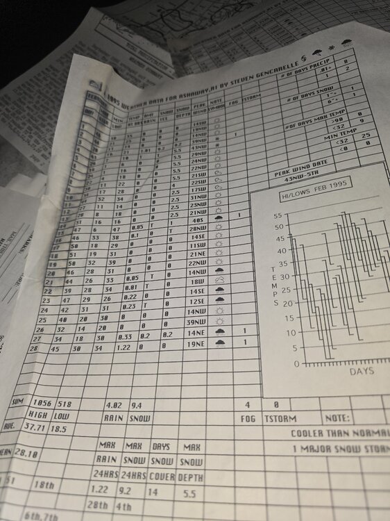
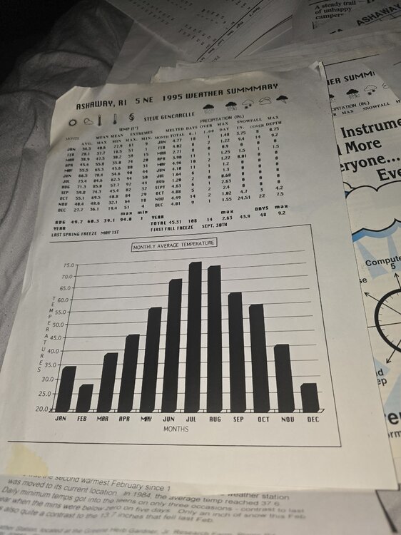
1 more Feb 1995 and the year summary you know why SRI sucks for snow. Although Dec 95 was awesome
-
 I suppose it’s possible…the more I read, apparently this place is a bit of a rad pit and has fell into the 30s multiple times in recent years. So my guess is that if this station is legit, it’s probably not very old and it probably is more common than you’d think to see 0C there.
 -
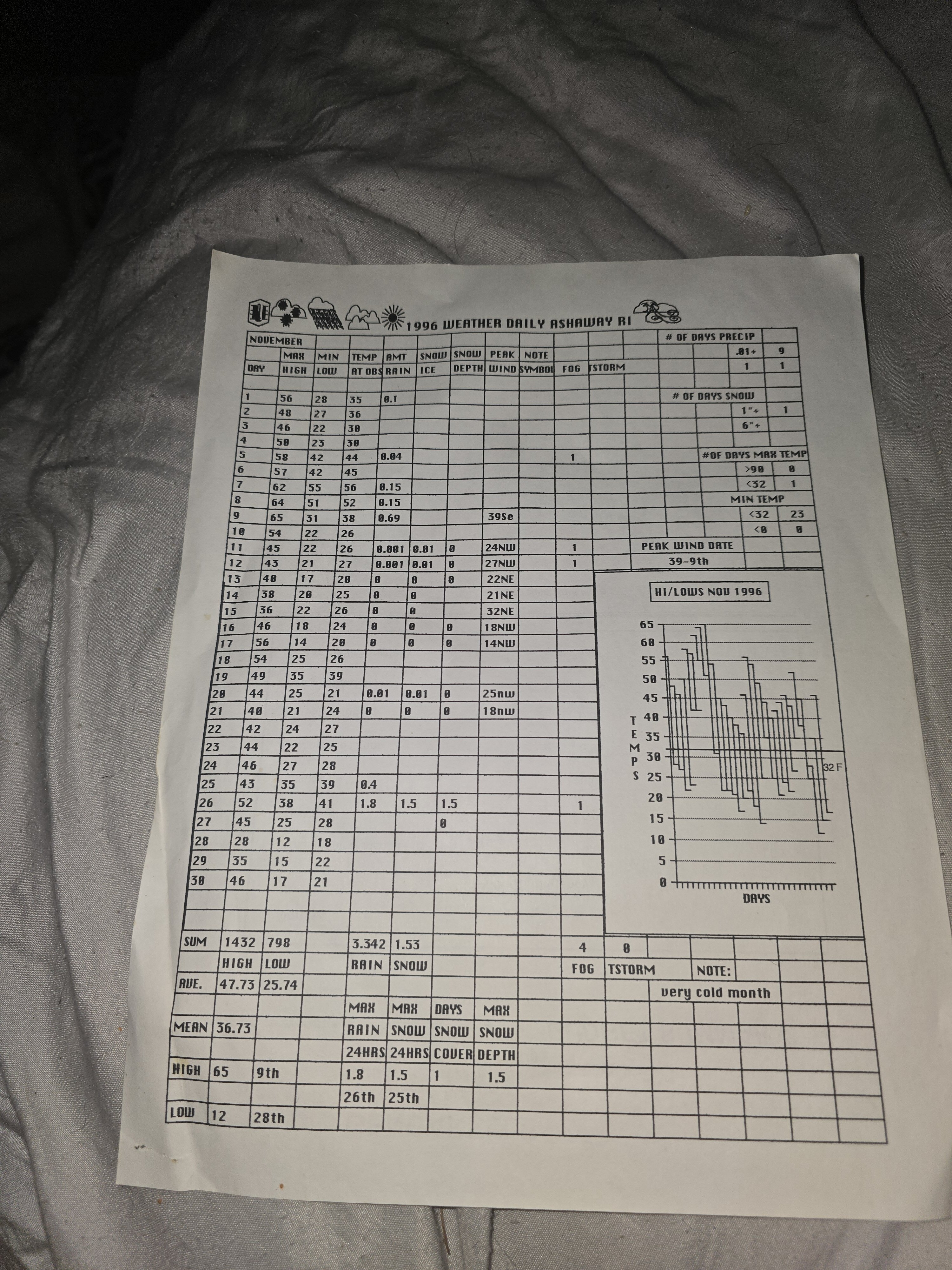
I looked hard but NADA. I have a couple of newsletters but summer editions. Literally hundreds of observers from RI Conn Mass. This was the form I used
-

Friday February 6 FROPA / WINDEX small event
WinterWolf replied to HoarfrostHubb's topic in New England
This is the year for us to pull something like that off lol….even 20:1 is a couple inches.