All Activity
- Past hour
-

September 2025 OBS-Discussion centered NYC subforum
SACRUS replied to wdrag's topic in New York City Metro
Highs: EWR: 94 (2016) NYC: 93 (1931) LGA: 92 (2016) JFK: 89 (1995) Lows: EWR: 45 (1975) NYC: 45 (1975) LGA: 48 (1975) JFK: 48 (1975) Historical: 1824: A hurricane storm surge swept over the islands of the Georgia coast with a great loss of life, destruction of crops, and severe floods inland. (Ref. Wilson Wx. History) 1912: Hurricane makes landfall just west of Mobile, Alabama. (Ref. AccWeather Weather History) 1919: 357 people died as a hurricane made landfall near Corpus Christi, TX. A 16 foot storm surge inundated the low-lying areas, destroying almost all of the wooden buildings. Port Aransas was almost totally demolished. Damage totaled $20.3 million dollars. (Ref. Wilson Wx. History) 1928: A violent, estimated F4 tornado, with winds of 200 mph, tore across Rockford, Illinois. The tornado first touched down 8 miles south-southwest of Rockford and moved across the southeast part of the city. The tornado was on the ground for 25 miles with a width varying from 200 to 500 feet. A total of 14 people were killed, with around 100 injuries reported in Rockford alone. Two hundred buildings were damaged or destroyed. 1937 - The mercury soared to 92 degrees at Seattle, WA, a record for September. (The Weather Channel) 1944 - A very destructive hurricane swept across Cape Hatteras and Chesapeake Bay, side swiped New Jersey and Long Island, and crossed southeastern Massachusetts. The hurricane killed more than four hundred persons, mainly at sea. The hurricane destroyed the Atlantic City NJ boardwalk. (David Ludlum) (The Weather Channel) 1960: Hurricane Ethel developed rapidly in the central Gulf of Mexico early on this date, intensified and moved northward with winds estimated as high as 130 mph near the center late on this date. Ethel went from a tropical storm to briefly a Category 5 within 18 hours. Ethel decreased in intensity rapidly before reaching the coast near the Alabama- Mississippi border on the 15th as a minimal hurricane. Hurricane force winds were reported in Plaquemines Parish, Louisiana, including Venice which reported sustained winds of 90 mph and gusts of up to 105 mph. Rainfall totals ranged from 2 to 10 inches. Damage was estimated at $1 million dollars and no fatalities were reported. Despite attaining Category 5 intensity, Ethel name was not retired. (Ref. Wilson Wx. History) 1970 - The temperature at Fremont, OR, dipped to 2 above zero to equal the state record for September set on the 24th in 1926. (The Weather Channel) 1971: A strong ridge was in place across the west giving very high temperature included: Palm Springs, CA: 114°, Phoenix, AZ: 109°, Victorville, CA: 108°, Fresno, CA: 105°, Stockton, CA: 104°, Sacramento, CA: 103°, San Francisco (Airport), CA: 103°, Santa Ana, CA: 100°, Bishop, CA: 100°, Downtown Los Angeles, CA: 97°, Winslow, AZ: 95 °F. (Ref. Wilson Wx. History) 1977: Severe thunderstorms produced several tornadoes in eastern Arkansas, killing one. 1982: Beginning the previous day, heavy early season snow blanketed parts of the northern Rockies. Totals included Red Lodge, MT: 36 inches, Mystic Lake, MT: 30 inches, Nye, MT: 15 inches, Sheridan, WY: 7 inches, Billings, MT: 6 inches and Joliet/Columbus, MT: 4 inches. (Ref. Wilson Wx. History) 1984: A lightning bolt struck a soccer field in West Goshen Township, PA. 26 people were injured and 4 hospitalized, including players, coaches, officials, and spectators. One of the hospitalized died 5 days later. (Ref. AccWeather Weather History) 1987 - Barrow, AK, received 5.1 inches of snow, a record for September. (Sandra and TI Richard Sanders - 1987) 1987 - Thunderstorms developing along a cold front produced severe weather from Minnesota to Texas. Thunderstorms in Iowa produced baseball size hail at Laporte City, and 80 mph winds at Laurens. Hail caused more than ten million dollars damage to crops in Iowa. Thunderstorms in Missouri produced wind gusts to 75 mph at Missouri City and Kansas City. A thunderstorm in Texas deluged the town of Fairlie with two inches of rain in just two hours. (Storm Data) (The National Weather Summary) 1988 - Hurricane Gilbert made the first of its two landfalls on Mexico, producing 170 mph winds at Cozumel. (The Weather Channel) 1988 - Thunderstorms produced severe weather over the Texas panhandle during the evening hours. One thunderstorm spawned a strong (F-2) tornado in the southwest part of Amarillo, and deluged the area with five inches of rain. The heavy rain left roads under as much as five feet of water, and left Lawrence Lake a mile out of its banks. Hurricane Gilbert lost some of its punch crossing the Yucatan Peninsula of Mexico. Its maximum winds diminished to 120 mph. (The National Weather Summary) (Storm Data) 1989 - Unseasonably cool weather prevailed across the south central U.S. Eight cities reported record low temperatures for the date, including Raton NM with a reading of 30 degrees. The afternoon high of 59 degrees at Topeka KS marked their third straight record cool maximum temperature. Unseasonably warm weather continued in the Pacific Northwest. Seattle WA reported a record eight days in a row of 80 degree weather in September. (Storm Data) (The National Weather Summary) 1992: A record early season snowstorm came to and end over the western Tanana Valley in central Alaska. 16.7 inches of snow fell at Fairbanks which set a new record for the greatest September snowstorm on record. Denali National Park was buried under 37.6 inches over the four day period and Eielson Air Force Base checked in with 23.5 inches. Along with the snow came record lows across parts of the state including: Barrow, AK: 13°, Delta Junction, AK: 23°, Nome, AK: 24°, Juneau, AK: 32°-Tied and Annette, AK: 38°. (Ref. Wilson Wx. History) 1993: Canadian high pressure behind a strong cold front brought record chill to parts of the central U.S. Some low temperatures included: Camp Crook, SD: 19°, Porcupine, SD: 19°, Rapid City, SD: 24°, Sheridan, WY: 24°, Colorado Springs, CO: 28°, Cheyenne, WY: 29°, Pierre, SD: 31°, Goodland, KS: 31°, Pueblo, CO: 31°, Denver, CO: 32 °F. (Ref. Wilson Wx. History) 1997: A powerful thunderstorm unleashed a destructive wind that wreaked havoc on a small section of Bullhead City, AZ. The fierce wind snapped 24 power poles and damaged approximately 80 houses and mobile homes. 22 of the homes were condemned. (Ref. Wilson Wx. History) 1999: A powerful thunderstorm unleashed a destructive wind that wreaked havoc on a small section of Bullhead City, AZ. The largest peacetime evacuation in United States history was underway as 2.6 million residents of Florida, Georgia and the Carolinas were fleeing in advance of monstrous Hurricane Floyd. By days end, the Category 4 hurricane was battering the northern Bahamas packing winds of 135 mph with a minimum central pressure of 934 millibars or 27.58 inches of mercury. 1999: Drought emergencies and restrictions were lifted in NJ, from Burlington to Ocean Counties and to the S, after increasing rain ended a growing season drought that caused 80 million dollars in agricultural damage. Two days later the unprecedented rains of tropical storm Floyd effectively ended the drought, as up to 14.5" of rain fell, or about 4 months worth of normal rainfall.(Ref. Wilson Wx. History) 2005: Hurricane Ophelia caused some damage and beach erosion along the United States coastline from Florida to North Carolina. The closest approach occurred on September 14 and 15 with its western eyewall crossing land and the eye remaining just offshore in the Carolinas. Click HERE for more information from the NWS Office in Charleston, South Carolina. 2008: Hurricane Ike became extratropical on this day. The St. Louis Metropolitan Area experienced hurricane conditions, with Ike's remnants inflicting severe damage to homes. Several areas in Illinois and Indiana, already flooded by the frontal boundary to the north, saw significant additional rainfall. Due to flooding in Chicago, a state of emergency was declared for Cook County due to flooding of the Des Plaines River. Hurricane-force wind gusts were reported to the east of the center across parts of Kentucky, Indiana, Ohio, and Pennsylvania with significant wind damage including structural damage to buildings and trees. 2011: The remains of Hurricane Ike brought flooding rains/high winds/power losses to the St. Louis, MO, area. In Ladue, MO a woman died when lightning hit a tree and a large limb fell on her; in University City 2 people drowned while trying to move their cars to higher ground. (Ref. Weather Guide Calendar with Phenomenal Weather Events 2011 Accord Pub. 2010, USA) 2017: Irma is among the strongest Atlantic hurricanes on record based on wind speed. The major hurricane could notch more historic moments in the days ahead. Hurricane Irma is one of the most powerful hurricanes to roam the Atlantic Basin in more than a decade, and it could hit more historical benchmarks in the days ahead. Here's a rundown of Irma's notable extremes so far. Strongest Winds in Almost 12 Years Irma's maximum sustained winds have so far maxed out at 185 mph. Those winds are well above the 157 mph Category 5 threshold and are the highest registered in any Atlantic hurricane since 2005. Hurricane Wilma on Oct. 19, 2005, was the last hurricane to have maximum sustained winds reach 185 mph. Incredible #GOES16 imagery of Category 5 Hurricane #Irma with 185 mph max wind speeds. 10:36 PM - Sep 5, 2017 One of Four Hurricanes With 185+ MPH Winds The 185 mph winds also place Irma in the upper echelon of Atlantic hurricanes based on wind speed. Only three other hurricanes have had winds of 185 winds or greater, including Wilma (2005), Gilbert (1988) and Allen (1980), according to Dr. Phil Klotzbach, a tropical scientist at Colorado State University. Allen had the strongest winds of those four hurricanes, maxing out at 190 mph in early August 1980. Records that Irma set 2018: Hurricane Florence was a powerful and long-lived Cape Verde hurricane, as well as the wettest tropical cyclone on record in the Carolinas and the ninth-wettest tropical cyclone to affect the contiguous United States. The sixth named storm, third hurricane, and the first major hurricane of the 2018 Atlantic hurricane season, Florence originated from a strong tropical wave that emerged off the west coast of Africa on August 30, 2018. Steady organization resulted in the formation of a tropical depression on the next day near Cape Verde. Progressing along a steady west-northwest trajectory, the system acquired tropical storm strength on September 1, and fluctuated in strength for several days over open ocean. An unexpected bout of rapid intensification ensued on September 4– 5, culminating with Florence becoming a Category 4 major hurricane on the Saffir–Simpson scale with estimated maximum sustained winds of 130 mph - Florence A Write-Up For The Whole Storm -
Quick in and out cool shot this weekend…stronger E. Probably frost advisories for parts of ME? But yeah, after that ens/AI are fairly warm. The Op runs bring more cold shots. Not much in the way of precip over the next 10 days here.
-
September 2025 OBS-Discussion centered NYC subforum
SACRUS replied to wdrag's topic in New York City Metro
72 / 61 upper 70s - low 80s and another great day. Looks like a carbon copy on Monday for the most part. Cut off into the southeast drifts north later Tue PM - Wed with clouds SE/ESE flow and some rain. Clear out later THu pm and Fri is the warmest day of the batch and perhaps for a while. Another nice/dry weekend coming up for the 20th-21st. -
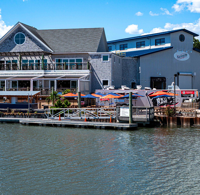
Great week for some Sea Hags at the new NEBCO. You been yet?

-
yeah I was hoping last night was going to be clear before this for telescope shots but it was not to be.
-
Torch!!
- Today
-
The eastern half of NC could get some heavy, beneficial rainfall over the next couple days depending on how strong the coastal low gets.
-
AIFS ensemble not as warm, but same theme. AN.
-
Blood red on the EPS. Wow. Zero signs of Fall.
-

2025 Lawns & Gardens Thread. Making Lawns Great Again
Brewbeer replied to Damage In Tolland's topic in New England
I'll be mowing mine after the dew dries -
Torch!
-
For JFK December was warm and wet finishing +0.9° with 4.44” of precipitation. January was near normal and dry at +0.2 and only 0.65” of precipitation. February was warm and wet finishing at +2.7 and 3.17” of precipitation.
-
Thanks, I love my South Minneapolis neighborhood. The home with the wreath on the front door is an Airbnb, directly across the street from us.
-
The time has come to admit that this is not going to be a hyperactive (ACE/named storms) Atlantic tropical season. The ship has sailed folks
-

September 2025 OBS-Discussion centered NYC subforum
bluewave replied to wdrag's topic in New York City Metro
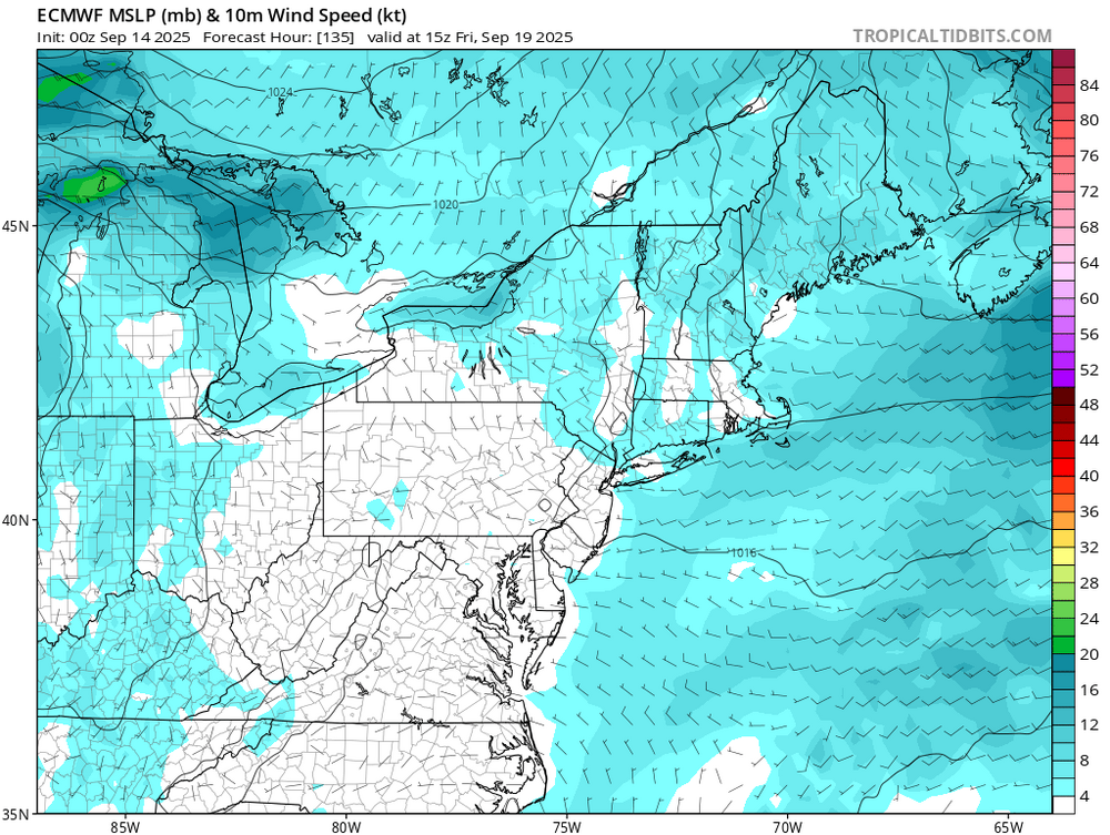
Even JFK has a shot at 85-90° next Friday as the models have a warm downslope flow now.
-
53/51 another GSD day.
-

2025 Lawns & Gardens Thread. Making Lawns Great Again
BrianW replied to Damage In Tolland's topic in New England
Nothing better than an Octoberfest and some fall mowing...
-
WPC beefing up rainfall totals with latest update.
-
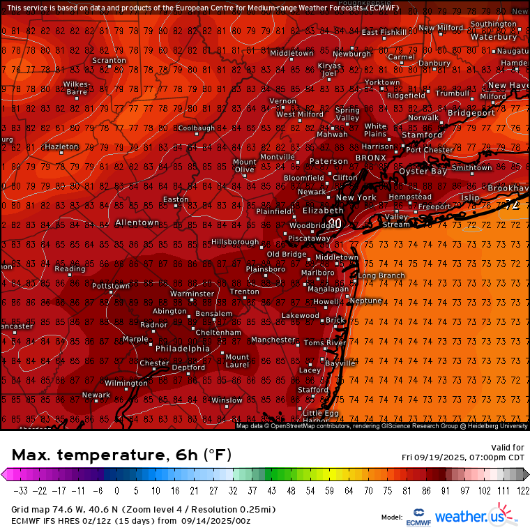
I was surprised my high was 87 yesterday, welcome back summer.
-
Looks like the Niña/-IOD standing wave has set up
-

Fall/Winter Banter - Football, Basketball, Snowball?
John1122 replied to John1122's topic in Tennessee Valley
That was a tough loss. We've not had such a painful FG miss since 2010 vs Alabama, and that one was blocked. Team looked better than I expected on offense, but man, gotta make that kick. -
Looks brutal this week.. Detailed Forecast Overnight Patchy fog after 5am. Otherwise, partly cloudy, with a low around 53. Calm wind. Sunday Patchy fog before 7am. Otherwise, mostly sunny, with a high near 76. Calm wind becoming northwest around 6 mph in the afternoon. Sunday Night Mostly clear, with a low around 51. Calm wind. Monday Sunny, with a high near 76. Light northeast wind. Monday Night Mostly clear, with a low around 50. Light and variable wind. Tuesday Sunny, with a high near 76. Light and variable wind. Tuesday Night Mostly clear, with a low around 50. Calm wind. Wednesday Mostly sunny, with a high near 76. Calm wind becoming southwest around 5 mph in the afternoon. Wednesday Night Mostly cloudy, with a low around 52. Calm wind. Thursday Partly sunny, with a high near 77. Calm wind becoming southwest around 6 mph in the afternoon. Thursday Night Partly cloudy, with a low around 55. Light south wind. Friday Sunny, with a high near 78. Northwest wind 5 to 8 mph. Friday Night Mostly clear, with a low around 48. North wind around 6 mph. Saturday Mostly sunny, with a high near 67. North wind around 7 mph.
-
For 60% orange in MDR 0Z UKMET: TS in middle of ocean again NEW TROPICAL CYCLONE FORECAST TO DEVELOP AFTER 96 HOURS FORECAST POSITION AT T+ 96 : 16.4N 45.5W LEAD CENTRAL MAXIMUM WIND VERIFYING TIME TIME POSITION PRESSURE (MB) SPEED (KNOTS) -------------- ---- -------- ------------- ------------- 1200UTC 17.09.2025 96 16.4N 45.5W 1005 41 0000UTC 18.09.2025 108 17.6N 47.7W 1005 45 1200UTC 18.09.2025 120 19.7N 49.9W 1006 44 0000UTC 19.09.2025 132 20.6N 51.6W 1006 40 1200UTC 19.09.2025 144 21.4N 53.0W 1005 36 0000UTC 20.09.2025 156 22.5N 53.5W 1004 46 1200UTC 20.09.2025 168 22.9N 55.4W 1002 45
-
That’s a pretty low bar
-
It should be a more exciting winter for most of SNE than last winter.


.thumb.png.4150b06c63a21f61052e47a612bf1818.png)