All Activity
- Past hour
-
 Indeed. Newest addition to the weenie handbook. Chapter IX, "Surface Temps on Global Models," new entry in part A.3, line 25: "global AI models are approximately 5-10 degrees too warm in DJFM"
 -

Is we back? February discussion thread
40/70 Benchmark replied to mahk_webstah's topic in New England
With PNA sliding negative it will definitely be Miller B. -
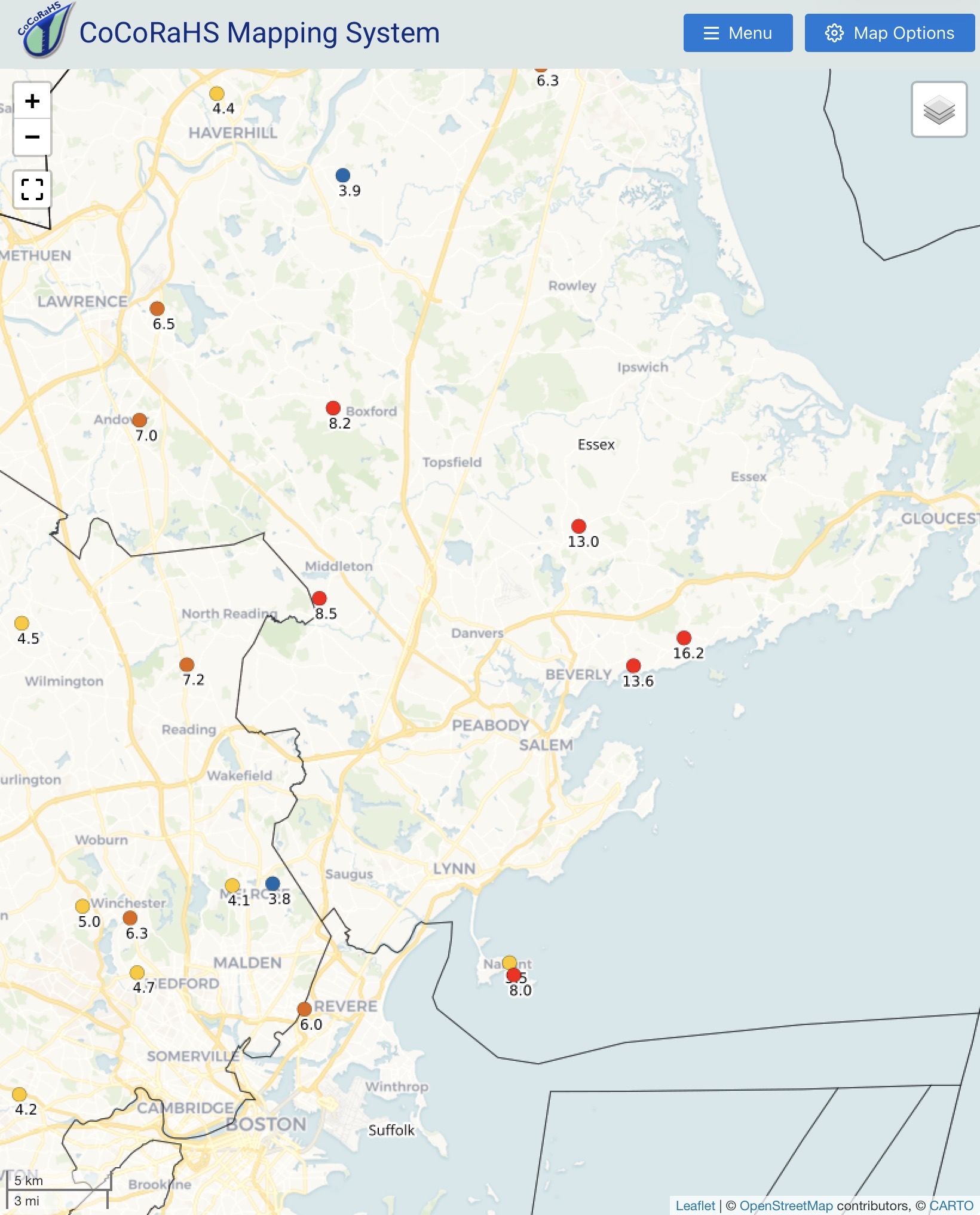
There was an mPing report near North Hills at 12:20pm. @NorthHillsWxis that you? LOL
-
 Too suppressed or too warm. It’s all about timing for these storms here lol.
 -

Feb 10-11 Mid Week Minor Event - Ride the hot hand?
HoarfrostHubb replied to HoarfrostHubb's topic in New England
NAM gives my area 3-5”. lol. -

Winter 2025-26 Short Range Discussion
roardog replied to SchaumburgStormer's topic in Lakes/Ohio Valley
Please stay in Florida. Thanks. -

February 2026 Medium/ Long Range Discussion: 150K Salary Needed to Post
TSSN+ replied to Weather Will's topic in Mid Atlantic
I think it struggles at showing surface temps. -
Winter 2025-26 Short Range Discussion
roardog replied to SchaumburgStormer's topic in Lakes/Ohio Valley
I mean if you're in some rural white trash trailer park you might have an issue but I'm sure that's true in Illinois too. Other than that, I think he's misinformed. -
Is we back? February discussion thread
40/70 Benchmark replied to mahk_webstah's topic in New England
Not nearly the same concern it would have warranted a month or two ago....."I ain't afraid of no ocean" -
Mpm give you husband phone?
-
 To be so cold for weeks and then end winter on a perfect track rainstorm would be pretty funny
 -
Is we back? February discussion thread
40/70 Benchmark replied to mahk_webstah's topic in New England
PDIII LFG!!!! -
-2° for the low this morning
-

Friday February 6 FROPA / WINDEX small event
dendrite replied to HoarfrostHubb's topic in New England
The w.e. checks out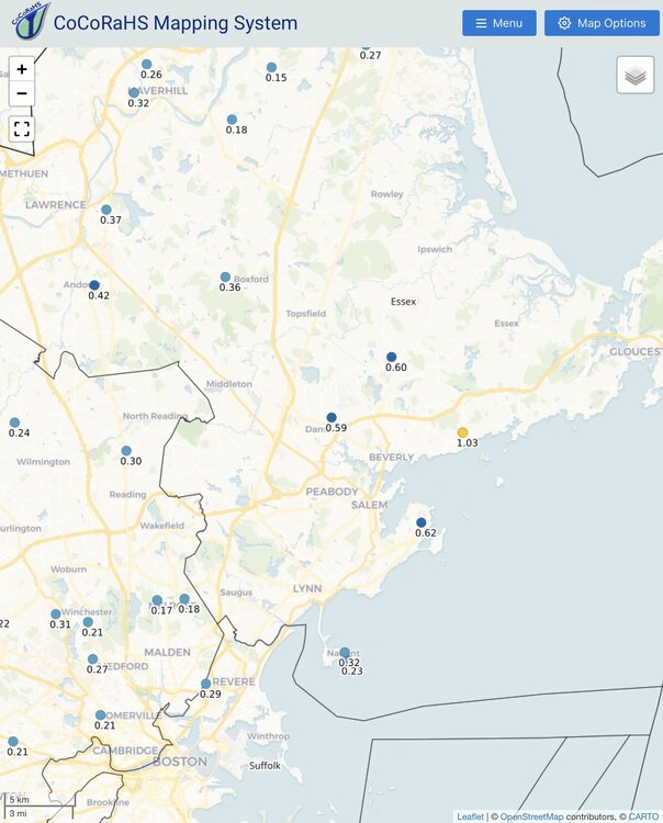

-
I think the storm next weekend is real. Not atypical to have a storm as the transition event towards a warmer pattern.
-
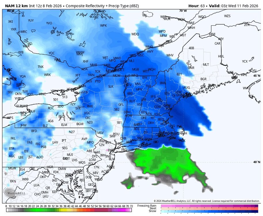
 12z euro ai has a good track only problem is the freezing line way north of Montreal lol
 -
 That’s damn impressive . This winter is legit
 -
 It will be in the Carolinas soon enough if that continues.. Wahh wahhh
-

Winter 2025-26 Medium/Long Range Discussion
DocATL replied to michsnowfreak's topic in Lakes/Ohio Valley
Virginia is for snow lovers. -
Feb 10-11 Mid Week Minor Event - Ride the hot hand?
Damage In Tolland replied to HoarfrostHubb's topic in New England
-

Winter Storm Threat *Technical* Discussion. No Op Run PBP or Snow maps
CAPE replied to CAPE's topic in Mid Atlantic
-

Winter Storm Threat *Technical* Discussion. No Op Run PBP or Snow maps
psuhoffman replied to CAPE's topic in Mid Atlantic
Is it possible that for once “what could go right” happens instead of…what we’re used to -
And if the storm trends more amped, there is nothing in its way to stop it from advancing as far north as possible. We need cold air reinforcement in order to do well in a setup like this.
-

Winter Storm Threat *Technical* Discussion. No Op Run PBP or Snow maps
SnowenOutThere replied to CAPE's topic in Mid Atlantic
Honestly with 12z I'm not even sure if you could call the bit of low pressure in the Ohio valley a primary. From how I'm seeing the setup it appears to be an extension of the main low pressure system across the southeast states. -
Friday February 6 FROPA / WINDEX small event
dendrite replied to HoarfrostHubb's topic in New England
They were pounding when all of those 10-12” reports came out yesterday mid morning. I honestly expected to see more 15-18” obs. Those who cleared probably did, those who let it set probably stuck around that 12-13” mark.