All Activity
- Past hour
-
 legit mexican pharmacy: Mex Get Rx - pharmacia mexico
 -
It seems like they bumped up Friday's foretasted temps higher to the mid 70s now...might be the last shot in the city for a while or the rest of the year. Does anyone have a handle on Friday's storms yet? So far it's looking like showers in the morning, a dry midday, and a possible line of storms in the late afternoon/evening but I'm not sure if I'm interpreting the models correctly.
-
https://indigetrx.shop/# buy drugs from india
-
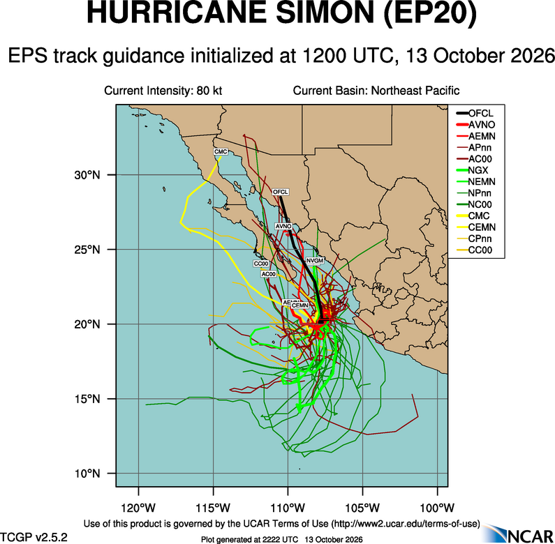
Newly formed Trudy is fcst to become quite intense. Trudy as name rang a bell for me since this was also an intense Oct hurricane (135 kt) in 1990. and hung around for two weeks. https://en.wikipedia.org/wiki/1990_Pacific_hurricane_season#Hurricane_Trudy Of the top 5 EPAC ACE prior to 2026, 1990 is #4 and that was a neutral ENSO year. In fact, of this top 5, only 2015 was very strong El Nino.
-
82 for the high. Williamsport, Altoona, and Bradford had record highs today.
-
"Squashed spider!"
-
First twenties this weekend? After we get past Friday it looks like some pretty fine weather.
-
Made into the low 50's today with 0.26" of rain yesterday in the mid 50's. Cloudy all day, but looks to be breaking up, so any clearing will allow for some colder temps tomorrow am. Seasonable wx for mid Oct.
-
91. Hopefully the end of this crap.
-
Yes, also recency bias - the cognitive shortcut that what has happening now or very recently has more significance/importance than what was prior. When you look at wx history and all regions of the world, you can find numerous focused regional wild periods for wx. Just for U.S. HUs? New England had 5 hurricane landfalls 1938-1960, and since 1991, none. People back then in the region would be like, "what the heck is going on?" and people now in the same region would be like "what's a hurricane?" FL is nothing new to wild periods: Hit by 5 category 4 hurricanes 1945-1950, 12 hurricanes 1941-50 w/ 6 major, and a record 13 landfalling hurricanes 1871-80. Or more general: From 1926-1969, 14 category 4/5 hurricanes had U.S. landfalls. For the period 1970-2016, only 4 category 4/5 hurricanes had U.S. landfalls. The 14 yr period 2006-19 had 3 CONUS major hurricane landfalls. This is the least for such a period since 1900. The most is 13 from 1915-28. In June 1886, 3 hurricanes made landfall in the U.S. No other June has had more than 1. The last June CONUS hurricane landfall was in 1986. This is the longest stretch w/o a June CONUS landfall on record.
-
https://indigetrx.com/# generic medicine buy online
-
My family is from Norfolk and I grew up there as well. My father was 8 in 1938. The flooding was the really big issue - he would tell us stories of him and his 6 brothers along with their mother wading through the flooded Blackberry river with his mother threatening them to an ounce of their lives that they had to hold hands as tight as possible to get through the water. I believe the hillsides were pretty denuded from the charcoal industry and farming - I don't believe '38 took huge stands of trees in Norfolk. I have seen photos from relatives earlier than 1938 that show the hillsides as pasture with sheep grazing on Haystack Mountain.
-
Why is LWX forecasting in knots over land??? A potent shortwave trough will approach from the Great Lakes on Friday. A strong area of low pressure will form just downstream of this trough and track northeastward into the St. Lawrence Valley over the course of the day. Southerly flow ahead of the system will advect an unseasonably warm and humid airmass northward into the area, with temperatures forecast to climb into the 80s and dewpoints reaching into the 60s. The system`s cold front will move through the area Friday afternoon into Friday evening. The front will move into an environment with around 500-1000 J/kg of instability, so a line of thunderstorms may ultimately form along the front. If thunderstorms were to form, they may be capable of producing damaging winds, given the strong winds that will be in place just above the surface (around 40-45 knots at 850 hPa). Regardless of whether storms form or not, strong northwesterly winds are expected behind the system`s cold front late Friday through Friday night and into early Saturday morning. Frequent gusts of 30-40 knots appear likely across the area in northwesterly flow, and some locations may even see some gusts above 40 knots. The Alleghenies and Blue Ridge appear to be the most likely locations to reach Wind Advisory criteria of 40 knots.
- Today
-
Halloween 1987 the upstate saw snow flurries. Walked out of the house that morning and small flakes were falling. Didn’t last long but pretty cool.
-
People think we joke when we say we want whole forests/ hillsides blown down. It has happened and will soon
-

Mountain West Discussion
mayjawintastawm replied to mayjawintastawm's topic in Central/Western States
12Z models are still split about this storm, with QPF over an inch from GFS, ECMWF and their ensembles, much less from the NAM and Canadian (0.25-0.4"). NWS point and click for me is 0.56". We shall see. -
My daughter has a 10AM soccer game in Burlington Sat..oye.
-
Twenty years of the NAM was like having a crazy uncle in the room every time a storm threatened Harrisburg. Half the time it was off in its own universe NAMMING the LSV with a 30-inch fantasy, or drawing a snow/sleet gradient through Cumberland County so tight you could practically cross it walking down the street. March 2015 was vintage NAM: a run trying to dump 2–3 inches of sleet over parts of the LSV while taking snowfall from 12 inches to 2 inches in roughly 10 miles. Then came January 2016. While the Euro and GFS wandered around, the NAM kept hammering away at the same outrageous solution, the SREF had a camp increasingly interested in the bigger totals, and the 700–500 mb frontogenesis actually provided a physical reason to take it seriously. KMDT finished with 30.2 inches, with 36.9 inches reported at either Carlisle Mechanicsburg. That doesn't mean every crazy NAM map verified, but that storm is why you could never completely dismiss the damn thing. although it was great here in 2016 it's greatest coup in history had to be New York City Central Park same storm where 12 hours before you had the euro and the GFS adamant that Central Park would see no more than 12 in and the man was there drunk giving them the finger saying eat this with his 26". 24 hours later Central Park with register 27.5 in breaking their all-time record and forever cementing NAM in lore and more than making up for being burned by it the year prior. although I do feel bad for the Mid-Atlantic people maybe it's fitting poetry that it saves is absolute most let yourself on fire bad calls for that area the most. who forgets who could forget the famous March 6th 2013 10-in call with borderline crappy thermals. yes everyone knows not to trust in them but it was so adamant that so when you got their hopes up as I continue to print out 6 in of snow when it was nothing but sleet and rain. the name did everything and it's power to put some life and craziness into this hobby and a certain as it was it'd be too far north with the precipitation shield you knew that it was either going to have the one of the greatest groups ever or one of the greatest bust ever it was never not entertaining. That is why even though it might spend months going down in flames we still paid attention because at heart it was the biggest weather weenie model of them all. Cheers to your retirement you big doofaus. maybe just maybe it's 3 weeks until able to give it just enough time to have one last crazy ending by November 3rd, as it just 15 years ago on October 29th we had Jim cantore thunder snow whiteouts and 5.5 in on 1.4 in of precipitation with a high of 42. About as much as his nam storm as you're going to ever get. That was the only the second time we ever exceeded 3 in of snow by November 3rd. the first time was during the absolute most freakish 4 years of snow this area has ever seen November 3rd 1962. Sent from my SM-S731U using Tapatalk
-
Must be a site to behold. Cat 3’s (that are moving at 50 mph) will do that.
-
Crunchy leaves for Halloween, woohoo!!! Way better than snow. Growing season is about done anyway. So I cant say I mind some dry weather to finish fall projects. There's always December and January for cold rain.
-
And so it begins….
-
Hoovered in the upper 40's to around 50 all day with off and on mist. Starting to look more like winter than fall. Wouldn't be surprised to see some wet snow mix in with the rain in the higher terrain late week but it will be brief if at all.
-

October 2026 general discussion
Prismshine Productions replied to Typhoon Tip's topic in New England
No Sent from my SM-S176V using Tapatalk -

2026-2027 Record-breaking El Nino
LakePaste25 replied to Stormchaserchuck1's topic in Weather Forecasting and Discussion
+EAMT beginning to show up in the models towards the end of october with high SLP east of the Himalayas. Watch out for a jet extension and +PNA after. -
Looks like Christmas day