All Activity
- Past hour
-
 looks like a mix of 1966, 1978, 1993 and 2003
 -
Debated if this is banter or obs, but it's wild to me that about 2 weeks after the storm you can still look at the Maryland Highway traffic cameras and see snow on the ground for most of the state. That does not happen very often here.
-

Is we back? February discussion thread
Damage In Tolland replied to mahk_webstah's topic in New England
1-3” ?? Looks like a nice high end advisory as of now like Scoots said -

2025-2026 ENSO
Violentweatherfan replied to 40/70 Benchmark's topic in Weather Forecasting and Discussion
He also pointed out how off the forecast was for the MJO. It’s definitely going in the wrong direction so here is to hoping if is off about that. -
mm hm. Sure is. The flow is in torpedo mode. So a 'few inches' whenever/wherever it occurs might be considered more of an achievement - relative to faster flow limitations. The western ridge refuses to gain latitudinal arc in the ongoing verification, and that's been/is keeping a modestly compressed, slightly faster than normal field, thus preferentially progressive. Those former two aspects are constructively interfering such that S/Ws move from circa IA clear NE of Nova Scotia in 36 hours.. What is that, 1 and 1/2 times faster than climate trajectories? I bet you we could create like an index finger rule, similar to the 1kt = 1mb, only for S/W vs output. 1::1 like that... for every 10% a S/W is moving faster than climo, that's 10% reduction in productivity. -10%, and it adds because that means the system slowed down and donut stuffed a region like Homer Simpson in hell ... who of course encounters Ned Flanders as the devil...
-
(002).thumb.png.6e3d9d46bca5fe41aab7a74871dd8af8.png)
Central PA Winter 25/26 Discussion and Obs
ChescoWx replied to MAG5035's topic in Upstate New York/Pennsylvania
Our coldest weather of the year is on the way over this weekend. Snow showers should begin from west to east across the area this evening with occasional snow showers and maybe a snow squall tomorrow morning. The high tomorrow will be overnight tonight but quickly fall into the single digits above zero during the day tomorrow with winds gusting as high as 50mph. The extreme cold warning goes into effect at 3pm tomorrow. Snow amounts will be light with between a coating and an inch at most. We should finally warm up to near freezing by Tuesday with a chance for some freezing rain or rain by Wednesday with temperatures just above freezing in most spots.
-

E PA/NJ/DE Winter 2025-26 Obs/Discussion
The Iceman replied to LVblizzard's topic in Philadelphia Region
AI EPS still likes the 15-17th period.. if you are referring to the 11-12th, that's another northern stream clipper that changes every 6 hours... it's going to change every 6 hours.. -
E PA/NJ/DE Winter 2025-26 Obs/Discussion
ChescoWx replied to LVblizzard's topic in Philadelphia Region
Our coldest weather of the year is on the way over this weekend. Snow showers should begin from west to east across the area this evening with occasional snow showers and maybe a snow squall tomorrow morning. The high tomorrow will be overnight tonight but quickly fall into the single digits above zero during the day tomorrow with winds gusting as high as 50mph. The extreme cold warning goes into effect at 3pm tomorrow. Snow amounts will be light with between a coating and an inch at most. We should finally warm up to near freezing by Tuesday with a chance for some freezing rain or rain by Wednesday with temperatures just above freezing in most spots.
-
Looks like 1-3" right now , could be all rain or a whiff as well..
-
 Sunday morning looks coldest in NYC metro most have seen in their lives… Once in 50 year level potential with this. 0F in CPK is conservative. The bias is to take UHI and +5 vs guidance but the in situ cold and winds will mitigate those affects. Very relieved personally that the axis of cold is about 250 miles west of here. Binghamton NY flirting with -20F before wind chill is holy shit level cold for our latitude.
 -
This post made me look closely out the window here in Hagerstown. I've seen a few mangled flakes, but this air is super dry this morning so it looks like mostly virga. Maybe those slightly better returns out west of me are doing a little better?
-
Friday February 6 FROPA / WINDEX small event
Damage In Tolland replied to HoarfrostHubb's topic in New England
Sure does ! -

Friday February 6 FROPA / WINDEX small event
ScituateWX replied to HoarfrostHubb's topic in New England
Sign me up! -
 Latest Google whatever it is model from WB's JB post. Day 10.
-
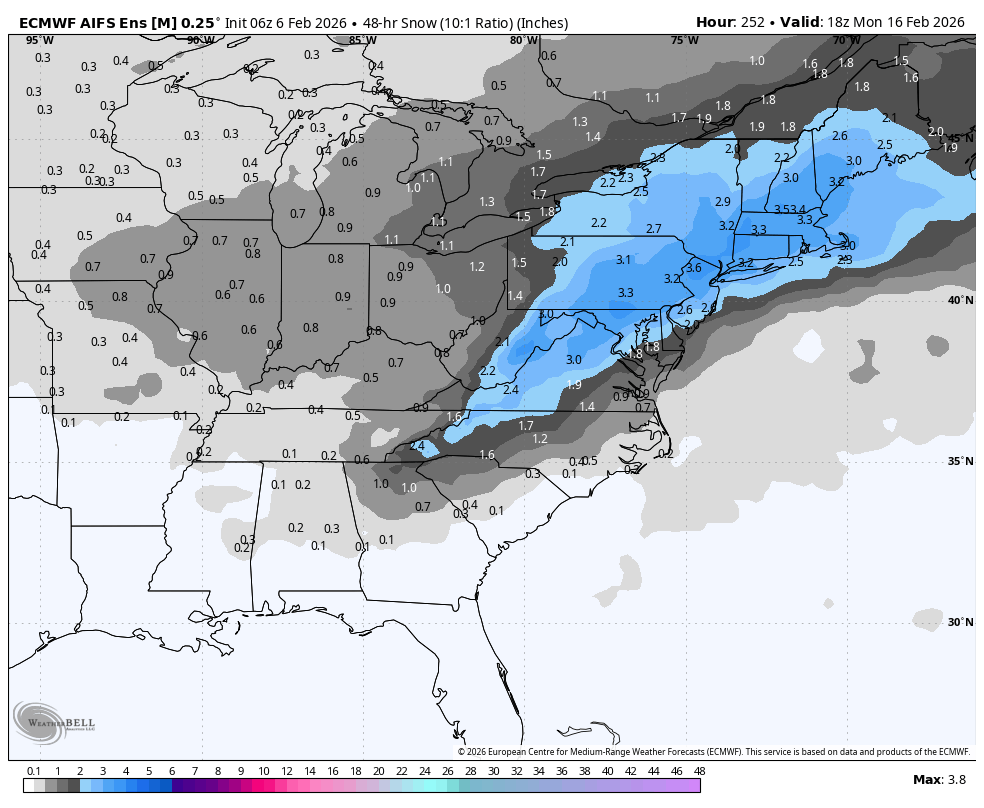
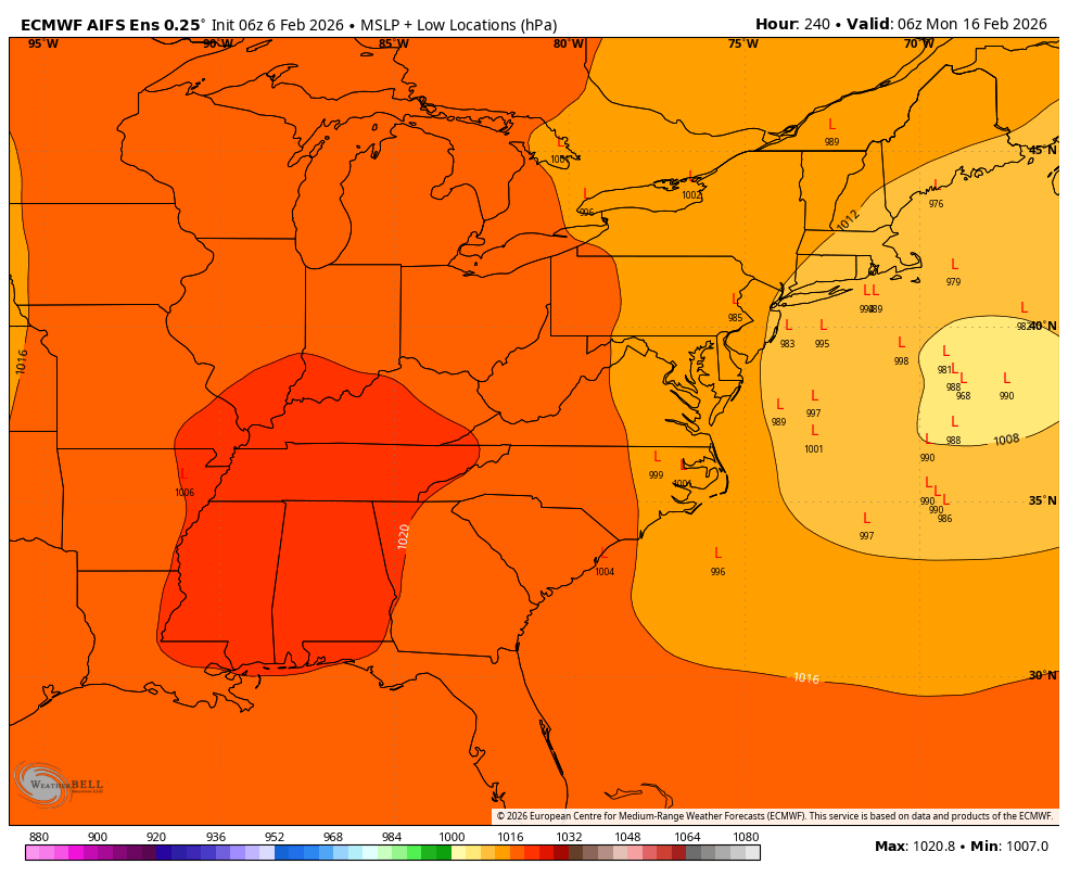
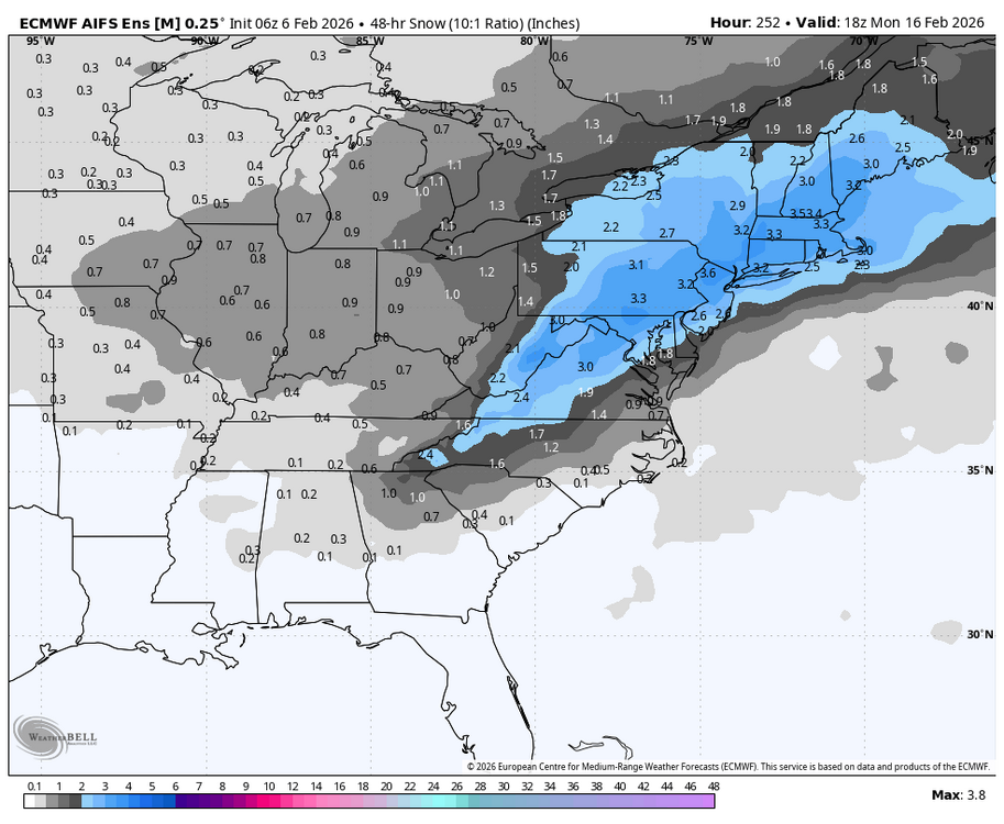
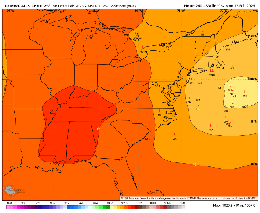
AIFS ensembles still like the 15-17..
-
Is we back? February discussion thread
Damage In Tolland replied to mahk_webstah's topic in New England
3-6/4-8 is fine . Add to pack -
@CAPE WRT AIFS ENS There are only 2 members that have any snow at all from the lead wave next week. The median snowfall from Saturday evening to Monday evening of PD weekend is about 3-4" across our area. The mean is closer to 5". The split is about 30% of the members have a VERY big storm with a classic 95 points NW MECS/HECS signature. Then there are another 20% that have something pretty decent...2-4 to 4-6" type storms...a few members have something very minor and about 40% have absolutely nothing. It was an improvement over the last 3 runs and got us back to where we were 24 hours ago when I made that post showing how "interesting" they looked. BUt yes...the total mean is inflated some. BTW, they are interested in your window too...the median spikes up another 1-3" during your period and the mean about 2-3" which is significant for that lead time
-
Plan to hike Shenandoah on my way home to nova around midday. Hopefully have some luck at 3000 ft
-
It did on 1/25…no?
-

Let’s talk winter!! Ohio and surrounding states!! 24'-25'
CoachLB replied to buckeye's topic in Lakes/Ohio Valley
Heavy snowfall probably around in inch so far. -
If a few inches is ramping up sure.. It's looking like Saturday will possibly be the highlight of February for many, can't get a storm to strengthen to our south..
-
Yeah I'm not seeing the current snow showers on the radar on any of the short range guidance, interesting to see if it hits the ground.
-
Yeah I didn’t see anything on my walk/run to class
-
All virga.
-
12z NAM is better for us in NOVA. I can't help but laugh at this forecast: Today Scattered snow showers, mainly after 1pm. Mostly cloudy, with a high near 32. Calm wind becoming south around 5 mph in the afternoon. Chance of precipitation is 50%. Tonight Scattered snow showers, mainly before 8pm. Cloudy during the early evening, then gradual clearing, with a low around 11. Wind chill values as low as -3. Blustery, with a light and variable wind becoming northwest 19 to 24 mph in the evening. Winds could gust as high as 41 mph. Chance of precipitation is 30%. Saturday Sunny, with a high near 17. Wind chill values as low as -11. Windy, with a northwest wind 29 to 32 mph, with gusts as high as 60 mph. Saturday Night Mostly clear, with a low around 9. Wind chill values as low as -8. Blustery, with a northwest wind 17 to 25 mph, with gusts as high as 41 mph. Sunday Mostly sunny, with a high near 22. Northwest wind 11 to 14 mph, with gusts as high as 26 mph. Sunday Night Mostly cloudy, with a low around 11.