All Activity
- Past hour
-
WB 6Z tracks.
-
I wouldn't look at the verbatim output seriously yet. Look at the upper level pattern.
-

September 2025 OBS-Discussion centered NYC subforum
SACRUS replied to wdrag's topic in New York City Metro
73 / 71 cloudy some light showers 0.20 in the bucket. Clouds sticking around much of the next few days with Friday the exception. Warm / humid some additional rain later today and then on Sunday. Eyes turn to Imelda and Humberto with Imelda the EC risk. Overall warm beyond the twin tropics in the 10/3 period and beyond. -

September 2025 OBS-Discussion centered NYC subforum
lee59 replied to wdrag's topic in New York City Metro
.27 inch of rain yesterday an .35 inch so far today. -

September 2025 OBS-Discussion centered NYC subforum
jm1220 replied to wdrag's topic in New York City Metro
The 2”+ amounts some models had for the city east aren’t happening outside of a lucky small swath here and there and as usual the better stuff will be NW generally. More of this again and again. -

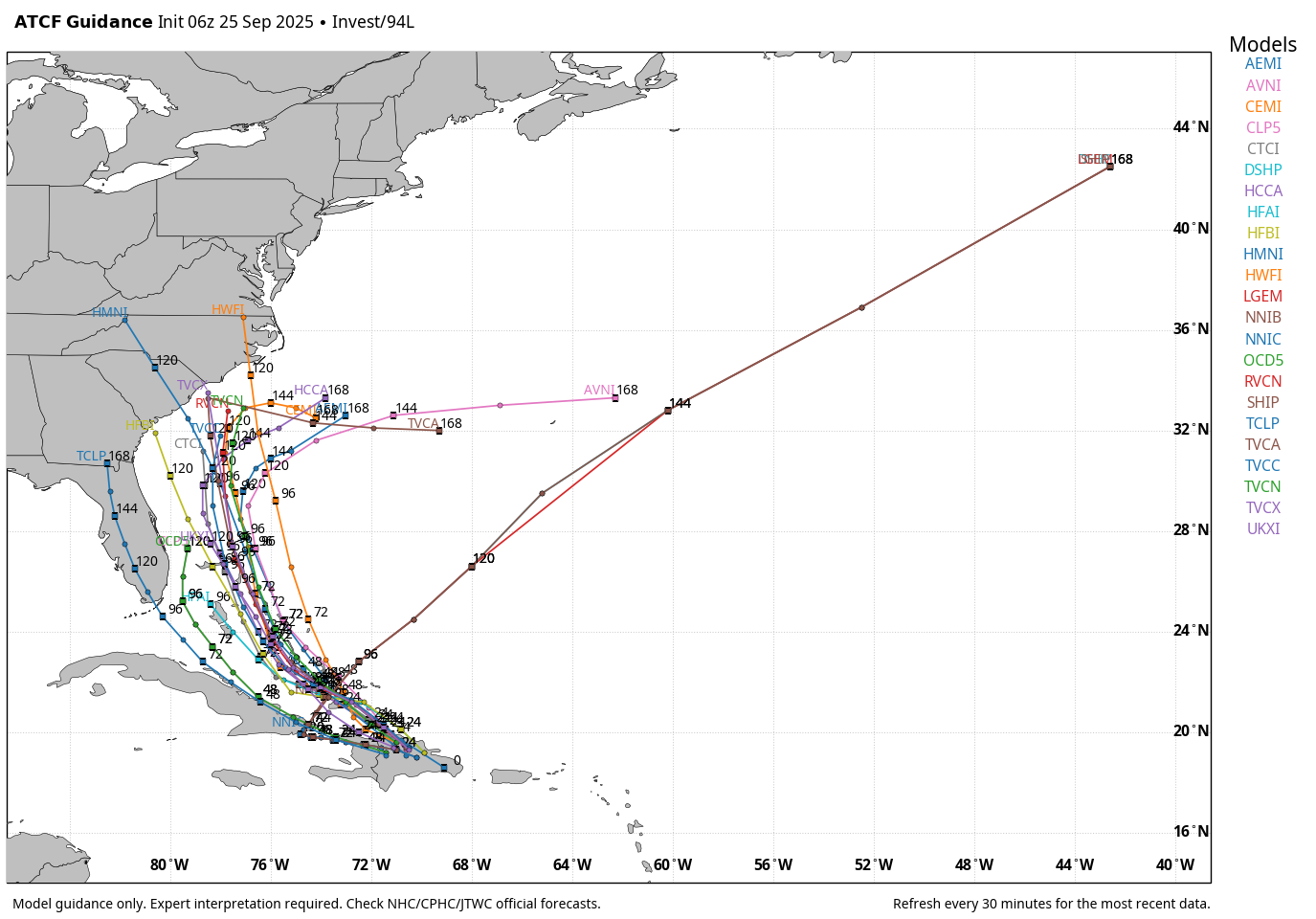
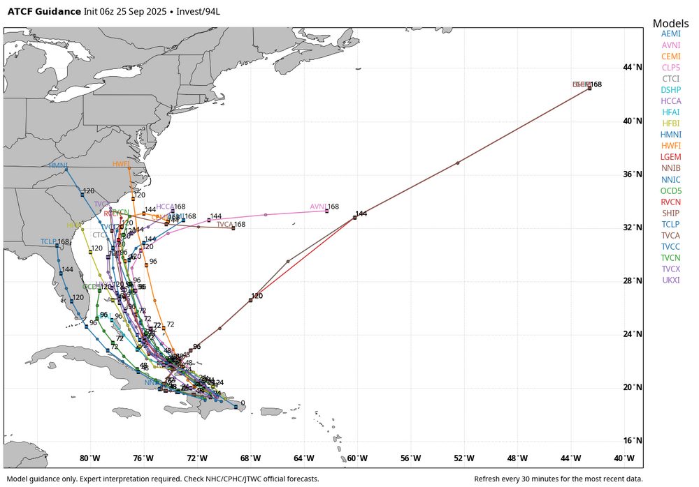
Invest 94L—70% 2 day and 90% seven day odds of development
Newman replied to WxWatcher007's topic in Tropical Headquarters
The trend in the recent GFS and Euro runs has clearly been towards a stronger HP system over the top of Humberto, which effectively allows it to strengthen faster, move slower, and travel more on a west-northwest heading vs purely northwest. This allows for greater spacing between 94L and Humberto, it "escapes" out ahead of Humberto without any real fujiwhara or interactions. Humberto plays a big role in the final evolution of 94L. How quickly 94L can develop once crossed over Hispaniola also is huge, but we don't know that yet. Until a well-defined center of circulation and system is there, there's lots of uncertainties -
For New England, this one looks gone for now for a direct strike. The only "hope" would be what the 00z Euro showed and some sort of regeneration in the long range as the ridge rolls east. Or something like the EPS this hits the Carolina coast first but continues to be dragged northward with a more robust ECONUS cutoff. Even under that scenario, idk if we see a real EC runner and obviously the further inland the weaker it becomes. Though that would probably create a big rain setup. This is absolutely a legit threat for the southeast though. Fujiwhara is rare in the Atlantic for a reason, and even though Humberto is likely to become a major you look at 94L this morning and that's not a system that's just going to get absorbed. It may very well get going quickly once it can develop a LLC on the other side of Hispaniola.
-
The EURO is backing off with the 06z run.
-
It’s nice to see GYX radar down for my first rainy day in 2 months Around 0.50” so far edit…back up
-
0.43" yesterday. Couple more hundredths overnight. Dark, wet, morning.
-

September 2025 OBS-Discussion centered NYC subforum
Sundog replied to wdrag's topic in New York City Metro
That stuff in Virginia and Maryland might clip us after watching a long radar loop on College of Dupage. It's going to be a close call. -
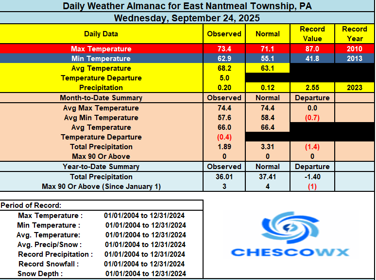
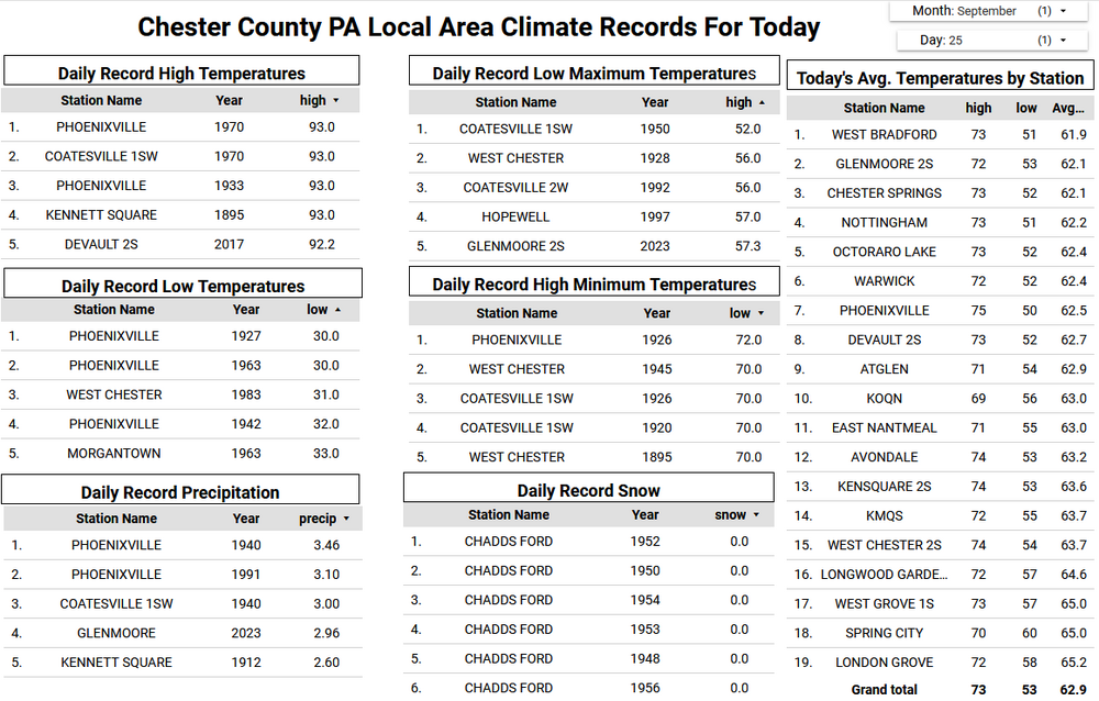
We have picked up another 0.14" since midnight bringing our 3-day rain total here in East Nantmeal to 0.77" of much needed rain. Looking downstream more rain is on the way later this morning. The NWS has a forecast potential of another 0.50" to 1.00" by later tonight. We get a break tomorrow before rain chances increase again by Saturday night. Temperatures look to remain above normal levels for the end of September, but we start to cool down by early next week and we will see highs by Wednesday in the 60's with 40's returning for morning lows by the middle of next week as we start Red October! Go Phillies!!
-
(002).thumb.png.6e3d9d46bca5fe41aab7a74871dd8af8.png)
E PA/NJ/DE Autumn 2025 Obs/Discussion
ChescoWx replied to PhiEaglesfan712's topic in Philadelphia Region
We have picked up another 0.14" since midnight bringing our 3-day rain total here in East Nantmeal to 0.77" of much needed rain. Looking downstream more rain is on the way later this morning. The NWS has a forecast potential of another 0.50" to 1.00" by later tonight. We get a break tomorrow before rain chances increase again by Saturday night. Temperatures look to remain above normal levels for the end of September, but we start to cool down by early next week and we will see highs by Wednesday in the 60's with 40's returning for morning lows by the middle of next week as we start Red October! Go Phillies!!
-
 Really thinking the odds of this affecting the SE coast are increasing. A weaker Humberto/further separation increases risk further. If Humberto wasn’t there this is going into coast. Still a lot on the table and until a center forms there isn’t a clear solution but the trend on ensembles is clear and we’re seeing ops follow suite. Everyone from northern Florida to the OBX needs to be alert
 -
Pouring in norton
-
Torrential here for last 45 minutes…
-

September 2025 OBS-Discussion centered NYC subforum
bluewave replied to wdrag's topic in New York City Metro
The new RRFS A has been maintaining that trajectory for days now with the heaviest focused to our NW. It’s still considered an experimental forecast so doesn’t really get included in the mix during forecast discussions. It could be that the warmer conditions with the record 70° lows resulted in the front stalling a little more to the NW of the very wet models like the Canadian suite focusing the max right through our area. So the stalled front would up further north than the wetter models. -
It can snow plenty here in a warm overall winter. We don’t need end to end frigid conditions. We just need the Pacific pattern to cooperate in windows of a few weeks to allow for good storm tracks while there’s half decent cold to work with. We don’t benefit from the storm track types that can still dump plenty for I-90 or even I-84.
-

September 2025 OBS-Discussion centered NYC subforum
WestBabylonWeather replied to wdrag's topic in New York City Metro
Well……it rained a little bit. -
Days and days
-
September 2025 OBS-Discussion centered NYC subforum
Sundog replied to wdrag's topic in New York City Metro
Up to a whopping 0.14 here after this last batch of scattered rain showers moved through. -

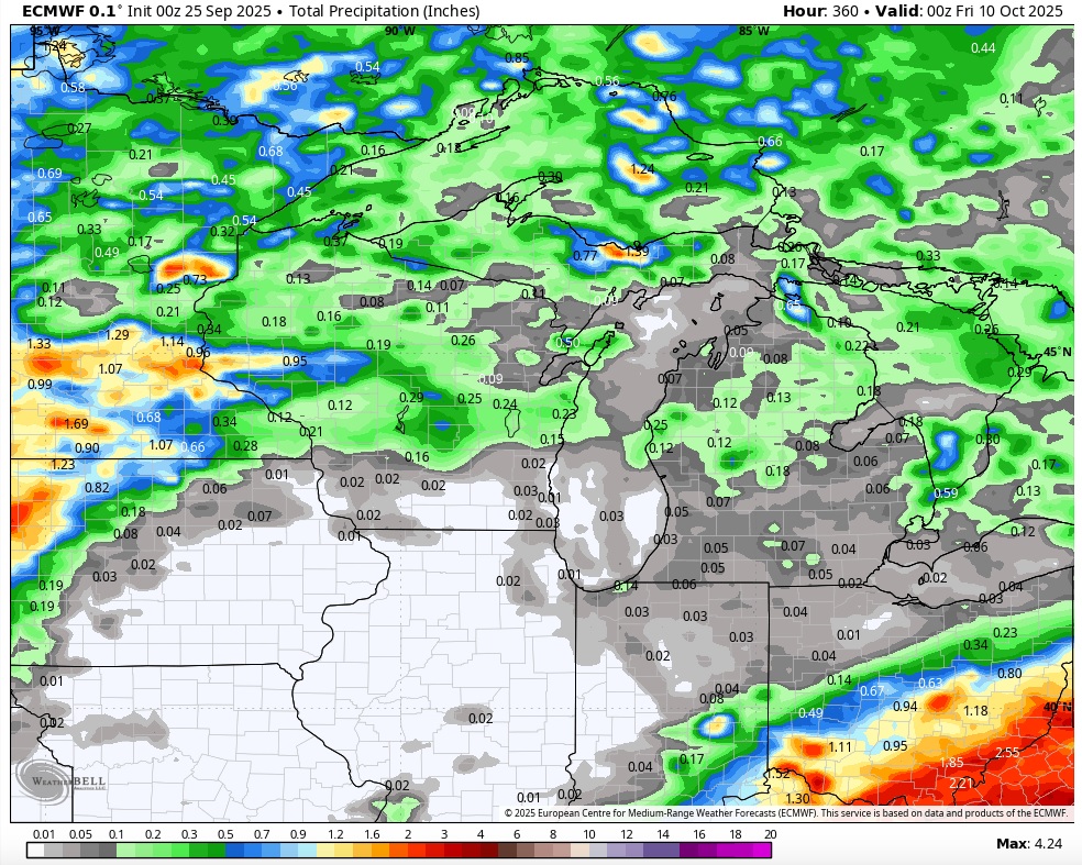
Fall 2025 Medium/Long Range Discussion
cyclone77 replied to Chicago Storm's topic in Lakes/Ohio Valley
Exciting times ahead.
-
September 2025 OBS-Discussion centered NYC subforum
Sundog replied to wdrag's topic in New York City Metro
The trajectory of the precip to our west and southwest looks like it will take it northwest of our area. I hope something else blossoms that could give everyone a nice soaking as opposed to this ultra scrattered popcorn crap. -
Comes up where?? The CTRV?
-

2025-2026 ENSO
40/70 Benchmark replied to 40/70 Benchmark's topic in Weather Forecasting and Discussion
This is why I reference my forecasts....if you are going to make blanket statements about my perceptions that are inconsistent with what I am forecasting, then perhaps you should read them. I am favoring +WPO, dude...and explicitly mentioned that this caps seasonal snowfall potential. The hope is that it's a more subdued +WPO as it was in 2017-2018, which is manageable and not prohibitive to heavier snows for at least the northeast.