All Activity
- Past hour
-
Could keep coming. Maybe not near us, but RI, Cape, Islands could get soggy. Looking at radar could get soggy near us.
-
 HRRR keeps delaying the stronger winds and now only has it tomorrow morning for a brief period. Either way, it looks like the rain bands coming off the ocean now are a bit steadier than the ones we've had all day and models have an additional inch for many of us.
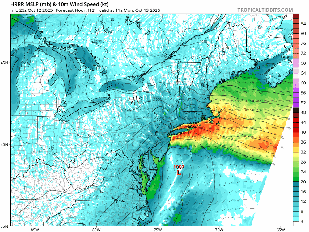
-
Ya, it’s fun I agree. But I wouldn’t read it for a mundane deal like this, but that’s just me. Now if we were on tap for 6-12, or 12-18, with wind…,we’d all be reading, and they, the the NWS, world have the AFD out when it needed to be. Don’t you worry…it’ll be there when it’s something of genuine consequence. But I get the joy of reading it when it’s something siggy.
-
Back in the day AFDs for me were one of the main conduits of learning for me. The Walt Drag AFDs and others really helped my understanding of atmospheric processes. I think times have out changed now and the days of weenie AFDs are virtually gone. Expect maybe for more extreme events.
-
 I finally got to 0.50 inches of rain. I consider that a win. I also got a random 0.08 inches yesterday. I'll add that to my event total when it's all done.
 -
We can agree to disagree. It has less to do with this storm and more to do with receiving a service we used to get regardless of the weather. I enjoy reading the AFD, maybe I’m the only one.
-
Even here at Winni it’s breezy with gusts maybe 25mph or so.
-

Central PA Fall Discussions and Obs
canderson replied to ChescoWx's topic in Upstate New York/Pennsylvania
What a perfect day. Mostly sunny and mid to upper 60s with a 10-15 mph east wind. -
Logan gusting to near 40MPH and steady rains. Could be some high totals in cstl SE MA.
-
But this is why you come here…there are plenty of pros here…and great discussion. If this was mid December onwards, with cold in place…the AFD’s would be out there as you stated. This will not affect any travel on land here in SNE, so that’s why there isn’t a whole lot more on it. It’s not that big of a deal period.
-
 Things picking up here. Heavier winds and heavier rain. About to cross .50”
 -
Rhode Island getting a s*** ton of rain. You can set your clock by it.
-
Yeah I don't think they're gonna let that happen--we're not at the "too late" point. Moving on from Harbaugh this season still leaves some of Lamar's prime left! See it's different this year...and the wheels have legit fallen almost all the way off. Even if Lamar comes back and saves the day again and we somehow back into the playoffs...there's no erasing the stench of what's happened so far. You can cover up a lot when you win the division and make the playoffs...but once crap happens in the regular season too? No kidding it. That's another reason why I think this is gonna be Harbaugh's last season. It is becoming painfully clear that coaching is at the heart of the problem here.
-
Wind starting to pick up a little and it's getting warmer.
-
 Light rain, .30 on day. Winds 10 with maybe gusts in the low 20s at best
 -
.03
-
Evidently going to be a pretty meh storm given the lack of posts in here; .48” so far here in E CT
-

E PA/NJ/DE Autumn 2025 Obs/Discussion
Ralph Wiggum replied to PhiEaglesfan712's topic in Philadelphia Region
Ahhh the Feb 89 debacle. Sophomore in high school. Schools shut down night prior in anticipation. Me and my buddy split a quarter of some good afghani bud. Started walking around the town 8AM. By 11AM we thought maybe we were both just really stoned but there wasnt a snowflake to be had and sun was poking thru. Stopped off for pizza at noon and the workers said we dodged one but the shore was getting hit. Mega pissed. We smoked the rest of our stash and enjoyed our day off, but it was still a huge letdown. - Yesterday
-
1. This won’t come anywhere close to the western basin but it may add some ACE: Tropical Weather Outlook NWS National Hurricane Center Miami FL 800 PM EDT Sun Oct 12 2025 For the North Atlantic...Caribbean Sea and the Gulf of America: Central Tropical Atlantic (AL97): Showers and thunderstorms have increased in association with a small area of low pressure located about 900 miles west-southwest of the Cabo Verde Islands. Environmental conditions are forecast to become more favorable for further development of this system during the next few days, and a tropical depression is likely to form by the middle part of this week while it moves to the west-northwest then northwest at 15 to 20 mph across the central tropical Atlantic. * Formation chance through 48 hours...medium...60 percent. * Formation chance through 7 days...high...70 percent. $$ Forecaster Blake 2. Of more importance landfall potential-wise, a followup AEW has been forecasted by a number of runs and ensemble members to develop close to the Lesser Antilles in ~a week.
-
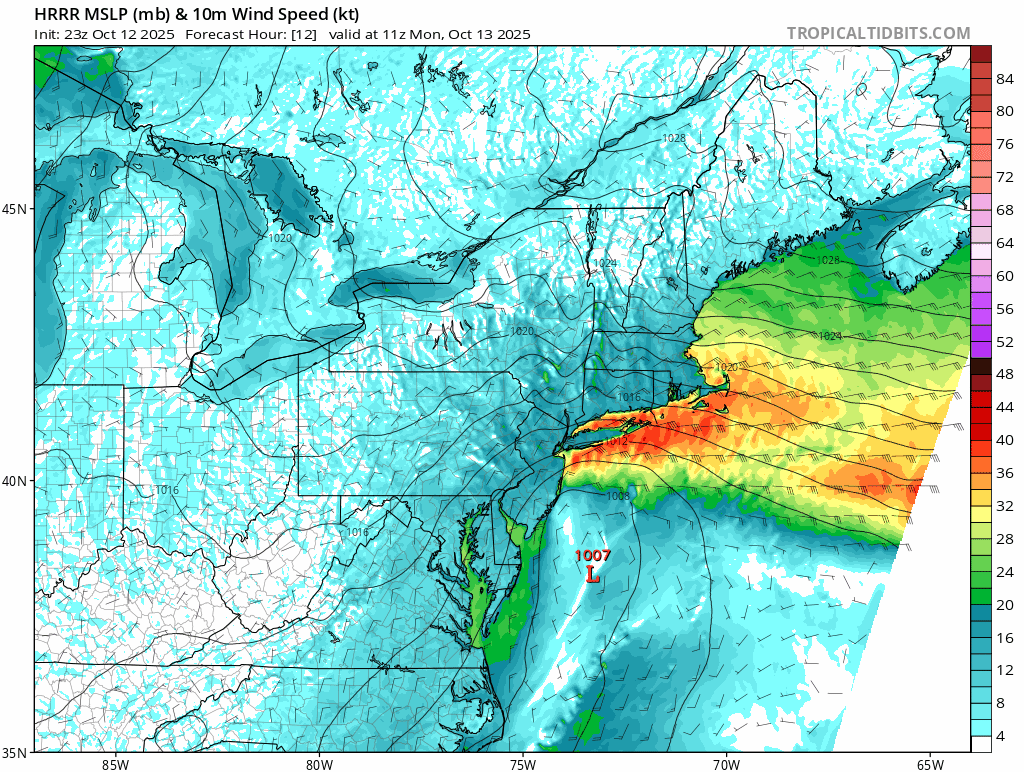
 Now we can begin to see how this might play out as that new low grabs the offshore precip to its north and throws it on shore over NJ and the metro later.................
 -

The return of the elusive Nor'easter. Drought buster or bust?
yoda replied to dailylurker's topic in Mid Atlantic
That's a weird looking radar -

The return of the elusive Nor'easter. Drought buster or bust?
JenkinsJinkies replied to dailylurker's topic in Mid Atlantic

-
Sitting at .02”. Looks like Boston is getting the goods. Oh well.
-
 I will say that there's a low of the Carolinas with new one forming by delimarva