All Activity
- Past hour
-
This means that the NOAA daily PDO is likely back down to the -2.5 to -3 range.
-
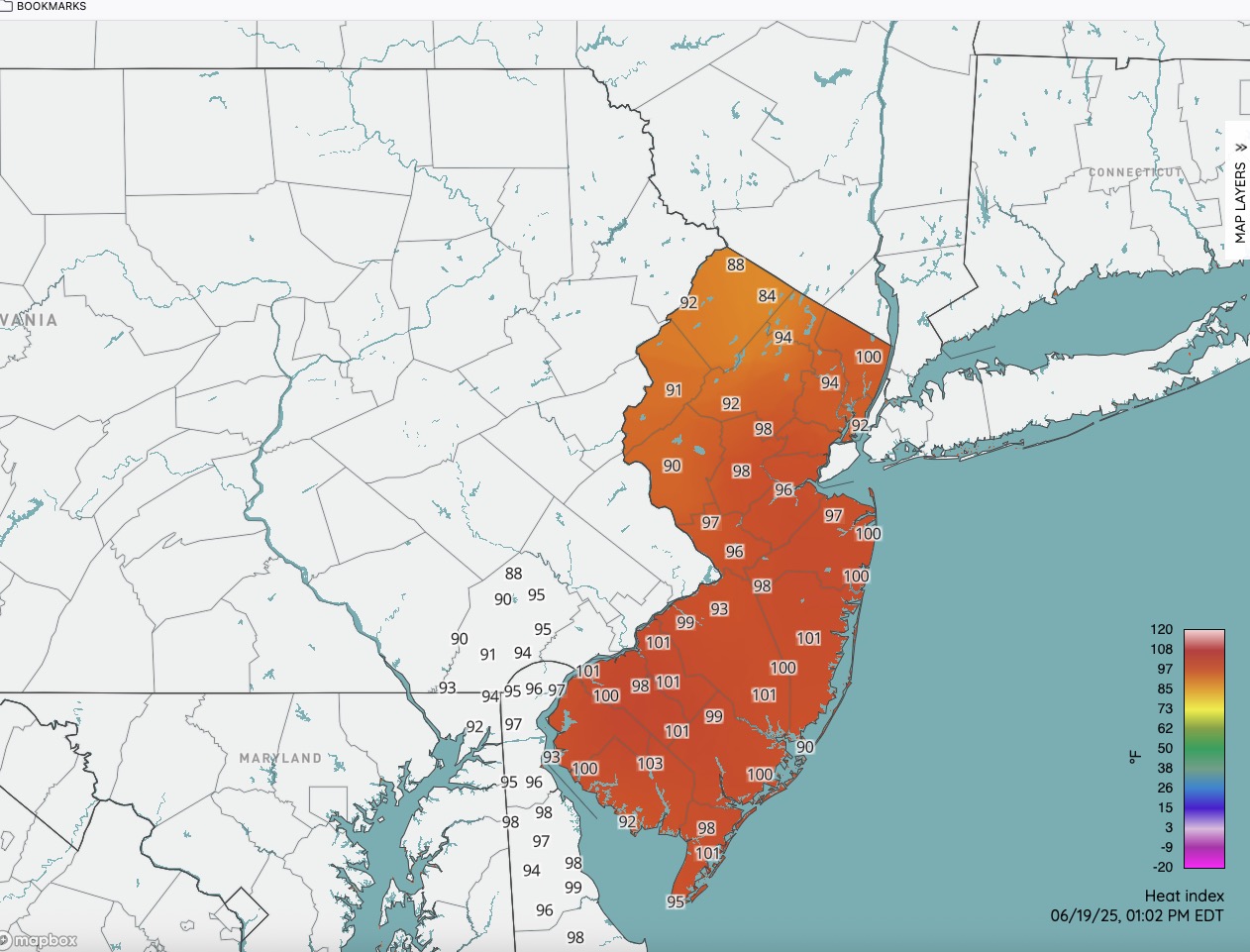
Latest HI numbers. We have cracked 100 in spots.

-
63, cloudy and a NW breeze at 1pm. Hard to believe whats lurking.
-
84/72 Feels great!
-
Nothing close to severe yet
-
"The solar winds, keep comin' in"...
-
Nice storm starting to build over my house. Could feel the cold the breeze from it
-
MU says this is the line to watch: https://weather.cod.edu/satrad/nexrad/?parms=LWX-N0B-1-24-100-usa-rad This will be through here by 4pm. CTP doesn't ramp up precip chances until after 5pm.
-
Air is juicy
-
If you ever get the chance, go to the Bay side of the Cape in August. Especially Brewster to Welfleet. The water is so shallow that when the tide comes back in over those flats...it may as well be FL. It's pretty awesome. First Encounter beach in Eastham is one of my favorites. Nice lazy river there to go floating on as the tide comes in or out.
-
That's awesome! And that's a lot of steps. It really is something how easy it is to put on pounds. Have a safe trip back home.
-
Beaches were full at 10a per my wife. Yikes.
-
86 here, should get at least my 2nd 90 plus day this season over the next few days, maybe today.
-
Head west @weatherwiz Mesoscale Discussion 1363 NWS Storm Prediction Center Norman OK 1144 AM CDT Thu Jun 19 2025 Areas affected...portions of the Northeast Concerning...Severe potential...Watch likely Valid 191644Z - 191815Z Probability of Watch Issuance...80 percent SUMMARY...Scattered strong to severe storms are expected this afternoon with a primary threat of damaging wind gusts. DISCUSSION...Visible satellite imagery shows deepening towering cumulus across central and eastern New York amid moderate instability in an uncapped environment. As storms deepen, some organization/updraft rotation is expected given moderate shear (50 knots at 3km per ENX VWP). Damaging wind gusts and isolated large hail will be the primary threat from this activity. Storm coverage may be somewhat isolated early this afternoon as the upper-level trough and surface front remain across the eastern Great Lakes/southern Ontario. Additional storms may arrive this evening as those features move east, but instability will likely be weaker by this time, and the severe threat remains questionable by later this evening. ..Bentley/Hart.. 06/19/2025 ...Please see www.spc.noaa.gov for graphic product... ATTN...WFO...GYX...BOX...BTV...OKX...ALY...PHI...BGM...BUF... CTP... LAT...LON 41727697 43137600 45007485 45087370 45077361 45037202 44287197 42447221 41197276 40967327 40887370 40797446 40827510 40927587 41117637 41727697 MOST PROBABLE PEAK TORNADO INTENSITY...UP TO 95 MPH MOST PROBABLE PEAK WIND GUST...55-70 MPH MOST PROBABLE PEAK HAIL SIZE...UP TO 1.25 IN
-
wingaersheek Beach up on the N side of Cape Ann, where the Labrador current stuns all else, does that. Coved formation/pools around the beach and very long surf floor - you can walk out a quarter mile a low tide - makes for "fake" warm water there.
-
pop up just southwest of me.
-
yeah I got a random day off, if it were Saturday I'd make a day of it. I was going to Rye, but if there's storms I'd have to backtrack way way west. it's a holiday, but I'd wager traffic will still be gridlock around that time
-
This isn’t the first time. These neutral teases aren’t going to cut it. We need it to break through to sustained +1 at least
-
With a syringe at the corner of her mouth?
-
88/76 real feel 99
-
I love how people complain and whine when it gets hot. This is our climo from now to September it is what it is. Bring the heat!!! Gets some 100’s recorded next week.
-
84 in Methuen
-
I honestly don’t know how my wife and I used to do it with a couple fans all summer. I know it’s getting warmer and more humid, but the climate hasn’t changed that much in 10-15 years. Now with the mini-splits it’s like walking into a freezer when I get home, ha.
-
A light seabreeze would have been nice. The top 4-5' of water can get remarkably comfortable when that happens.
-
Kind of surprised we are almost at 1pm and no MCD. There has been initiation out in WV for a bit