All Activity
- Past hour
-
54 for the low with radiative mid 40s near marydel/woodside sandtown dump area
-
48° here
-
46 this morning.
-
 Where are you? I dropped to 55 degrees in east Queens. Doesn't matter much because temps shot up to the low to mid 70s already, I'm actually surprised it got that warm that quick. Kind of a bummer.
 -

2025-2026 ENSO
TheClimateChanger replied to 40/70 Benchmark's topic in Weather Forecasting and Discussion
On the plus side, it will be the hottest summer on record in the UK. The UK Met Office needs to brace for some unhinged comments from social media users. For some of these guys, 1976 will always be king no matter how hot recent summers are. You can already see some of the trolls from across the pond recycling the same nonsense as the trolls here, about airport tarmacs and jet engine blasts: I suspect the CONUS will slot in around 12th place overall, and warmer than any pre-21st century summers except 1934 & 1936, but I guess that's a big victory for the trolls these days. I've already been called out by the usual suspects for not providing a list of record lows. In reality, I'm just trying to take a break from the trolls! -
You got the stats for before 2000?
-
Looking back at temperatures this month, I think this might be the best August this area has seen in terms of thwarting hot/humid conditions since the summer of 2014. Lows in the area will remain near to below normal for the next 10-14 days leading to some spectacular starts to the days ahead. Will gladly accept after what was a MISERABLE late-June and July.
-
we didn't even try
-
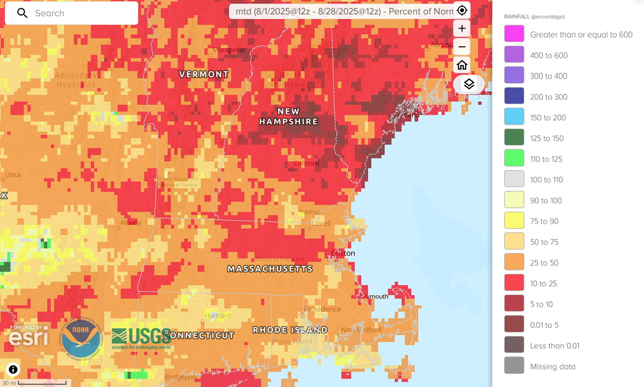
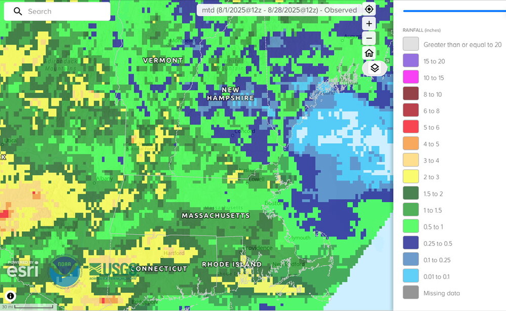
Disaster month north of CON into the Lakes Region % of normal

-
2025-2026 ENSO
TheClimateChanger replied to 40/70 Benchmark's topic in Weather Forecasting and Discussion
This has just been a brutal stretch though. Here is where we were for summer to date through the 15th of the month: And here is where we are now projected to finish: -

Mountain West Discussion
mayjawintastawm replied to mayjawintastawm's topic in Central/Western States
What's interesting the last few days is that despite the seemingly random radar patterns, the distribution of heavy rain seems non-random- the places that get a lot of rain one day tend to get a lot on subsequent days. Would be interesting to see a cumulative map. We got another 0.07" for a total of 0.40" for the 5-day period. -
The Overseas Highway and the Keys is on my bucket list.
-
0.54” here MTD. 0.50” of that was 1 day.
-
48.2 glorious degrees this morning! Was a chilly and delightful walk!
-
Please, please let it be nice when I get home. 2 weeks of ridiculous heat (I mean, I asked for it by choosing to come down here in August) and now I'm ready for a break from this. We've been to the Everglades, Miami and the keys. The Overseas Highway did not disappoint. Quite a contrast from Mammoth Lakes but I've enjoyed them both equally. Heading north tomorrow.
-
 Just move down to the city. I don't know what all the ruckus about cold is about, we didn't drop below 60 here in the city. We probably won't get our first frost until December either lol
 -
UHI keeping me toasty here. Didn't even drop below 60 I think. Fall in the city is always delayed by a solid month due to pesky concrete.
-
Low of 47. Coolest so far this week.
-
I'm split on that. Do we need crazy cold source regions? Probably for sustained retro cold. Doubtful for quick intense shots like we get. Long as the AO flips cold will get delivered somewhere in the mid-latitudes. Other teleconnections help forecast exactly where, but as we've discussed it gets nebulous in the last decade or two. One thing to note is a marine heat wave across much of the northern Pacific Ocean. Parts of the Atlantic are similar. Mercifully it's not all in the Tropical Atlantic. Some hypothesize, and after some success we could say theorize, warmer oceans up north create conditions favorable for blocking. I'm talking general blocking -AO not necessarily cold air destination. So while warm oceans could promote a mild fall, warm SSTs could also set up some winter blocking. Current situation is an example of how it can be warmer than normal in Western Canada, while the Southeast is cool. Well that's an old teleconnection too, but for sustained cold the source does need to reload.
-
I don't think it will be a ratter, but there are some limitations.
-
Hit 43 IMBY. Now if we could only get some decent rain. Got about 12 drops yesterday from some random popcorn cloud.
-

2025-2026 ENSO
40/70 Benchmark replied to 40/70 Benchmark's topic in Weather Forecasting and Discussion
I agree with this...I'm not arguing that there isn't utility in seasonal rankings....however, if you aren't forecasting for a client that requests that and understand the context of currently climo within a warming client than it isn't necessary. I do incorporate use of the 1951-2010 climo period for temps in an effort to "normalize" some of that disparity owed to CC when using analogs...otherwise, most older analogs will appear frigid by today's standards. - Today
-
You could almost sail from Africa to Florida without seeing a single cloud
-
 not super stoked on the temps, i do love me some summer heat. heading out to san diego in a week to grasp my last bit of summer. one good thing, i assume these low temps early in the season will bode well for some vibrant fall colors in a month and a half or so
 -
54 was the low here. Onward nice weather!