All Activity
- Past hour
-
Nice morning, not bad about an hour of total snow. Maybe a quarter inch but the last batch was very festive huge flakes.
-
How many posts of Mjo, JB, and Steve D will it take for you to realize it’s still bare there?
-

2025-2026 ENSO
donsutherland1 replied to 40/70 Benchmark's topic in Weather Forecasting and Discussion
My comment regarding snowfall only goes through December 20th. I think if things grow more favorable for the East Coast, it would be during the December 20-31 period as things stand now. Things can still change beforehand, because teleconnections forecasts lose skill beyond 10-14 days. -

December 2025 regional war/obs/disco thread
WinterWolf replied to Torch Tiger's topic in New England
I’m sick of that thing too…the MJO can go piss off. -
Patience

-
Big storm at the end of this month . Patience is key.

-

Richmond Metro/Hampton Roads Area Discussion
Midlo Snow Maker replied to RIC Airport's topic in Mid Atlantic

-
December 2025 regional war/obs/disco thread
WinterWolf replied to Torch Tiger's topic in New England
Just like everything in meteorology, it seems that there’s always one thing that can trump something else, albeit only in very rare cases, and that seems to be happening with that clipper. I mentioned this a week or two ago, the NAO has not helped us much in the last few years. It either has suppressed systems(yesterdays Virginia snow), and now it’s letting a clipper cut to Ottawa…we can’t seem to win with these NAO blocks. -
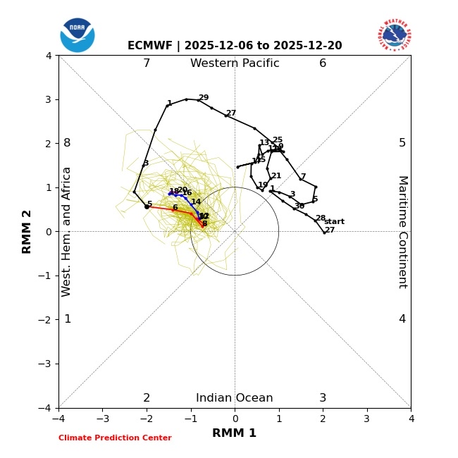
I think the pattern gets better as we head late in December for the east when the MJO gets stronger in phase 8.
-
Glad to see Central and Southern Va get on the board. From Newport News south and east got nothing. But expected. Right along the coast we had no chance. Still early for us given the warmer bays and ocean. Heck I was 44° in the morning when it was snowing at 28° in Yorktown. I can't complain about anything for the next several years given the two big events I had last year. Hopefully December continues to be busy. Congratulations to all...except Hampton Roads.
-
Central CT
-

Central PA Fall Discussions and Obs
Blizzard of 93 replied to ChescoWx's topic in Upstate New York/Pennsylvania
Indeed, now we just need some snow to come along .
-
Beautiful morning. Woke up and saw trees dusted in snow again, was pretty surprised. A solid .2-.3 of new snow.
-
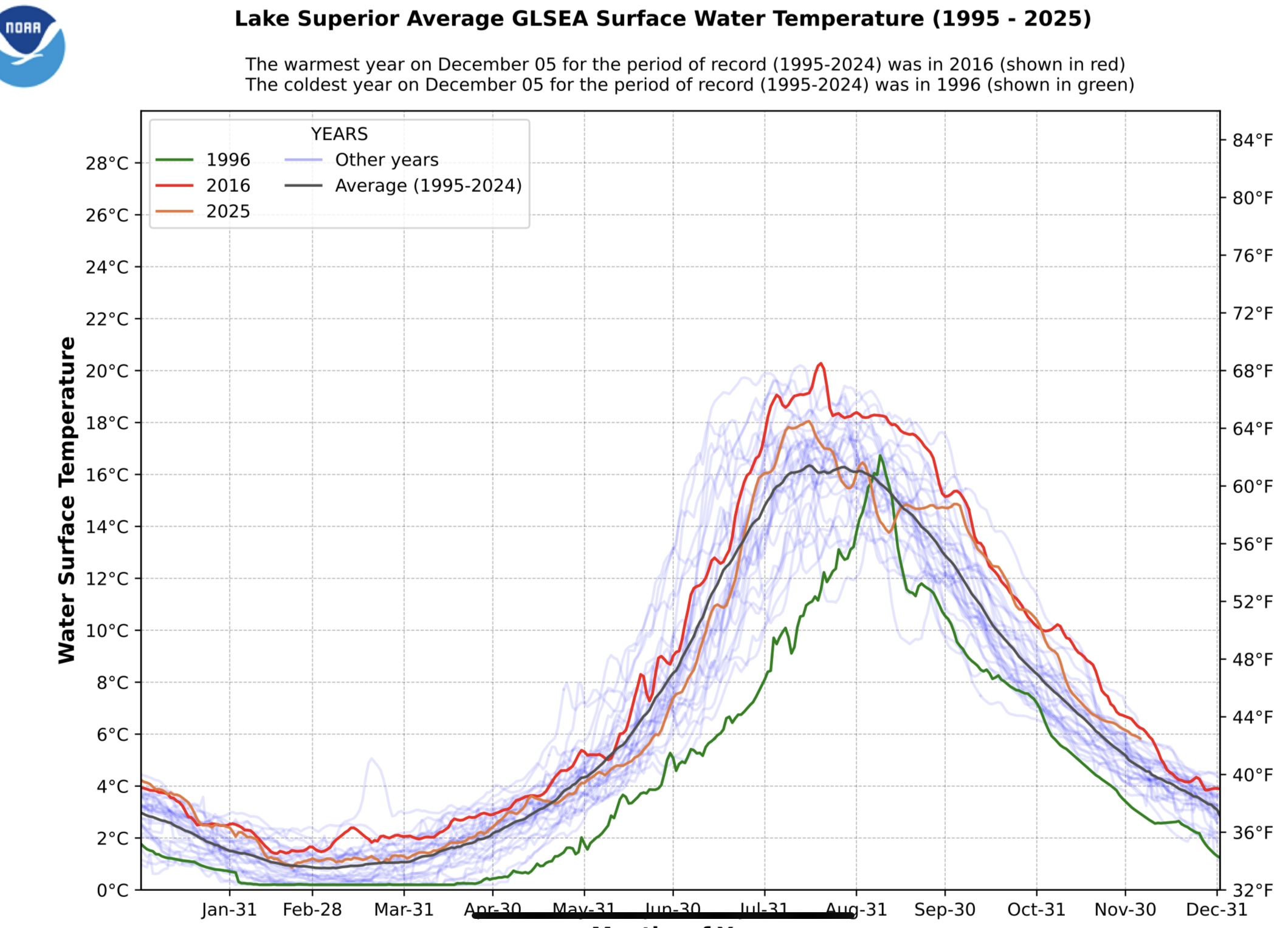
Lake Superior is still the 2nd warmest on record since 1995 for December 5th. https://apps.glerl.noaa.gov/coastwatch/webdata/statistic/pdf/all_year_glsea_avg_s.pdf

-
Wasnt that the dual snow storm/“blizzard” that was very unblizzard like?
-
I meant to ask yesterday, why would it cut so far inland if there is a solid block? I thought a -NAO was supposed to stop these systems from cutting to the lakes.
-
2025-2026 ENSO
donsutherland1 replied to 40/70 Benchmark's topic in Weather Forecasting and Discussion
Today's PNA value was -0.355 with five of the first six days of December seeing negative values. The forecast calls for a continuation of the negative PNA: Nevertheless, the WPO is forecast to dive to below -2.000 on the EPS and to -3.000 or below on the GEFS. As a result, a foundation is being laid for much of eastern North America to wind up colder to perhaps even much colder than normal during the December 11-20 period. This pattern would tend to focus the snows on the Great Lakes region while the East Coast sees lesser snows. PNA- setups typically favor lighter snows on the East Coast. The single exception during December since 1980 was the Boxing Day Blizzard of 2010. Such strongly negative WPO cases also see warmer than normal conditions in the Southwest.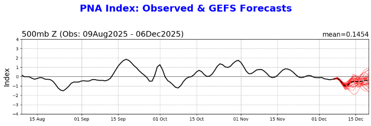
-
Please 13th work out.
-

Central PA Fall Discussions and Obs
Jns2183 replied to ChescoWx's topic in Upstate New York/Pennsylvania
That drought monitor has been a persistent reminder of the unspeakable beast the past 5 years. I long for the era of Lee with its decade straight of above normal preceiptitation Sent from my SM-S731U using Tapatalk -
 Thank you Don. Clarification will eventually be needed.
 -
12/5 3.2 in Forest, VA
-
5 minutes of whacking
-
Steady light snow, but no radar returns
-

December 2025 regional war/obs/disco thread
Go Kart Mozart replied to Torch Tiger's topic in New England
Poundtown down here. 1/4". -

Dec 6-7th (It's not a clipper) Clipper
ChiTownSnow replied to Chicago Storm's topic in Lakes/Ohio Valley
RAP all the way..