All Activity
- Past hour
-
 order synthroid overnight [url=https://levocarepharma.com/#]buy synthroid with fast shipping[/url] buy authentic synthroid tablets
-
the three times I had to go to PHX for work there was some weird weather phenomena...one flash flooding storm, actually made the salt river flow violent for a couple days, a heat wave in July 125+ during the day but the 95+ night wind was worse, and a crazy sand storm I saw coming from south mountain across sky harbor, don't like PHX but Tempe and Mesa were cool. Tempe especially because ASU campus is all around with a plethora of establishments to check out.
-
Heat Island effect - most areas away from the city will experience < 32 well before NYC
-

2026-2027 Record-breaking El Nino
MJO812 replied to Stormchaserchuck1's topic in Weather Forecasting and Discussion
Stop trolling Its annoying -
Torch !
-
The latest first freeze for LGA which is the UHI capital was 1-4-16. NYC snuck one in on 11-24-15. The average first freeze for LGA since then has been 11-30 and NYC 11-20. Frost/Freeze Summary for LAGUARDIA AIRPORT, NY Each section contains date and year of occurrence, value on that date. Click column heading to sort ascending, click again to sort descending. 2015 03-29 (2015) 27 01-04 (2016) 15 280 2001 03-28 (2001) 31 12-23 (2001) 32 269 1998 03-22 (1998) 31 12-22 (1998) 24 274 2021 04-02 (2021) 29 12-19 (2021) 31 260 Data for November 24, 2015 through November 24, 2015 Click column heading to sort ascending, click again to sort descending. NY MONTAUK AIRPORT WBAN 37 NY SETAUKET STRONG COOP 35 NY LAGUARDIA AIRPORT WBAN 33 NY NY CITY CENTRAL PARK WBAN 32 NY JFK INTERNATIONAL AIRPORT WBAN 31 Frost/Freeze Summary for LAGUARDIA AIRPORT, NY Each section contains date and year of occurrence, value on that date. Click column heading to sort ascending, click again to sort descending. Minimum 03-01 (2020) 11-08 (2019) 226 Mean 03-25 11-30 249 Maximum 04-06 (2016) 01-04 (2016) 281 2025 03-23 (2025) 32 12-04 (2025) 25 255 2024 03-24 (2024) 32 11-30 (2024) 32 250 2023 03-30 (2023) 32 11-25 (2023) 32 239 2022 03-30 (2022) 30 11-19 (2022) 32 233 2021 04-02 (2021) 29 12-19 (2021) 31 260 2020 03-01 (2020) 26 12-08 (2020) 32 281 2019 03-13 (2019) 32 11-08 (2019) 31 239 2018 04-02 (2018) 32 11-15 (2018) 30 226 2017 03-23 (2017) 26 11-10 (2017) 27 231 2016 04-06 (2016) 32 12-09 (2016) 32 246 2015 03-29 (2015) 27 01-04 (2016) 15 280 Frost/Freeze Summary for NY CITY CENTRAL PARK, NY Each section contains date and year of occurrence, value on that date. Click column heading to sort ascending, click again to sort descending. Minimum 03-01 (2020) 10-31 (2020) 218 Mean 03-28 11-20 236 Maximum 04-10 (2016) 12-09 (2016) 250 2025 04-09 (2025) 31 11-29 (2025) 32 233 2024 03-24 (2024) 31 11-30 (2024) 30 250 2023 03-30 (2023) 31 11-25 (2023) 30 239 2022 03-30 (2022) 29 11-19 (2022) 31 233 2021 04-03 (2021) 32 11-23 (2021) 32 233 2020 03-01 (2020) 25 10-31 (2020) 32 243 2019 03-18 (2019) 32 11-08 (2019) 29 234 2018 04-09 (2018) 32 11-14 (2018) 32 218 2017 03-23 (2017) 23 11-10 (2017) 25 231 2016 04-10 (2016) 31 12-09 (2016) 29 242 2015 04-01 (2015) 32 11-24 (2015) 32 236
-
If I’m remembering correctly, we had a super El Niño during the winter of 2015–2016. That November brought an unusually cold outbreak, with highs in the teens around midmonth, before a more typical El Niño pattern took hold for the rest of winter. With a recurving typhoon, Ural blocking, a weakening polar vortex, and other factors potentially lining up, I’m wondering whether we could see a similar November this year. Thoughts or rebuttals?
-
Max 64.1° What a beaut. Hopefully a few days like this every month until spring.
-
12z Euro looks great through early Novie
-
google it - its not made up AI Overview A polar vortex stretching event occurs when the large, circular ring of freezing stratospheric air above the North Pole loses its tight shape, elongating or warping into an oval or multi-lobed form. [1, 2]
-
Hopefully we get a nice late Fall threat, otherwise May isn't too terribly far off
- Today
-
Not to be weird but I wish you could enjoy it too!
-
I think it’s Indirectly a fallout from all the tropical systems off the Mexico coast this year. All that moisture swarming north. But I’ll take it!
-
Enhanced risk added with the D2 this afternoon for hail
-
toprol xl rxlist: Pulse Guard Direct - metoprolol side effects first week
-
I've never heard of Polar Vortex stretching before. This is a made up term!
-
Same up here and most of Maine where I've been this past week.
-
I think it’s a rare severe threat out there too.
-
Yeah the water restrictions will likely come back.
-
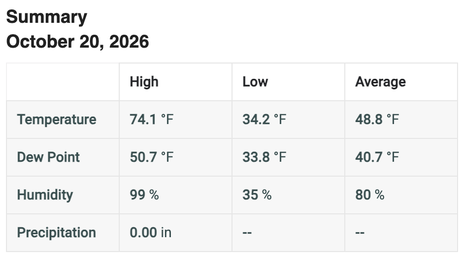
Beauty of a day here. Wife and I got almost the whole woodpile stacked but it got warm out there. No complaints!
-
 Based on old recon finding lots of sub 900 storms in that basin and this having that very high end look it likely was below 890. .
-
 Pressure data from a buoy on the edge of the eye sugguests sub-900mb pressure
-
The red oak sapling outside the window has a nice but not vibrant burgundy color but the 24"/90ft red oak 50 yards away is going toward brown. The only bright red oaks I see in this area are the pin oak street trees in Farmington - moderately common in the mid-Atlantic but not native to Maine. Jeff has a couple of them in his yard; haven't heard how they've colored this fall. Other than the oaks and some dark yellow understory beech, we're in stick season. Many of those beech leaves will turn tan and hang on until bud break in May. 22/25/27 lows the most recent 3 mornings.
-
 JTWC had this at 155kt this morning, and so that's an incredible situtation, it's much above the 137kt cutoff for Category 5.
-

2026-2027 Record-breaking El Nino
forkyfork replied to Stormchaserchuck1's topic in Weather Forecasting and Discussion
the center of the pac warm pool is east of the dateline!!! you would need this event to collapse to have any chance