All Activity
- Past hour
-
(002).thumb.png.6e3d9d46bca5fe41aab7a74871dd8af8.png)
Boxing Night Snow/Sleet/Ice Dec 26-27 Storm Thread/Obs.
ChescoWx replied to Mikeymac5306's topic in Philadelphia Region
That said many of us are more than 150% of normal snowfall and having a well below normal temperature December. We are about to see our 6th winter event of this young winter season. Snow begets snow and I very much suspect we have many more winter weather events in our future. Keep the faith those of you on Team Snow! -
these north trends can sometimes continue right up until go time
-
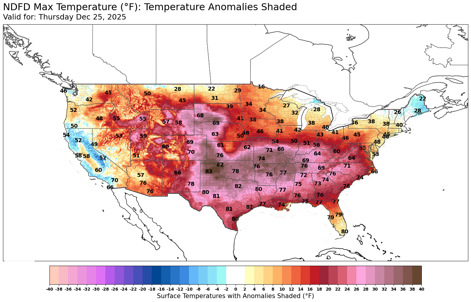
Christmas Day…sunny, 50F. So predictable.
-

26th-27th event, coming at us like a wounded duck.
SouthCoastMA replied to Go Kart Mozart's topic in New England
Weren't the SREFs already bad, then had a huge upgrade a few years ago that made them
-
same spot here....hard to know which forecast to go with, mt holly or upton....i can literally walk to union co.
-
I don't see a big NE shift. Maybe 25 miles or so. And maybe came down a little on QPF.
-
Wow big range
-
Hrrr swings more than swingers themselves.
-
In the end, the torch was not denied.
-
this is obviously not as extreme - but I still consider myself here in extreme northern Middlesex County under a Winter Storm Warning because Upton still has Union County under one .........
-
but the icon kuchera map showed nyc getting 6"
-

December 2025 Short/Medium Range Forecast Thread
Carvers Gap replied to John1122's topic in Tennessee Valley
For really the first time in a few weeks, ensembles are pretty bullish with the exception of the GFS/GEFS which are just worlds apart from any other model - even its own AI model. They are outliers. In my book, though, the deterministic models have led the way. Something is not right w/ wx modeling right now. I maybe can remember one winter where modeling was completely blind to cold fronts. The GEM, with its cold bias, is useful right now, because it exaggerates the pattern enough to find them. Sometimes when graphics are exaggerated (like increasing exposure on a camera), one can spot details which can't be spotted otherwise. In this case, the GEM is spotting cold fronts in a similar manner. Just subtract the cold bias. My guess is the mistakes are occurring with the MJO region which has no real clear signal, the extreme cold in Canada, the NAO stepping onto the scene, and was the Aleutian high over estimated in terms of staying power? Throw in some atmospheric river stuff...and it is understandable that struggles are occurring. But this deal where the GFS can't even see a cold front past d7 is really weird - something has been tweaked in the model IMHO. It is just missing wildly right now...unless the pattern is warm. -
12Z for reference
.thumb.png.e7224b5271850ac3399ce79fb537cbba.png)
.thumb.png.a71c8c05116f22a8b6bb64a42d6668a3.png)
-

Central PA Winter 25/26 Discussion and Obs
Jns2183 replied to MAG5035's topic in Upstate New York/Pennsylvania
Advisory up forum wide URGENT - WINTER WEATHER MESSAGENational Weather Service State College PA215 PM EST Thu Dec 25 2025PAZ006-011-012-018-019-025>028-034>037-041-042-045-046-049>053-056>059-063>066-261700-/O.UPG.KCTP.WS.A.0012.251226T1200Z-251227T1200Z//O.NEW.KCTP.WW.Y.0027.251226T1700Z-251227T1200Z/Potter-Cameron-Northern Clinton-Northern Centre-Southern Centre-Blair-Huntingdon-Mifflin-Juniata-Bedford-Fulton-Franklin-Tioga-Northern Lycoming-Sullivan-Southern Clinton-Southern Lycoming-Union-Snyder-Montour-Northumberland-Columbia-Perry-Dauphin-Schuylkill-Lebanon-Cumberland-Adams-York-Lancaster-Including the cities of Lebanon, Coudersport, Danville, Berwick,Williamsport, Lewistown, Sunbury, Chambersburg, Huntingdon,Altoona, Renovo, State College, Lewisburg, Newport, Mifflintown,Lock Haven, Mount Union, Mansfield, Pottsville, Selinsgrove,Gettysburg, Shamokin, Wellsboro, Laporte, Carlisle, Lancaster,York, Philipsburg, Hershey, Bloomsburg, Bedford, Harrisburg,Emporium, McConnellsburg, and Trout Run215 PM EST Thu Dec 25 2025...WINTER WEATHER ADVISORY IN EFFECT FROM NOON FRIDAY TO 7 AM ESTSATURDAY...* WHAT...Mixed precipitation expected. Total snow and sleet accumulations up to two inches and ice accumulations up to two tenths of an inch.* WHERE...A portion of central Pennsylvania.* WHEN...From noon Friday to 7 AM EST Saturday.* IMPACTS...Plan on slippery road conditions. The hazardous conditions could impact the Friday morning and evening commutes.PRECAUTIONARY/PREPAREDNESS ACTIONS...Slow down and use caution while traveling. The latest roadconditions for the state you are calling from can be obtained bycalling 5 1 1.&&$$For more information from the National Weather Service visitweather.gov/StateCollegeMartin/Lambert/Tyburski Sent from my SM-S731U using Tapatalk -
as i noted, in march 2017 i watched a 2 foot blizzard devolve into several inches of sleet; the sleet reached far and wide and no one, even where it snowed, got the 2 feet...but that was in march.
-
Very impressive gradient in the Dakotas.
-
HRRR with a significant NE shift unfortunately. Still very good for our area though, the main band just shift north from 12Z (still snowing here)
-

26th-27th event, coming at us like a wounded duck.
SJonesWX replied to Go Kart Mozart's topic in New England
I’m mostly watching this from the sidelines, but it would be a pleasant surprise if we managed to squeeze out an inch. Zero confidence on anything measurable here -
my experience is that if it gets to trenton, it's going further and will make it all the way to staten island and the city; they are not that far apart really.
-

December 2025 Short/Medium Range Forecast Thread
jaxjagman replied to John1122's topic in Tennessee Valley
Merry Christmas to all by the way!! I left one out the more important one,while yes it's a -NAO,its still a more based -ENAO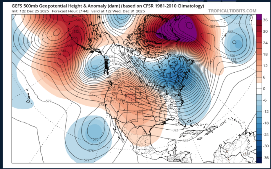
-
The bust potential is above average with this storm - because forecasters are playing the snow vs. mix game especially around central NJ
-

E PA/NJ/DE Winter 2025-26 Obs/Discussion
RedSky replied to LVblizzard's topic in Philadelphia Region
49F -

26th-27th event, coming at us like a wounded duck.
Sey-Mour Snow replied to Go Kart Mozart's topic in New England
HRRR about to bang this run / NE Trend continues this one will jack my Binghamton to BDR zone -
Happy torchmas
-
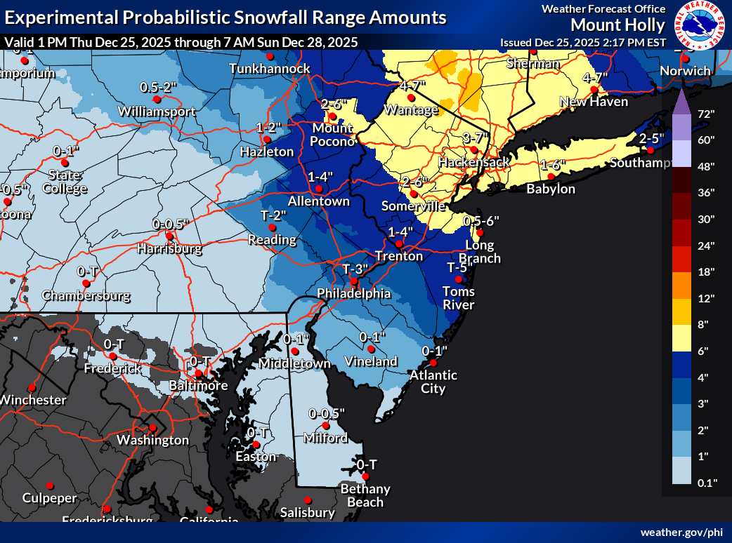
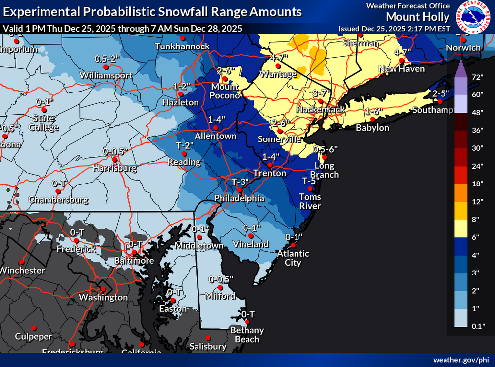
This is updated snow amounts from mount Holly. They haven't updated they're warning details yet.


.png.a085d1fd7cb3f36b7a6f757ebef54180.png)
.png.a44e9303382c39b805bd3cf20718aa80.png)