All Activity
- Past hour
-

NEW DISTURBANCE: Central Tropical Atlantic (0/20)
BarryStantonGBP replied to BarryStantonGBP's topic in Tropical Headquarters
DO YOU HEAR THE PEOPLE SING SINGING A SONG OF ANGRY MEN IT IS THE MUSIC OF A PEOPLE WHO WILL NOT BE SLAVES AGAIN OUI OUI BAGUETTE EIFFEL TOWER -
Today is the final post 8 pm sunset for MDT until next year. Hallelujah.
-
I don't grow crops. Grass mostly gone. Sunflowers dried up. Most of the plants are still ok but I need to start watering more regularly if it doesn't rain soon.
-
So... your corn field is too dry lol. Mine is still too wet!
-
A few here have already called for the coldest winter in 50 years
-
No rain here in over two weeks. Everything's dried up/dead, except weeds. IDGAF.
-
you edited the post. Nm ok
-
Picked up 0.00" of rain here. 1.04" for the month. One last crack at it tomorrow night, and then it looks pretty dry until the end of the month.
-

Hurricane Erin: 125 MPH - 940mb - WNW @ 14
BarryStantonGBP replied to BarryStantonGBP's topic in Tropical Headquarters
OI RECKON EKIN WILL SCORE ANOTHER CAT 5 GOAL? got a mate watching her live in the love island villa he crashed while I’m pissed from last night in Pacha Disappointed she’s a category 3 but oh well steaming hot water ahead and low shear now that she’s fixing her eyewall after a trip to specsavers -
Awesome, enjoy six months of November before Wiz starts his countdown to May 1 disappointment thread again.
-
NYC was also very low with snow in 1950-1. Regardless, one season, alone, doesn’t destroy the theory because these correlations are not only not even close to 100%, they’re weak. If I instead had claimed it was a 100% perfect correlation, then that idea could be destroyed by just one season.
-

Hurricane Erin: 125 MPH - 940mb - WNW @ 14
nvck replied to BarryStantonGBP's topic in Tropical Headquarters
This is the OP from twitter, not sure how he made it. https://x.com/NickKrasz_Wx/status/1956730795533480017?t=KwNUUdLNnK9aEhPWPNV-7A&s=19 -
And like any relationship, it can always be overwhelmed by other factors working against it. I think @bluewave may have had the right idea that as teleconnections change with cc, potential connections like this become less reliable.
-
-

Hurricane Erin: 125 MPH - 940mb - WNW @ 14
jconsor replied to BarryStantonGBP's topic in Tropical Headquarters
@bugalou These graphics of NHC cone/track overlaid with Erin satellite loop are very helpful. Did you create this via an app or website? I am familiar with WeatherNerds satellite loops that allow overlay of EPS/GEFS members. The CIMSS storm-specific page allows overlay of the *current* NHC track, but doesn't dynamically update it every 6 hours as your loop did: https://tropic.ssec.wisc.edu/real-time/storm.php?&basin=atlantic&sname=05L&invest=NO&zoom=4&img=1&vars=111110000000000000000000&loop=0&llval=OFF - Today
-
Worst climo trend continues. Man f*** West Michigan.
-
A much needed quality soak this morning, much of Champaign was 7” below normal rainfall for the summer.
-
ORH is SNE. Chestnut tree fall on head?
-
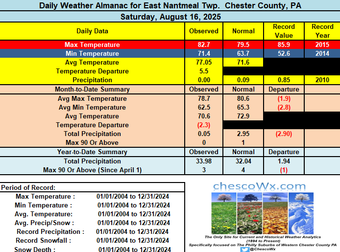
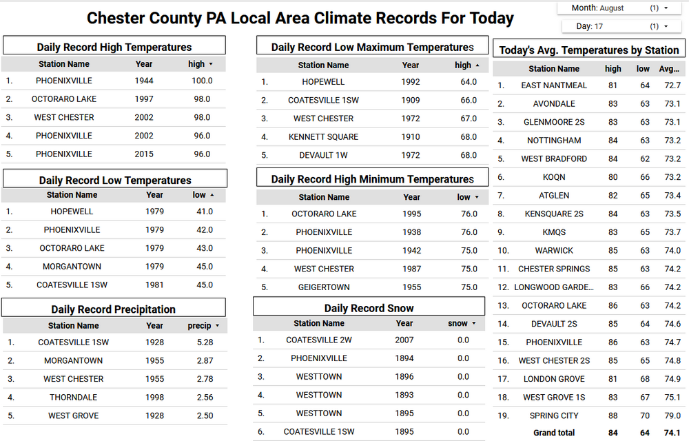
Today will be our 6th straight above normal temperature day. It will also be our last such day for at least the next week as we should see temperatures at or below normal levels much of the time. It looks like we have a good chance at finishing August with below normal temperatures. If so this would be the 4th below normal month over the first 8 months of the year. We could see some rain and thunderstorms especially this evening with the cold frontal passage. The line should move west to east across the area between 6pm and 8pm. Any storms could produce a 1/4" to 1/2" of much needed rain as we have had very little rain across the northern parts of Chester and SE Berks counties so far here in August.
-

E PA/NJ/DE Summer 2025 Obs/Discussion
ChescoWx replied to Hurricane Agnes's topic in Philadelphia Region
Today will be our 6th straight above normal temperature day. It will also be our last such day for at least the next week as we should see temperatures at or below normal levels much of the time. It looks like we have a good chance at finishing August with below normal temperatures. If so this would be the 4th below normal month over the first 8 months of the year. We could see some rain and thunderstorms especially this evening with the cold frontal passage. The line should move west to east across the area between 6pm and 8pm. Any storms could produce a 1/4" to 1/2" of much needed rain as we have had very little rain across the northern parts of Chester and SE Berks counties so far here in August. -
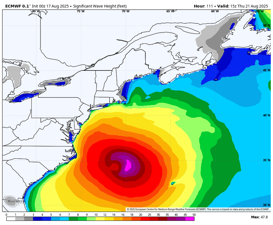
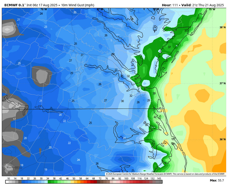
Let's see... The last several Advisories. Not made up and documented. Adjusted forecast track "nudged" to the W. A WNW movement to continue with an "expected" turn to the N. ERIN was NEVER forecasted in the earlier advisories to be located at the present position. Just something to watch, BE AWARE, going forth. HFSA 2am. Thursday 72.3W 33.85N (closest approach) Only then a fish let off the hook.
-
My farm field needs less water. You- My corn field needs more water. Me- My corn filed needs more sunny mornings. Some other dude- My corn field needs cooler weather. Grumpy ass farmers are never satisfied.
-
it's been hot in Indiana too. What does that have to do with SNE?





.thumb.png.4150b06c63a21f61052e47a612bf1818.png)


